
SPH Engineering's controlled tests point to that order. Different sensors flown at the same low height produced similar detection counts, while the same sensor flown lower found far more targets. The larger gaps between systems came from mounting and flight conditions: sensor sway, heading error, payload margin and RTK quality.
How this comparison was made
SPH Engineering manufactures MagNIMBUS and integrates and supports the SENSYS MagDrone range and the Geometrics MagArrow II. The GEM Systems DRONEmag GSMP-35U is included as an external benchmark; SPH does not sell it.
The evidence comes from separate tests, not one standardized shootout. Targets, flight heights, speeds and mounting differed between tests, so results should be compared within a test, not across tests.
- Three Baloži comparisons (UXO, buried utilities, high altitude), September 2023. The UXO test ran on 21 September 2023 at SPH's UAV test site in Baloži, Latvia, and all four magnetometers were mounted on a DJI Matrice 300 RTK with RTK positioning.
- The Oklahoma State University seeded field. On 9 May 2024, at OSU's CENFEX range in Pawnee County, 131 ferrous and non-ferrous items were buried up to 20 cm deep or placed on the surface across 280 m².
- A ground versus drone comparison. It ran on 18 September 2024 at the Baloži range, comparing a ground-based GEM Systems GSM-19W with MagNIMBUS and the MagDrone R1.
- One independent peer-reviewed study by Italy's National Research Council (CNR IREA).
Specifications come from manufacturer datasheets where available, and the table notes where SPH's figures differ. The raw datasets from SPH's tests are published, so any result below can be reprocessed independently.
Which architecture fits which survey?
Match the system architecture to the survey goal first, then pick the product. This matrix is a shortlisting tool for this article, and is not to be treated as an industry standard. The sections below give the evidence behind each row.
Why sensor-to-target distance decides detection
Detection depends first on the distance between sensor and target. At survey distances, a compact ferrous object behaves approximately as a magnetic dipole, and the field amplitude it produces falls roughly with the cube of that distance. Assuming a 10 nT noise floor, a 40 mm shell detectable at 54 cm would likely be missed if the sensor flew just 15 cm higher (Billings et al. 2006). SPH's estimates of UXO detection distances apply the same models to common ordnance types.
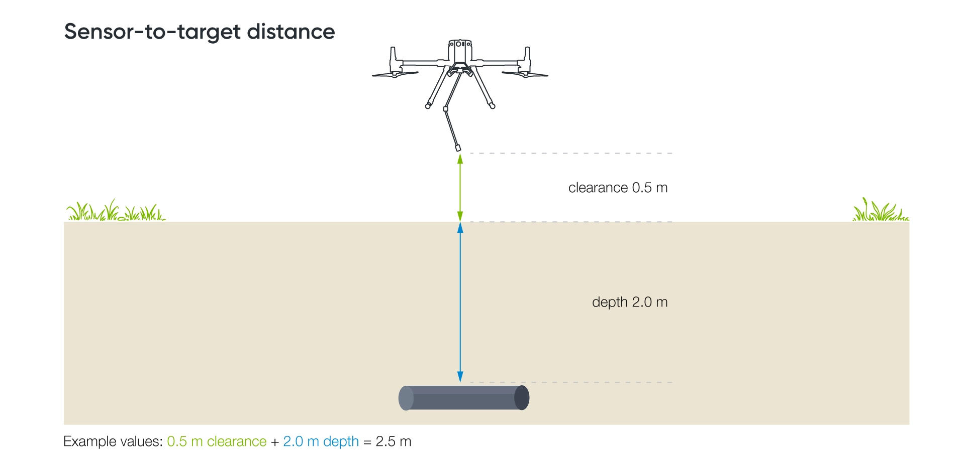
That distance is sensor clearance plus burial depth, and the Baloži UXO test used this geometry. Its flight heights stood in for sensor-to-target distance, so a 2.5 m pass gives a first-order reference for a sensor 0.5 m above ground and a target buried 2.0 m deep. Target orientation, size and magnetization still change the real result. SPH's own detection-distance estimates assume the orientation that produces the strongest signal.
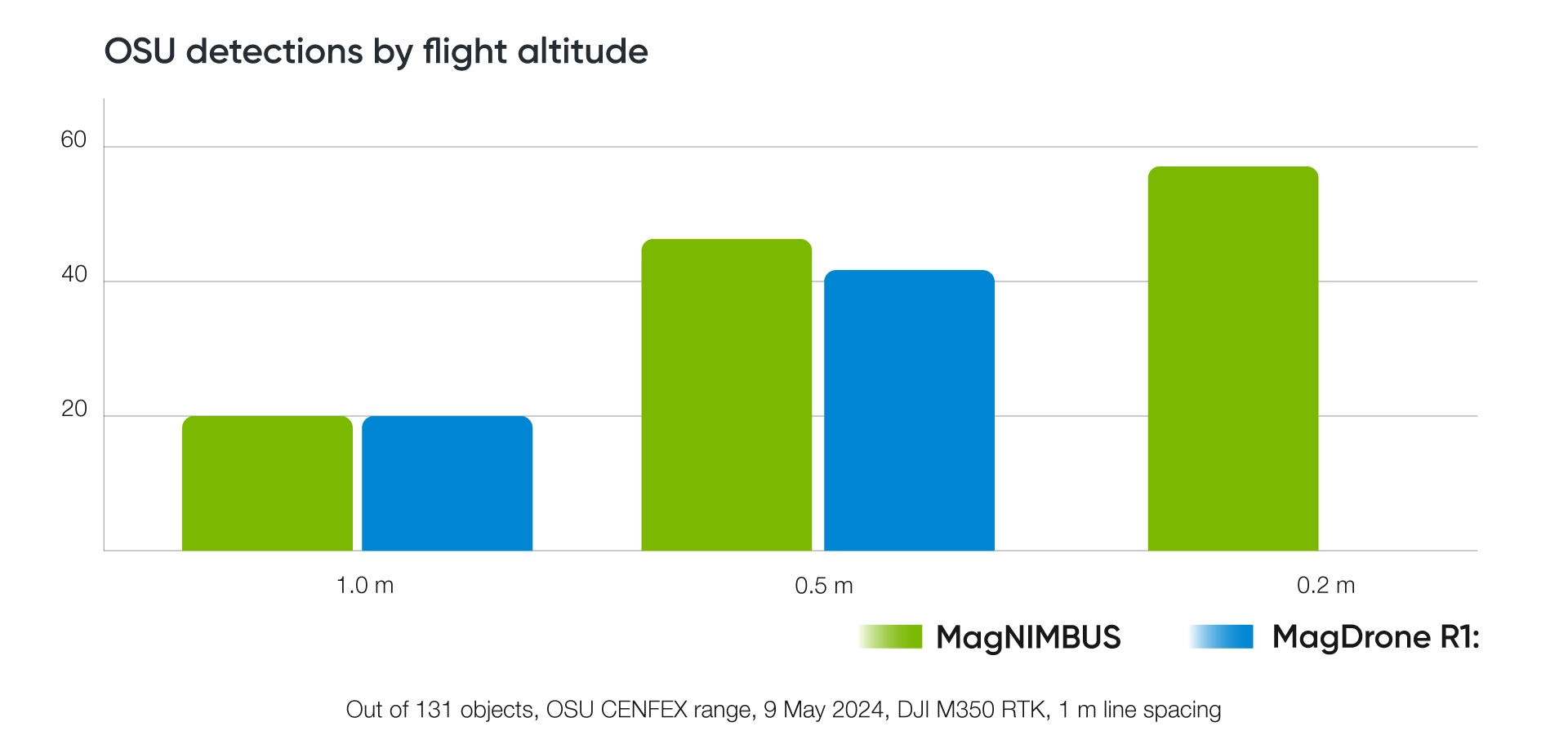
The OSU seeded field shows the effect at survey scale. At 1.0 m sensor altitude, MagNIMBUS and the MagDrone R1 each identified 20 targets. At 0.5 m, 43 objects were detected with MagNIMBUS and 41 with the MagDrone R1. The authors attribute the remaining differences mainly to slightly different flight paths, since a sensor passing closer records a stronger signal, and not necessarily to the sensors.
At 0.2 m, only MagNIMBUS data exist. Technical issues affected the R1 data at that height, and MagNIMBUS identified 57 objects. The 57 figure therefore compares altitudes for one system; it says nothing about MagNIMBUS versus the R1. Lower flights also carry a planning cost. Detecting smaller targets from lower altitude requires flight lines to be spaced more tightly to keep coverage.
A sensor's datasheet noise figure is only one input into field performance. QuSpin, which makes the sensor inside MagNIMBUS, says as much: intrinsic sensitivity is only one factor, because drone measurements also pick up environmental noise, platform-generated fields, motion effects, heading error and positioning uncertainty. The chain that decides a result runs from target size and burial depth through clearance, mounting, motion and heading error, then positioning, line spacing and processing.
Is a fixed mount or a suspended sensor better?
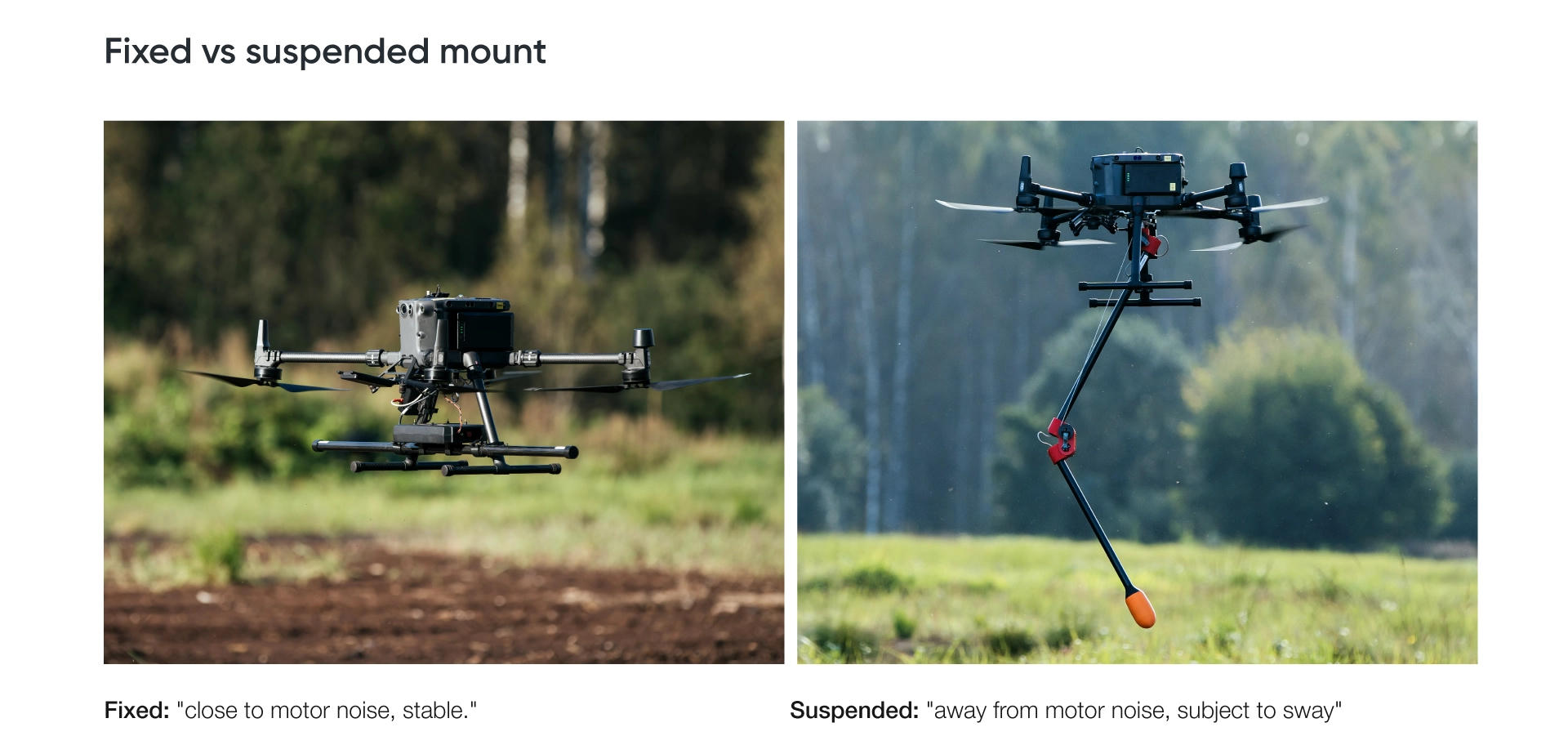
At low altitude, fixed mounts matched or beat suspended ones in the Baloži tests. At higher altitude, where the target signal nears the noise floor, the suspended systems kept indications furthest, although suspension was not the only variable that changed.
In the September 2023 UXO test, the suspended MagArrow II and GSMP-35U showed no benefit over the fixed MagNIMBUS and R3 under those survey conditions, because motor noise caused fewer problems than the swaying of the suspended setups and the heading error that swaying produces.
The utilities test pointed the same way. The MagArrow II resolved target anomalies arguably better fixed to the drone legs than suspended, though both setups gave very good results. The GSMP-35U returned the noisiest data, which the authors traced to the weight of the setup overloading the drone in windy conditions.
Altitude reverses the pattern. Over two parked vehicles, all sensors detected both signals up to 25 m above ground, and the suspended GSMP-35U still showed a notable signal at 34 m.
The CNR IREA study over buried pipelines in southern Italy reported broadly consistent trade-offs (Sensors, 2025). The rigid MagNIMBUS gradiometer configuration was more stable and operationally efficient, while the suspended MagArrow had lower UAV-interference noise but was more affected by oscillation-related instability; its separately derived vertical-gradient result was less stable than the simultaneous MagNIMBUS gradiometer result. Neither architecture came out ahead on every measure. The vertical-gradient difference comes from acquisition geometry: MagNIMBUS records both sensor levels simultaneously, while a MagArrow-derived gradient requires separate flights and is therefore more sensitive to flight-to-flight variability. SPH's summary of the CNR IREA pipeline comparison covers the field setup in more detail.
Suspension also affects drone choice. SPH recommends larger drones for the MagArrow because it hangs on four 3 m suspension cords that need at least 1 m between attachment points; it can fly on a DJI M350 RTK, but its stability degrades. Suspended setups should also fly a heading calibration flight.
Should you choose a fluxgate or an atomic total-field magnetometer?
Both sensor types detected discrete metal objects equally well at low altitude in SPH's tests. At OSU, the atomic MagNIMBUS and the fluxgate MagDrone R1 produced near-identical counts at 1.0 m and 0.5 m. In the ground versus drone comparison, the MagDrone R1 performed as well as MagNIMBUS.
At higher altitude the evidence is harder to read, because sensor type was never the only variable. Over two parked vehicles, MagNIMBUS and the MagDrone R3 both resolved separate signals up to about 28 m. Above that the R3 showed no clear signal, which the authors attribute to a higher noise floor from sensors mounted near the drone motors. The suspended MagArrow II kept faint indications at 31 m and, less clearly, 34 m. The suspended GSMP-35U gave a clear signal at 34 m. Sensor technology, distance from the airframe, suspension and wind all changed together. The test shows how complete systems behave near the noise floor, and it cannot rank sensor types on its own.
The SENSYS MagDrone fluxgates systems measure the magnetic field along three axes. The SENSYS MagDrone range uses FGM3D/75 sensors with a ±75,000 nT measurement range. SENSYS states that 200 Hz sampling lets the MagDrone series filter out noise from mains frequencies, infrastructure and drone motors, which is why the units can mount directly on the landing gear. Their compact size is what allows two or five sensors on one boom.
Atomic total-field sensors measure magnetic-field magnitude and can provide very low noise floors. QuSpin reports a floor of roughly 3 pT/√Hz per sensor for the QTFM Gen-2, the rubidium sensor in MagNIMBUS. Geometrics specifies the cesium MagArrow II at 0.005 nT/√Hz typical noise, with no dead zone. The MagArrow's two sensors sit in different orientations so they never hit a dead zone at the same time, and they produce a single reading, not two survey channels.
Export requirements depend on the product and the destination. SPH lists no export restriction for MagNIMBUS beyond an end-use certificate, and none for the MagDrone systems. Geometrics classifies its standard cesium magnetometers, including the MagArrow, under US export category ECCN 6A006. Most destinations may need a US export license, and the process can take anywhere from 6 weeks to 6 months. Geometrics also offers a global version classified ECCN 6A996 that needs no license for most countries, but it has a higher noise floor. Confirm its performance before it replaces the standard unit in a survey plan.
Weight bases differ between manufacturers. Confirm the ready-to-fly payload, including mounts and cables, with SPH before choosing a drone.
Product notes
MagNIMBUS for the lowest clearance and a one-pass gradient
MagNIMBUS can fly with the sensor a few dozen centimeters above the surface, and contact with the ground or vegetation does not bring the drone down. The gradiometer configuration improves quality for specific tasks. For vertical-gradient processing, the two sensors' simultaneous measurements cancel time-varying changes in the Earth's field, which usually removes the need for a separate base station. Requirements may differ if corrected total-field data are also a deliverable. SPH also lists the gradiometer for surveys near power lines; how much it helps depends on the interference frequency and the site. The single-sensor configuration detects the same targets but needs more experienced processing and sometimes a base station.
In the September 2023 Baloži utilities test, MagNIMBUS returned arguably the best results, with low noise and well-defined target signals.
SENSYS MagDrone R1: a single fluxgate on the same folding design
The MagDrone R1 shares MagNIMBUS's mechanical design, allowing very low sensor clearance, and it requires SkyHub because it has no internal recorder. It matched MagNIMBUS at OSU at 1.0 m and 0.5 m, and again in the September 2024 ground versus drone test.
SENSYS MagDrone R3 doubles the survey traces on a compact 1 m bar
The MagDrone R3’s two sensors record two traces per pass, cutting flight time by at least half compared with single-sensor setups. In the Baloži UXO test, the R3 finished each altitude pass in 1.5 minutes, the MagArrow II in 3 minutes, and MagNIMBUS and the GSMP-35U in slightly over 5. In that same test, the R3 detected the 105 mm shell at every height and the 60 mm shell at most heights. Those results apply to that test configuration and do not guarantee detection elsewhere.
Two limits need planning. The first is the higher noise floor at altitude described above. The second is a processing effect: in the utilities test, a moving median filter applied to separated data lines produced false-positive anomalies.
SENSYS MagDrone R4 gives the widest swath of the group
SENSYS designed the MagDrone R4 for high-resolution mapping of small, compact objects and ground structures. With 50 cm between sensors and a 2.5 m track distance, it covers 3 to 4 ha per hour. SPH describes its spatial resolution as twice that of the R3, but notes that it is less maneuverable and less wind resistant and suits large fields best.
SPH has not published a side-by-side test that includes the R4. Its sample datasets from the GeoMIL UXO range and the Baloži field are available for review. For US buyers, Inspired Flight offers the R4 integrated with its IF1200 as an NDAA-compliant package with SPH software and support.
Geometrics MagArrow II, where mounting decides the result
The MagArrow II samples at 1,000 Hz, supporting survey speeds up to 10 m/s with a sample roughly every centimeter. It carries its own GPS, storage and Wi-Fi, and its battery lasts about two hours. Field data control runs on Android devices; iOS is not supported.
Its test results changed with the mounting. Suspended in the UXO test, it showed no clear 60 mm shell signal at 1.5 m and never detected the 20 mm shell. Fixed to the drone legs over buried utilities, it resolved targets well. SPH notes the suspended setup is inconvenient for low altitude and rough terrain, handles side-wind gusts poorly, and works best on long, smooth survey lines flown at full speed.
GEM Systems DRONEmag GSMP-35U
The GSMP-35U hangs 3 to 5 m below the drone and, in the configuration tested, was operated at 20 Hz. That figure describes the tested setup, not every current configuration; current GEM configurations may support higher optional rates. It gave the strongest high-altitude result in the Baloži tests. In the utilities test, the authors recommended sampling at 40 measurements per second or more. SPH Engineering does not sell this product.
Choosing a magnetometer by application
The target and site conditions narrow the choice more than any product feature.
- For UXO detection, SPH's guidance puts sensor clearance between 0.2 and 5 m, usually under 1 m, with 1 m line spacing. SPH recommends flying MagNIMBUS and the R1 at 1.5 m AGL with 0.5 to 1 m lines, which gives 0.5 m sensor clearance, and flying the R3 and R4 at 1 m AGL with lines 2 m and 2.5 m apart. Dense vegetation and trees can stop the drone from holding the low, stable sensor clearance that small-UXO detection needs, and may make a drone survey impractical. In forest where drones can't be used, a ground survey with a handheld or backpack magnetometer may be the only way to collect high-resolution data. Magnetometers cannot detect most modern landmines, so a magnetometer survey must never be used to confirm that an area is clear.
- For underground utility mapping, every sensor in the Baloži test detected 10 of the 11 magnetic targets. The miss, a thin steel pipe with a 1.5 mm wall, has never been detected by any magnetometer on that range. Aluminum, copper and other non-ferrous metals stay invisible unless they carry electric current, which is where a combined survey with drone GPR helps. For pipelines, cased wells and buried services, SPH lists clearance above 5 m and says any of its systems will work, as on the abandoned well detection page.
- For mineral exploration and the regional magnetic mapping used in oil and gas exploration, SPH recommends MagNIMBUS or the MagArrow II on a suspended setup at 5 to 30 m clearance, with line spacing equal to the clearance. Here a low system noise floor counts most.
- For archaeology, SPH lists MagNIMBUS and all three MagDrone systems. The R4 suits wide, dense multi-trace coverage over open fields. MagNIMBUS, the R1 and the R3 are the compact options for small or confined sites.
- For stockpile tramp metal detection, SPH lists MagNIMBUS and the MagDrone range.
What a complete survey system includes
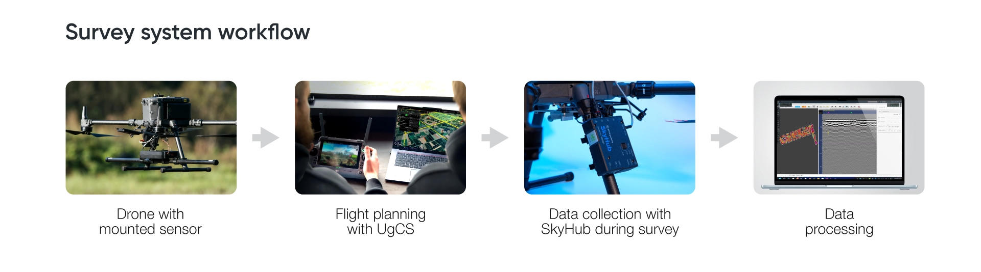
The sensor is one of five parts. A complete drone UXO detection system combines the magnetometer, a drone that can carry it, SkyHub for geotagged logging, laser-or-radar-based True Terrain Following, and UgCS flight planning.
Positioning deserves more attention than it usually gets. During the OSU test, weak LTE coverage interrupted RTK corrections. The flight lines drifted and sometimes overlapped, which complicated processing. The authors concluded that working RTK is essential for small UXO, because both the flight path and the altitude must be held exactly.
True Terrain Following keeps the sensor at a constant height over uneven ground. SkyHub handles logging for systems without their own recorder. UgCS plans the tight, evenly spaced lines magnetic surveys need. SPH's guide to planning drone magnetic surveys covers line spacing and run-off. For processing, SPH recommends GeoHammer Pro for quick field work and Seequent Oasis montaj for large projects. The Oasis montaj crash course is a practical starting point.
SPH supplies the complete system with training and support, and offers data processing in limited volumes to help customers set up their own workflows; it does not provide survey services.
The productivity case comes from the September 2024 Baloži comparison, which used 0.5 m sensor clearance, 1 m line spacing and a flight speed of 4 m/s. All three systems detected the same 10 of 11 buried targets, and the drone surveys took 37 minutes against 67 minutes on the ground. The ground survey needed three people and each drone survey two. The drones also held straighter, more parallel lines than the walking operator, an advantage that grows over large or rugged areas.
Before you buy
- Reprocess real data first. MagNIMBUS and each MagDrone system have published sample datasets from the GeoMIL UXO range and the Baloži test field, and the comparison reports link their raw data. Running them through your own software shows what your team can deliver.
- Confirm the ready-to-fly payload with every mount, cable and suspension line attached, especially for the R4.
- Build export licensing into the timeline where it applies.
- Check lead times. SPH lists 4 to 6 weeks for MagNIMBUS.
- Decide early whether you will run a base station. When the vertical gradient is the survey product, a gradiometer usually removes the need. For MagDrone systems, the SENSYS MagBase reference station cancels temporary noise such as passing vehicles or mains frequencies.
- Plan training for whoever will interpret the data. Every comparison report notes that what counts as a detection is the interpreter's judgment and changes with experience.
To get a configuration recommendation, send SPH your smallest target, its expected burial depth, the terrain and vegetation, the survey area, and the drone you fly. SPH can then specify the sensor, mounting, flight parameters, and processing workflow.
Frequently asked questions
Can a drone magnetometer detect landmines?
Only some types. Mines with a considerable amount of ferrous metal can be detected, but most modern landmines cannot. A magnetometer survey can support non-technical and technical survey by confirming ferrous items are present, but it can never confirm absence.
What height should I fly for a UXO survey?
As low as the target, terrain and safe operation allow. SPH's guidance usually puts sensor clearance under 1 m for UXO work. In the OSU test, MagNIMBUS identified 43 objects at 0.5 m and 57 at 0.2 m. That is an altitude comparison for one system, and tighter line spacing has to accompany any reduction in height.
Can a drone magnetometer find aluminum, copper or plastic pipes?
No. Magnetometers respond to ferrous material. Non-ferrous pipes stay invisible unless they carry current, and very thin-walled steel pipe can fall below detection. For non-ferrous utilities, drone GPR is the better-suited method.
Is a drone magnetometer survey faster than a ground survey?
In SPH Engineering's September 2024 comparison at 0.5 m clearance and 1 m line spacing, the drone survey took 37 minutes against 67 on the ground, with the same 10 of 11 targets detected. Results will vary with site size and terrain.
Do I need a magnetometer base station?
A base station records time-varying changes in the Earth's field so they can be removed from survey data. For vertical-gradient processing, simultaneous gradiometer measurements, such as those from the two-sensor MagNIMBUS, usually make it unnecessary, but still is advised to have when doing large-scale surveys such as mineral ore exploration. Single-sensor surveys, and surveys that deliver corrected total-field data, may still need one.