
Drone Geophysics for Ground Investigation and Geotechnical Site Assessment
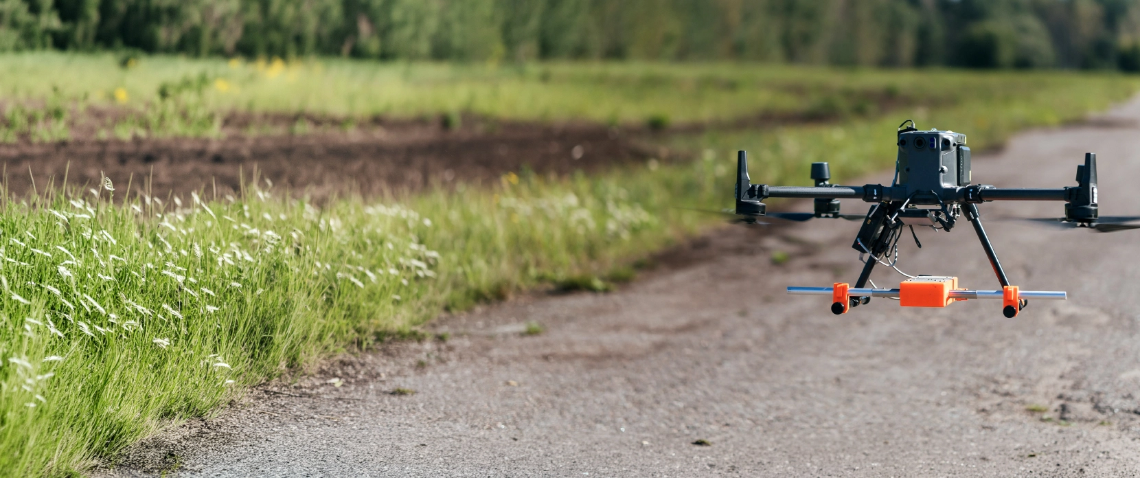
Drone-mounted ground penetrating radar (GPR) and magnetometers give geotechnical engineers continuous subsurface mapping data across a whole ground investigation site, covering the ground between boreholes. Plan line spacing and the altitude profile in UgCS against your own DEM, then hold antenna clearance over sloping ground with SkyHub True Terrain Following. Confirm data quality on site in GeoHammer, and convert two-way travel time into depth in Prism2, Geolitix, or Oasis montaj. SPH Engineering supplies the integrated geophysical survey system, the training, and support. You keep the capability in-house, and you know what is under the site before the rig arrives.
Non-destructive as-built verification on a live residential development: Zond Aero LF 300 confirmed 3.6 m retaining wall block depth with zero test boreholes
Universal GPR systems: the same Zond Aero unit flies on a drone or runs on a terrestrial cart
Field-proven on DJI M400, M350 RTK, M300 RTK, M600, Inspired Flight IF1200A, Harris Aerial H6, and Wispr Ranger Pro
Industry-standard processing: Prism2, Geolitix, GeoHammer, Magneto, Oasis montaj


Why Ground Investigation Still Surprises Geotechnical Engineers
Site investigation budgets get fixed before anyone knows what is actually down there. Boreholes and trial pits give accurate answers at a handful of points and say nothing about the space between them. A large share of earthworks overruns trace back to what was in those gaps.

Boreholes Sample Points, Not Areas
A typical investigation places boreholes tens of meters apart, and engineers interpolate everything in between. When rockhead rises 2 m over 15 m, or a peat lens sits between two logs, the piling contractor finds out before the report does.

Voids and Old Workings Surface Late
Karst features, backfilled quarries, shallow mine workings, and collapsed drainage runs tend to appear during excavation rather than during investigation. Low-frequency GPR screens the full footprint for cavities instead of relying on a borehole landing on one.

Ground Crews Cannot Safely Cover the Site
Cart and handheld geophysics needs an operator walking every survey line. Soft fill, contaminated land, steep batters, flooded ground, and live plant movement either stop the survey or put that operator at risk.

Terrestrial Geophysics Is Too Slow for Large Footprints
Terrestrial geophysical survey methods are slow at scale. Cart-based GPR runs below 1 m/s, and dragged or handheld setups are slower still. On a solar farm site, a highway corridor, or a greenfield development of tens of hectares, that becomes weeks of field time. Compare field days and annual costs for cart and drone GPR using your own survey areas.

Antenna Height Drift Destroys Subsurface Data
GPR penetration depends directly on antenna height above the surface, and magnetic anomaly amplitude falls off sharply with distance. Fly a fixed altitude above the take-off point across sloping ground and much of the dataset becomes unusable.

Buried Obstructions Stop Earthworks
Old foundations, steel tanks, cased wells, reinforcement, and ordnance all halt excavation when they are discovered by machine. Magnetometry maps ferrous targets across the site before the machines mobilize.
What a Drone-Based Geophysical Survey Adds to a Ground Investigation
A drone geophysical survey does not replace intrusive investigation. It tells you where to put the boreholes and fills in what happens between them, across the whole footprint, in a fraction of the field time.
Continuous Subsurface Mapping Across the Full Site
The drone flies a pre-programmed grid at a set line spacing and records a continuous radargram along every line. Instead of a scatter of point logs, you get a connected picture of layering across the site.
The drone flies a pre-programmed grid at a set line spacing and records a continuous radargram along every line. Instead of a scatter of point logs, you get a connected picture of layering across the site

Depth to Bedrock and Overburden Thickness Grids
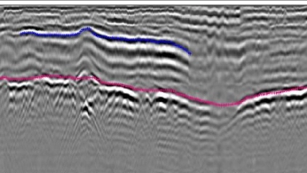
Low-frequency GPR answers the question geotechnical design turns on: depth to bedrock, how thick is the overburden and where does rockhead sit. Zond Aero LF reaches roughly 2 to 4 m from the drone at 300 MHz, 4 to 8 m at 150 MHz, and 7 to 10 m at 100 MHz in dry, low-conductivity ground. Processing software converts two-way travel time into depth and outputs thickness grids you can hand straight to the designer.
Void and Cavity Screening Without Ground Contact
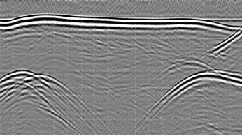
Cavity and sinkhole search is a standard application for Zond Aero systems from 600 MHz down to 100 MHz. Because the antenna never touches the ground, you can screen soft fill, unstable surfaces, and contaminated land that a cart cannot cross. Deliverables include vertical profiles, horizontal depth slices, and 3D reconstructions exportable to CAD and GIS.
Ferrous Obstruction Mapping Before Excavation
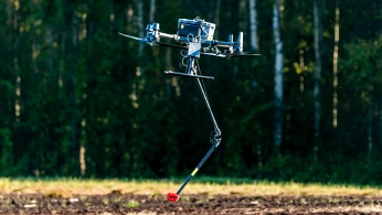
A drone magnetometer survey locates iron and steel structures such as old foundations with reinforcement, buried tanks, cased wells, steel pipes, and ordnance. With MagNIMBUS or MagDrone R1, flying at 1.5 m AGL puts the sensor 0.5 m from the surface, which is enough clearance to pick up small ferrous items. Oasis montaj and Magneto turn the anomaly map into target lists with depth and mass estimates your earthworks contractor can plan around.
Constant Antenna Height on Sloping and Uneven Ground
UgCS plans the mission against an imported DEM, and SkyHub with a laser or radar altimeter corrects altitude in real time from the actual surface below. On a site where the ground moves weekly from cut and fill, real-time correction matters more than a DEM captured a month ago. Consistent clearance means consistent penetration and lines that process cleanly.
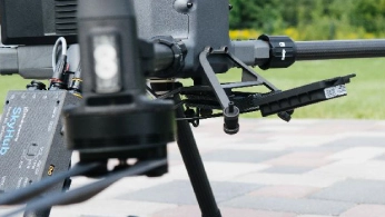
Non-Destructive As-Built Verification and Retaining Wall Inspection
Subsurface elements are hard to verify once they are built, particularly on near-vertical faces such as retaining wall inspection on completed structures. A developer used a Zond Aero LF 300 on a DJI M300 RTK with SkyHub to check retaining wall depth at heights up to 8 m, confirming 3.6 m block depth against design in Prism2. The verification was done from the air, without test boreholes or access equipment.
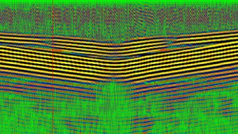
How a Drone Geophysical Survey Runs, Step by Step

Define the target, then pick the sensor and frequency
Start with expected depth, minimum target size, and soil type. Run those three inputs through the GPR Calculator to rule out any antenna that cannot reach your targets, then choose the highest frequency that still gets there. Higher frequency means better resolution and cleaner separation of closely spaced features. For a magnetic survey, the scoping inputs are expected target mass and depth, which set the line spacing needed for an anomaly to appear on more than one line.

Build the survey grid in UgCS
Import the ground investigation site boundary as KML or CSV and a DEM as GeoTIFF. Set line spacing, direction, speed, overshoot, and altitude profile in either AGL or AMSL, and let UgCS split long missions across batteries. The full mission is visualized in 3D before anyone leaves the office, and UgCS runs entirely offline once map and elevation data are cached.

Fly with True Terrain Following
SkyHub holds the antenna at a set clearance using a laser or radar altimeter and logs every trace with GNSS and altimeter readings. Recommended maximum antenna elevation is 0.6 m for Zond Aero 500 and 600, 1 m at 300 MHz, and 2 m at 150 MHz. The pilot monitors flight and data quality from a safe standoff.

Run field QC in GeoHammer before demobilizing
Load the raw file, trim takeoff, landing, and turn segments, and confirm subsurface reflections are actually present. Five minutes on site avoids a repeat mobilization. GPR acquisition follows the practice described in ASTM D6432, and outputs are supplied in formats that drop into a BS 5930 or Eurocode 7 ground investigation report.

Process, interpret, and hand over
Prism2 and Geolitix handle GPR processing: background removal, gain, depth calibration, filtering. Magneto and Oasis montaj handle magnetic data and target picking. Subsurface imaging outputs go out as vertical profiles, horizontal depth slices, thickness grids, 3D reconstructions, and GIS or CAD exports, with datasets stored and compared over time in DroneGIS.

Recommended Solutions for Geotechnical Surveys
GPR Kit
HARDWARE
Drone-based GPR system enables non-contact subsurface mapping of glaciers, buried utilities, and voids in areas inaccessible or unsafe for ground surveys.
SkyHub is a drone onboard computer that ensures reliable sensor integration and precise, synchronized data collection during every flight.
SOFTWARE

Desktop drone flight planning for the most demanding pilots.

Radsys GPR data processing software for Zond GPRs.

Assess & process GPR and other sensor data.
TRAINING

Advanced technical training and expert support to elevate your team’s expertise and ensure precise, efficient execution of your drone-mission tasks.
Magnetometer Kit
HARDWARE
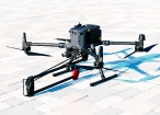
Drone magnetometers enable fast magnetic anomaly mapping for mineral exploration, UXO detection, and ferrous object localization over large areas.
SkyHub is a drone onboard computer that ensures reliable sensor integration and precise, synchronized data collection during every flight.
SOFTWARE
Desktop drone flight planning for the most demanding pilots.
Assess & process GPR and other sensor data.

Online GIS for Surveyors and Geophysicists.

Geophysical data processing and interpretation software.

Geophysical data processing and interpretation software (gravity/magnetics)
TRAINING
Advanced technical training and expert support to elevate your team’s expertise and ensure precise, efficient execution of your drone-mission tasks.


Why Geotechnical Engineers and Ground Investigation Contractors Choose Our Systems

13 years building drone geophysics systems
SPH Engineering has been integrating geophysical sensors with UAVs for ground investigation and geotechnical survey work from Latvia since 2013. Sensor integration, onboard computing, flight software, and pilot training are all built in-house.

Customers and partners in over 150 countries
Systems in the field across Europe, the Americas, Asia, and Africa, tested in Greenland, Iceland, Israel, Chile, and Papua New Guinea.

Our own geophysical sensor test range
We characterize sensors against known buried targets on our own test range before we recommend them. That is why we can tell you what a sensor will not do.

One GPR investment, airborne and terrestrial
Zond Aero systems are designed for both deployment modes. The unit that flies your greenfield site fits a cart for the confined sections of the same project.

Sensor-agnostic and platform-agnostic
UgCS supports over 20 drone platforms, and SkyHub integrates GPR, magnetometers, echo sounders, gamma-ray spectrometers, and more. We supply sensors and integration, not drones, so the recommendation follows the survey objective.

Training and support included, so the capability stays in-house
We do not sell geotechnical survey services. We deliver the system, train your team on installation, calibration, acquisition, and processing through SPH Academy, and support them afterwards. The billable work stays with you.

Trusted by






%202.svg)
_black%201.svg)





Insights on Drone-Based Ground Investigation
Watch Our Technical Webinars for Geotechnical Professionals

.webp)


Frequently Asked Questions
Can a drone geotechnical survey replace boreholes?
No, and you should not buy one on that basis. Geophysics gives you continuous coverage with interpreted results. Boreholes give you samples, in-situ testing, and ground truth at a point. The productive workflow runs the drone survey first, then places the boreholes on the anomalies and layer transitions the survey identified, which usually means fewer holes in better locations.
How deep can drone GPR see on a geotechnical site?
It depends on antenna frequency and ground conductivity. In dry, low-conductivity soils, penetration from a drone runs roughly 1 to 2 m at 500 or 600 MHz, 2 to 4 m at 300 MHz, 4 to 8 m at 150 MHz, and 7 to 10 m at 100 MHz. Because part of the pulse reflects off the surface before entering the ground, airborne penetration is typically around half of what the same antenna achieves ground-coupled. Dry sand can roughly double the range, and wet clay can cut it to almost nothing.
Can you detect voids and sinkholes from a drone?
Cavity and sinkhole search is a standard application for Zond Aero systems from 600 MHz down to 100 MHz. Detection depends on void size relative to depth: as a working rule, a reflector should be at least 10% of the antenna-to-target distance. Plan with margin rather than at the limit, and treat a clear result as a screening outcome, not a certification.
Does drone GPR work on clay soils or after rain?
Clay and clayey soils are among the worst mediums for GPR, and even a thin damp clay layer can block most of the signal. Saturated topsoil after rain has the same effect. On clay-dominated sites, schedule late in the dry season, or use magnetometry instead if the targets are ferrous.
Can I use the same GPR system for terrestrial surveys?
Yes. Zond Aero 500 NG, 600, and 1000 NG mount on drones and fit wheeled carts, and Zond Aero LF has monostatic and bi-static terrestrial survey kits. The unit, data format, and processing workflow stay effectively the same. That matters on projects with both an open greenfield area and confined sections around existing structures.
Which drones work with SPH Engineering's geotechnical systems?
SkyHub and the sensor payloads integrate with DJI M400, M350 RTK, M300 RTK, and M600, Inspired Flight IF1200A and IF800, Harris Aerial H6, Wispr Ranger Pro, and Cube or Pixhawk platforms running ArduCopter or PX4. Mounting hardware is included for supported models. SPH Engineering supplies the sensors, integration, and software, not the aircraft.
Does SPH Engineering carry out geotechnical surveys for clients?
No. We supply the complete system with training, certification, and support so your team runs the surveys. We do provide limited data processing assistance to help set up your workflow and transfer knowledge to your staff.
What deliverables come out of a drone geotechnical survey?
Standard GPR outputs are vertical profiles along each survey line, horizontal depth slices, thickness grids for overburden or layer thickness, and 3D reconstructions, all exportable to QGIS, ArcGIS, and CAD. Magnetic surveys produce anomaly maps and target lists with depth and mass estimates. Datasets can be stored, compared across survey dates, and shared through a browser in DroneGIS.
How do I choose between GPR and magnetometry for a site investigation?
Match the method to the target. GPR detects layer boundaries, voids, and both metallic and non-metallic objects, so it is the method for stratigraphy, rockhead, and cavities. Magnetometry only detects ferrous material, but it covers ground faster, works over vegetation better than GPR, and reaches large steel targets at several meters. On sites where both buried steel and unknown layering are concerns, running both over the same grid gives the most complete picture.
What can a drone magnetometer survey detect on a development site?
Iron and steel. Old foundations with reinforcement, buried tanks, cased wells, steel pipes, reinforcement mesh, and unexploded ordnance all produce magnetic anomalies a drone-mounted sensor can map. Magnetometry is blind to non-metallic targets, so it will not find a concrete duct, a clay pipe, or a layer boundary. Depth reach scales with target mass: a large steel tank shows at several meters, while a single small item only registers near the surface. Processing in Magneto or Oasis montaj turns the anomaly map into a target list with depth and mass estimates for the earthworks contractor.