Drone UXO Detection System.
Keep Your Team on Safe Ground.
Find Unexploded Ordnance From Air.
Complete drone magnetometry system for unexploded ordnance (UXO) detection. Sensor, flight planning, laser terrain following, onboard data logging, data processing, and training. One vendor. Tested and proven against real ordnance.
6 hours to survey 6 hectares and locate a buried WW2 artillery shell
~1 ha/hour survey speed, single sensor, 1m line spacing
0 people in the hazard zone during the survey

What This System Delivers
Scans the terrain your crew can't walk on
Mudflats, slopes, shorelines, and heavily contaminated areas. The drone doesn't care.
Survey up to ~1 hectare per hour
Single sensor, 1m spacing. 5-10x faster than other types of UXO detection.
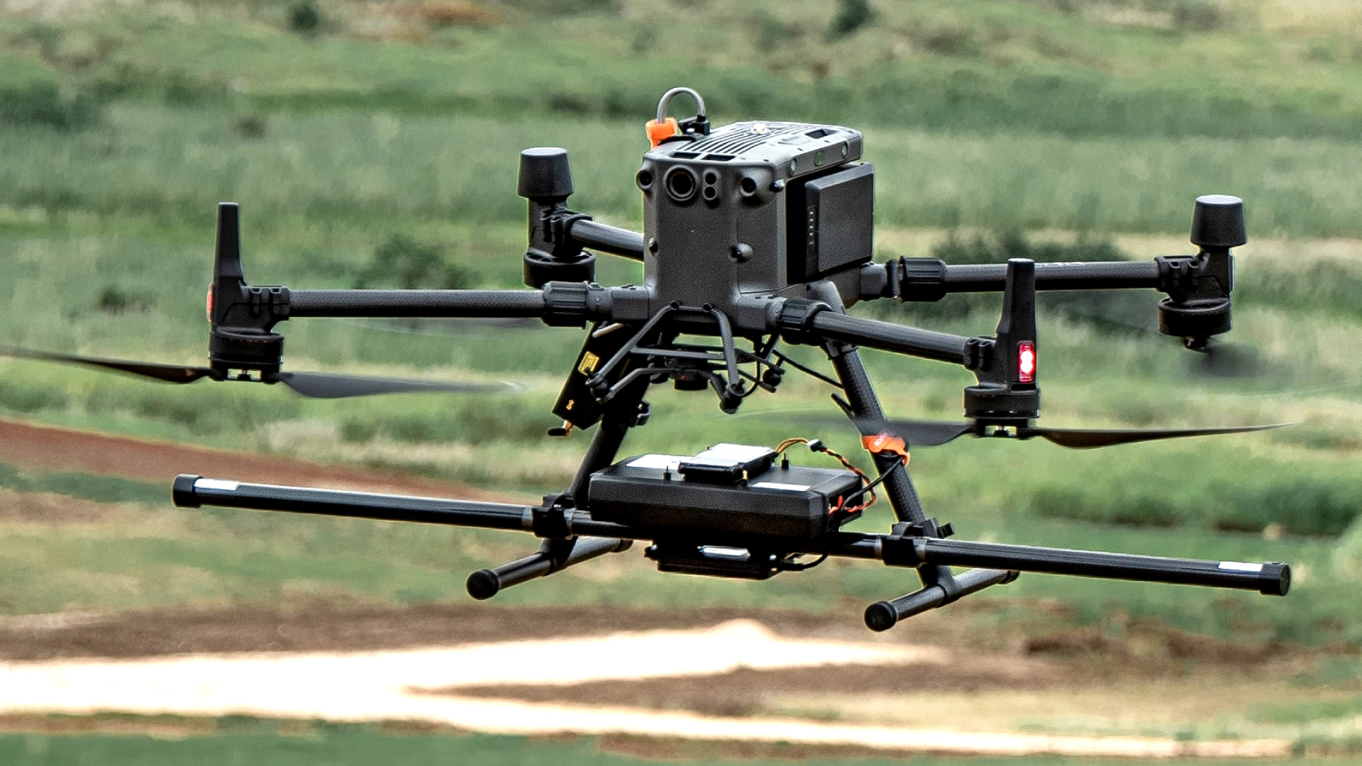
20cm sensor clearance
Lower than any suspended system. SPH Engineering’s MagNIMBUS or SENSYS MagDrone R1 foldable arm absorbs ground contact. At 0.2m, nearly 3x more detections than at 1.0m.
RTK coordinates per anomaly
Output: georeferenced map with the exact position of every detected object. Ground teams dig at marked points.
Anomaly map in minutes after landing
Process on your laptop in the field. Decisions are made on-site, not days later at the office.
The Complete Drone System for UXO Detection Surveys
HARDWARE
Drone magnetometers enable fast magnetic anomaly mapping for mineral exploration, UXO detection, and ferrous object localization over large areas.
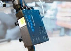
SkyHub is a drone onboard computer that ensures reliable sensor integration and precise, synchronized data collection during every flight.
SOFTWARE

Desktop drone flight planning for the most demanding pilots.

Assess & process GPR and other sensor data.

Online GIS for Surveyors and Geophysicists.

Geophysical data processing and interpretation software.

Geophysical data processing and interpretation software (gravity/magnetics)
TRAINING

Advanced technical training and expert support to elevate your team’s expertise and ensure precise, efficient execution of your drone-mission tasks.
How Our Drone UXO Detection System Works
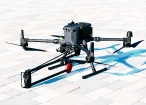
MagNIMBUS clips to the drone
Connect SkyHub and the laser or radar altimeter. Under 15 minutes.
Import the survey boundary into UgCS.
Parallel lines generated at your spacing. Set altitude, speed. Upload to the drone. No internet connection needed.
Fly Automated mission.
Altimeter holds exact height over every terrain change. SkyHub logs magnetometer data with RTK GPS.
Transfer data. Process in minutes.
Output: magnetic anomaly map and list of the targets with GPS coordinates for every detected ferrous object.
Hand coordinates to the ground team.
They go to specific marked points. The drone found it. The team confirms, extracts and renders safe.
.jpg)


Webinar Recordings

.webp)


FAQs
What is drone-based UXO detection?
A drone flies low over a survey area carrying a magnetometer sensor that measures disturbances in the Earth's magnetic field. Buried ferrous objects (shells, bombs, shrapnel, mortar rounds) create measurable anomalies. After the flight, the data is processed into a georeferenced map with GPS coordinates for every detected object. A ground team then investigates only the marked locations. The drone does not remove or detonate anything. It tells you where to dig.
How fast can a drone survey a site for unexploded ordnance?
Approximately 1 hectare per hour with a single-sensor magnetometer at standard UXO parameters (0.5m to 1.0m line spacing, 1-2 m/s flight speed). A dual-sensor setup like the SENSYS MagDrone R3 can cut that time roughly in half. In a real field deployment in Latvia, SPH Engineering surveyed a 6-hectare farm field in 6 hours, including a 76mm WW2 artillery shell found at 30cm depth. Foot-based magnetometer crews typically cover 1-2 hectares per day, making drone surveys roughly 5-10x faster.
How deep can a drone magnetometer detect buried UXO?
It depends on the object's size and ferrous mass. Large items like aerial bombs produce detectable anomalies at several meters distance between the sensor and the target. Mid-size ordnance like 105mm shells can be detected at approximately 1.5-2.5m. Small items like hand grenades are detectable at roughly 0.5m. These are sensor-to-target distances, so actual detection depth from the surface equals the detection range minus the flight altitude. Flying lower always improves results: in the Oklahoma State University controlled test, MagNIMBUS detected 57 targets at 0.2m altitude versus 20 targets at 1.0m over the same field. SPH Engineering publishes a full detection distance reference table by ordnance type on its website.
What types of sites are suitable for a drone UXO survey?
Open terrain with relatively low vegetation works best: farmland, grassland, coastal areas, mudflats, shorelines, cleared construction sites, and desert. Drones are particularly valuable for sites that are difficult or dangerous to access on foot, such as suspected minefields, flooded areas, steep slopes, and heavily contaminated zones. Performance decreases in areas with tall, dense vegetation (forests), significant metallic debris (scrapyards, industrial sites), or strong electromagnetic interference (directly under high-voltage power lines, near railways). Urban and built-up areas are generally not suitable for drone magnetometry due to the density of ferrous infrastructure.
What tools are needed for UXO detection surveys?
A complete drone UXO detection system consists of five components: a magnetometer sensor (such as the MagNIMBUS atomic total-field magnetometer or SENSYS MagDrone R1/R3/R4 fluxgate), a drone capable of carrying the sensor (DJI M400, M350 RTK is the most common platform), an onboard computer for geotagged data logging (SkyHub), a laser-based terrain following system to maintain precise altitude above ground (True Terrain Following), and flight planning software to design and execute automated survey missions (UgCS). Data processing after the flight is typically done in Geosoft Oasis Montaj or similar geophysical software. SPH Engineering is the only vendor that provides the magnetometer, onboard computer, terrain following, flight planning, and training as a single integrated system.
What are the advantages of UXO detection surveys using drone magnetometry over other methods?
Zero personnel in the hazard zone during the survey. The drone enters the suspected area, the operator stays at a safe distance. This is the primary reason demining organizations and survey firms worldwide have adopted drone magnetometry for the non-technical survey (NTS) and technical survey (TS) stages of the land release process.
Beyond safety: drone surveys are 5-10x faster than foot-based methods, cover terrain that ground crews cannot access, produce RTK-geotagged anomaly maps with precise coordinates for every target, and deliver repeatable results because the automated flight path can be re-flown with identical parameters. The cost per hectare drops significantly on large survey areas because one pilot and one drone replace a multi-person ground crew. Most drone UXO operations worldwide already run on SPH Engineering technology.