

The argument over whether drones belong in powerline inspection ended a few years ago. Drone powerline inspection is now standard practice across many major grids. The interesting question now is which kind of drone inspection fits which job, and where the workflow actually breaks down.
In our work with utilities and survey providers across Europe, Latin America, North America, and Asia, the answer rarely depends on the aircraft itself. It depends on what type of inspection a team is running, what payload makes sense for that inspection, and how the data gets turned into a report someone in operations can act on. Get those three decisions right and a drone program will pay for itself. Get any of them wrong and you end up with thousands of images nobody opens.
This guide walks through the decisions that matter, the workflows our customers use with UgCS for both corridor and fine inspections, and the points where most programs get stuck.
What Is a Powerline Inspection Drone?
A powerline inspection drone is any UAV configured to capture detailed condition data on transmission or distribution infrastructure. It's also called a utility drone inspection platform when described by the job rather than the hardware. The aircraft is rarely the specialized part. Most utility programs fly standard commercial multirotors, the same airframes used for mapping and survey work. What turns one into an inspection platform is the combination of payload, flight planning software, and a data workflow.
Start with the payload. High-resolution RGB handles visible defects, thermal picks up overheating components, and LiDAR builds the point cloud for vegetation and sag analysis. UV cameras exist for corona detection but stay a specialist case. The airframe's job is to carry whichever of these the inspection calls for, fly stably close to structures, and run a flight controller the planning software can talk to.
Flight planning software is the part that makes any of this repeatable. It lets your crew fly the same corridor or the same tower the same way every cycle, so the data from this quarter lines up with last quarter's instead of drifting with whoever held the controller. Without that, you have aerial photos. With it, you have a dataset you can compare over time.
Why Utilities Are Switching to Drones
The shift to drones is being driven by three things, in roughly this order of importance.
Safety
A drone replaces the data collection step on a tower climb or a helicopter sortie. The crew still has to climb for actual maintenance work, but the inspection itself no longer requires anyone to work near live conductors, hang from a structure, or run a low-altitude helicopter. For utilities running thousands of inspections a year, the cumulative reduction in exposure is the strongest internal argument for the program.
Speed
A planned mission flies itself the same way every time, so the data comes back on a schedule instead of depending on the pilot's day. In processing, defect-detection tools flag the likely problems first, which means engineers review candidates rather than scroll through every frame. Crews that hold BVLOS approval cover much more line per sortie than a visual-line-of-sight operation can, because a VLOS crew has to keep the aircraft within sight and relaunch from a new position every stretch, while a BVLOS crew flies the corridor in one continuous run.
Lower operating cost
Helicopter sorties carry pilot, fuel, and mobilization costs that drones avoid. Climbing crews need traffic control, trucks, and time. Drones move much of that expense to compact crews, software tools, and standardized workflows. The savings show up unevenly: large transmission inspections often save the most, while small-scale distribution work is closer to a wash unless the program runs at high volume.
Corridor vs Fine Inspection
Transmission and distribution don't get flown the same way. Transmission work is corridor-driven, with high-voltage towers and long spans between structures. For distribution inspection (poles, lower-voltage lines, urban and suburban networks), the asset density is higher and the individual structures are smaller. Distribution work, with its denser and smaller assets, is often a better fit for higher-cadence pole-by-pole capture, while transmission work usually needs LiDAR and a structured corridor mission.
The right drone and the right software are not the same for both. Underneath that split sit two distinct inspection jobs that share an aircraft.
- Aerial corridor inspection: These cover long stretches of transmission and distribution lines along with the vegetation around them. Most outages that trace back to vegetation are due to trees growing into the conductor, limbs falling during a storm, or even hazard trees leaning toward the line. This work suits LiDAR. A single crew running a LiDAR corridor survey covers a meaningful stretch of line in a day, and the post-flight data compiles inside a few hours rather than the weeks a comparable helicopter or photogrammetry product takes.
- Fine inspection: This is the close-range examination of individual towers, conductors, insulators, dampers, and fittings. The focus here is resolution on each component, not the kilometers of line per day. A fine-inspection flight might cover a handful of towers in the time a corridor survey covers tens, because the drone is working each structure from several angles instead of passing it once.
Corridor work and fine inspection run on incompatible flight logic. Corridor work prioritizes coverage and clean LiDAR returns at a steady altitude, and fine inspection prioritizes precise camera position around each component. Serving both in one mission means either thinning corridor coverage or skipping the angles that catch a hairline crack, so they're planned and flown separately even on the same site visit.
Drones vs Helicopters vs Foot Patrols for Powerline Inspections
Drones did not replace the older inspection methods. They slotted between them. Foot patrols remain the cheapest option per kilometer for short, accessible distribution lines and for follow-up checks on a specific asset a crew is already near. Helicopter surveys are still cost-competitive on very long transmission corridors above roughly 1,000 km in a single mobilization, where their speed offsets the per-hour cost. Drones occupy the broad middle, and the middle is where most utility inspection work actually happens.
Two operational advantages of drones are not obvious from a cost-per-kilometer comparison. The first is weather flexibility. Helicopter surveys get grounded by weather conditions that a properly rated drone can fly through, which means a drone team can deploy on the day a windstorm passes through and a helicopter operator is still waiting for clearance. The second is mobilization. A drone crew with two pilots and a vehicle can be on a corridor within hours. Helicopter mobilization usually takes days.
This is why drones have started winning public tenders against helicopters in Europe, particularly for vegetation management and routine corridor inspection. They typically cost less per corridor than a helicopter program, the data quality holds up for the analysis utilities actually run, and the wider weather window closes inspection backlogs faster.
Vegetation management is the application driving most of this. Power outages caused by tree contact and falling limbs are the dominant failure mode on most transmission and distribution networks. In dry regions, vegetation contact is also the leading cause of utility-related wildfire ignition, which has turned routine vegetation surveys from a maintenance line item into a regulatory and legal priority. LiDAR drones produce the kind of classified point cloud and predictive vegetation model that supports both maintenance planning and the documentation regulators increasingly require.
Powerline Inspection Sensors
No single payload catches every defect. A cracked insulator shows up on RGB, a failing connection only shows up on thermal, and vegetation clearance needs LiDAR. So the sensor question is really a defect question: list what you need to find, and the payload picks itself. You can use this matrix to set up a new program.
UV cameras for corona detection stay a specialist payload that most teams never need. If you do need one, plan on a dedicated mission and dedicated training: the cameras and the workflow are not the same as visual or thermal.
For corridor work that has to deliver vegetation clearance reports, LiDAR beats photogrammetry since RGB cameras struggle to penetrate canopy.
Thermal is the one teams skip and regret. Visual imagery alone misses a category of defects (loose connections, overloaded circuits, failing insulators) that show up clearly on IR but produce no visible artifact at all. A combined RGB plus thermal payload like the DJI Zenmuse H30T or H20T is the standard configuration because it catches both defect categories in one pass.
Multirotor vs Fixed-Wing for Powerline Inspection
For most utility inspection work, multirotor platforms are the right tool. They hover, sit close to a tower, fly safely at low altitude, and handle the small clearings utilities have for take-off and landing along an easement.
Fixed-wing aircraft still hold an advantage in two specific situations: very long corridors (hundreds of kilometers in a single deployment) and route planning surveys before construction. What you give up are fixed-wing platforms cannot hover, they fly at higher safe altitudes, carry smaller payloads, and their airspeed during capture introduces motion blur that limits which defects you can detect.
One platform trait that doesn't show up on a spec sheet until it costs you a flight is electromagnetic tolerance. Ultra-high-voltage lines above 400 kV distort compass readings and can disrupt GNSS reception and the flight controller itself, which is why enterprise inspection platforms carry shielding and redundant navigation. On the highest-voltage corridors, confirm the aircraft is rated to fly close to energized conductors before you plan tight passes around them.
One platform trait that doesn't show up on a spec sheet until it costs you a flight is electromagnetic tolerance. Ultra-high-voltage lines above 400 kV distort compass readings and can disrupt GNSS reception and the flight controller itself, which is why enterprise inspection platforms carry shielding and redundant navigation. On the highest-voltage corridors, confirm the aircraft is rated to fly close to energized conductors before you plan tight passes around them.
UgCS supports both aircraft types, and most of our utility customers run multirotors (DJI M400, M350 RTK, M300 RTK, M30T) for line inspection and reserve fixed-wing for greenfield route surveys. If a US-based program needs to comply with federal procurement rules, UgCS works with NDAA-compliant platforms including Harris Aerial, Inspired Flight, Freefly, and others.
The UgCS Powerline Inspection Workflow
Most of the value in flight planning shows up before anyone drives to the field. A mission planned well gets flown once, re-flown the same way next cycle, and produces data the processing software can ingest without manual cleanup. A mission planned badly costs that time back twice, in the field and again at the desk.
Corridor and fine inspection share the first two steps, then split:
1. Import the line geometry
Customers usually hand over tower coordinates as CSV or KML. UgCS imports both directly and lets you trace the line across as many waypoints as the route needs. Multi-waypoint editing (select all, then bulk-edit speed, altitude, turn type, or actions) saves the hours you'd otherwise spend adjusting points one at a time.
2. Plan against real terrain
UgCS ships with an SRTM elevation database that's fine for flat or gently rolling ground. For mountainous corridors, or anywhere the ground drops sharply between towers, import the actual DEM (PRO, EXPERT, and ENTERPRISE accept custom elevation models). The elevation profile view shows your planned path against the terrain, so you catch a too-low altitude over a ridge before the drone does.
From here the two jobs diverge.
For corridor missions
- Use the LiDAR Corridor tool: Set corridor width, altitude mode, flight altitude, and sensor field of view, and UgCS generates the passes needed to cover it. Point density follows from altitude, speed, and sensor rather than a number you type, so set those with your density target in mind. Change the width and the pass count adjusts on its own.
- Plan IMU calibration into the route: UgCS includes figure-eight and U-shape calibration patterns you drop directly into the flight path, so calibration happens in the air instead of as a separate setup step on the ground.
- Plan True Terrain Following where the terrain warrants it: TTF holds the drone at a set height above ground from real-time radar readings rather than a stored DEM. Over uneven ground or low vegetation, it keeps point density far more consistent than DEM-based planning.
- Set ground control points where you need survey-grade accuracy. For corridor mapping that only informs vegetation management, RTK plus the processing software is enough. For deliverables tied to a survey accuracy spec, GCPs aren't optional.
For fine inspection missions
- Set GSD relative to the asset, not the ground: For most work, ground sample distance is set against ground level. For close-range tower work, set it against the conductor or the structure itself, and raise the route altitude to match tower height so the resolution you get at the asset is the resolution you planned for, not whatever the terrain dictates.
- Control the camera and the recording window: UgCS exposes gimbal control along the route (nadir, oblique, custom), and you can attach start- and stop-recording actions to specific waypoints. For tower-by-tower video, start recording before the tower and stop after it. Hours of unusable footage is the second-most common waste in a powerline program. The first is uncalibrated LiDAR.
Pre-Flight Checklist for Powerline Drone Inspections
Three reminders that experienced pilots already know but every new drone team forgets at least once.
- Comply with local UAV regulations and check whether the inspection itself needs a separate permission: In most countries the rules are on the website of the local civil aviation authority. In some regions, aerial photography over critical infrastructure also needs its own clearance, separate from the flight permit. Check both before mobilizing the crew.
- Confirm the site conditions match what the satellite imagery showed: Most missions get planned in the office using Google Maps or Bing satellite imagery that may be one to three years old. Take-off and landing points may need to shift on the day to clear obstacles the imagery doesn't show: tall trees, masts, temporary structures, or new construction. Walk the site before launching.
- Check telemetry reception at the planned take-off point: Modern inspection drones geotag each image onboard during the flight, so image position depends on a clean GNSS/RTK fix at the aircraft. A weak or obstructed signal degrades that fix and leaves you with image positions you can't trust. Plan an alternate take-off and operating area where reception stays solid.
These three checks are crucial for UAV powerline inspections. For more things to check, read our comprehensive pre-flight checklist for commercial drone operators.
Powerline Inspection Data Processing
Flying the mission is the easy part. Whether the program succeeds or fails gets decided later, in data processing and reporting.
For LiDAR corridor work, the processing software classifies the point cloud into the categories that matter for utility analysis, such as power lines, transmission towers, vegetation, ground, and structures. From there the software runs vegetation encroachment analysis, scissor crossing checks, wire sag modeling, and wind effect simulations.
AI-assisted defect detection is now standard in the better processing tools, flagging cracked insulators, hardware deformation, and vegetation encroachment automatically so analysts can spend their time on the candidate issues instead of scrolling through thousands of clean frames.
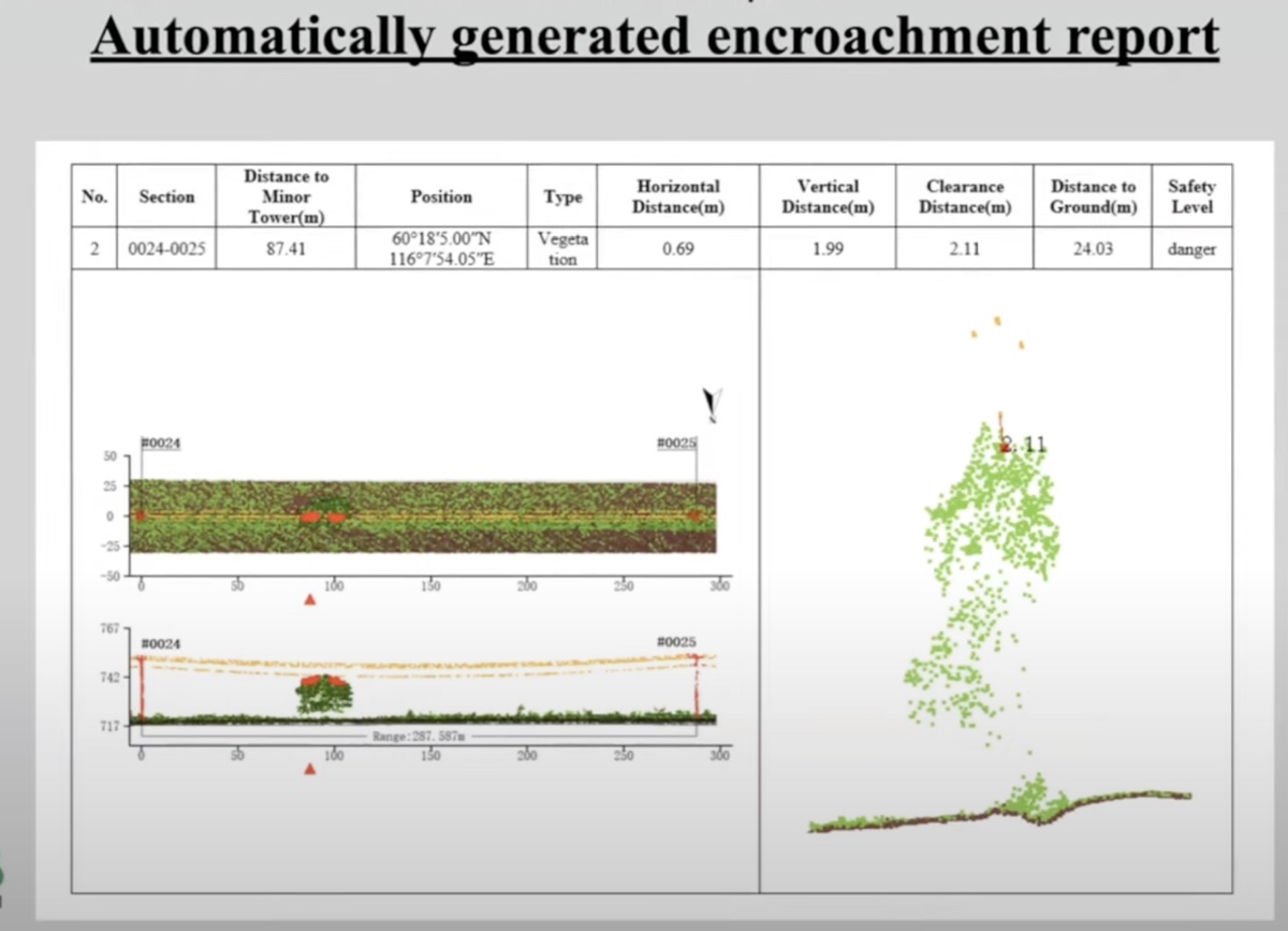
Predictive modeling of tree growth and tree fall risk is what changes the economic argument. Instead of inspecting the same corridor every quarter to catch issues after they appear, you inspect annually and use the model to predict where issues will appear in the next twelve to eighteen months. Software like LiPowerline, GreenValley International's product suite, integrates directly into this workflow and produces the HTML and PDF reports operations teams actually read.
For fine inspection, the LiDAR data has a different role. Once the corridor scan is complete, the point cloud is fed back into the planning software to generate camera positions for the next visit: where exactly the drone needs to sit to capture each component of each tower in high resolution. The fine inspection becomes a programmatic flight rather than a pilot trying to remember which angles they need.
The hidden cost in any inspection program is not the flight or the sensors. It is the time it takes to convert thousands of images into a defect report someone can act on. This is where most internal drone programs underestimate effort, and it is the bottleneck that keeps utilities outsourcing what they would prefer to handle in-house.
Powerline inspection is rarely a one-shot job. The same corridor gets flown every quarter, every year, or every storm season. Once the first inspection is processed, the resulting GeoTiff map can be imported back into UgCS as a map layer for the next mission. The next flight plans against actual imagery from the previous cycle, not just the satellite basemap, which means the take-off points, the obstacle locations, and the asset coordinates are all current. This is how a powerline inspection program turns into a repeating asset rather than a series of one-off surveys.
Our joint webinar with Green Valley International walks through the full LiDAR-to-report pipeline using LiPowerline. If you want to see the workflow, the recording below is the closest thing to a live demonstration.
Limitations of Drone Powerline Inspection
Drones do not replace every form of powerline inspection. The earlier comparison table covered the corridor-length crossover point with helicopters. Here are two more limits worth naming.
Contact work still needs a crew
Any inspection that requires a hand on energized hardware still puts someone on the structure. The drone collects the data; the crew does the maintenance. That split doesn't change, no matter how capable the aircraft gets.
Regulations and labor cost
In regions with weak BVLOS frameworks or restrictive airspace, a drone program's reach is capped regardless of the equipment. Europe is adopting fast because the regulatory and economic pressure push the same way. Elsewhere the barrier is labor cost: across much of Latin America and many developing markets, paying a ground crew to walk the line is still cheaper than running a drone program. That gap, not the technology, is what holds adoption back. It will shift as drone costs fall, but it hasn't flipped everywhere yet.
What a Drone Powerline Inspection Program Costs
There are two ways to run powerline inspections: contract them out, or build the capability in-house. The cost structures look nothing alike, and the choice between them comes down to how often you fly.
Outsourcing is priced per mile of corridor or per structure. Rates vary with sensor configuration, terrain, and reporting depth, but these are the ranges to plan against:
Add mobilization, lodging, and travel for any job that takes the team off its home base.
An in-house program front-loads the cost into equipment and training, then runs cheaper per inspection from there:
These are ballpark figures for a European or North American program. Hardware costs are fairly global, but training, labor, and licensing vary enough by country to move the totals. Multi-aircraft fleets scale close to linearly on hardware, with software cost rising more slowly per added pilot.
Training is the line teams underestimate most. Flying the drone is the easy part. Reading the data, classifying defects against a utility's asset standards, and turning that into a report operations can act on takes months to get good at. Budget for the analyst's learning curve, not just the pilot's.
Where the in-house case wins depends on frequency. Programs tend to pay off somewhere around 8 to 12 corridor inspections a year, earlier if the utility runs storm-response inspections a contractor can't mobilize for fast enough.
The Future of Drone Powerline Inspections
Two trends shape what a serious drone power line inspection program looks like today.
The first is automation. At European utilities especially, internal drone teams aren't adding people. The same crews are getting through more work, with pre-planned missions and more software-assisted defect detection. And the time saved goes into the inspection backlog rather than into new hires.
The second is the integration of inspection data into asset management. A drone inspection used to end as a PDF report attached to an email. Now the deliverable is structured data: a classified point cloud and a defect list that feed straight into a digital twin, an asset register, or a maintenance scheduler.
The drone program that does not deliver structured data integrated into the rest of the operation is going to lose the next procurement cycle to one that does. SPH Engineering's DroneGIS platform handles the data management side of this for the teams that need it.
If you are setting up a powerline drone program, or rethinking one that has stalled, the questions worth asking in this order are: what type of inspection are we actually running, what payload matches the defects we need to find, how will the data turn into a report, and how does that report integrate into the rest of the operation. Get those four right and the aircraft choice almost takes care of itself.
Talk to us if you want help building or improving the workflow. We help with software and hardware selection, mission planning setup, data processing and reporting pipelines, and training.
Frequently Asked Questions on UAV Powerline Inspections
Do drone inspections require shutting down the power line?
Most do not. Visual, thermal, and LiDAR inspections are routinely flown over energized lines using drones rated for electromagnetic interference and operated at safe clearance distances. The point of using a drone is precisely to avoid the planned outages traditional climbing inspections would have required. Some specialized inspections (very close-range component examination, work that involves landing on a structure) may still need the line to be de-energized, but those are exceptions rather than the rule.
How much does a drone powerline inspection cost?
Outsourced inspections typically run $300 to $2,000 per mile of transmission corridor or $150 to $500 per individual tower or pole, depending on sensor configuration, terrain, and reporting depth. An in-house program costs roughly $25,000 to $50,000 in startup capital plus $10,000 to $20,000 per year to operate. The breakeven against contracting is usually around 8 to 12 inspections per year.
What sensors are used for powerline inspections?
The four common payloads are high-resolution RGB cameras for visual condition, thermal (IR) cameras for hotspots and overheating components, LiDAR for 3D point clouds and vegetation clearance analysis, and UV cameras for corona discharge detection. Most inspection programs run RGB plus thermal as the standard combination, with LiDAR added for corridor work and UV reserved for specialist applications.
Can drones inspect powerlines in bad weather?
Most professional inspection drones are rated for moderate wind and light precipitation. The DJI M350 RTK and similar enterprise platforms carry IP55 weather ratings and operate reliably in conditions that ground a helicopter. Heavy rain, snow, sustained high winds, and temperatures outside the manufacturer's range will still keep a drone on the ground. For utilities, the practical advantage is that the operating window is wider than for crewed aircraft, which is one reason post-storm assessments have become a strong drone use case.
What training do operators need?
In the United States, an FAA Part 107 Remote Pilot Certificate is the legal minimum for commercial operation. In the European Union, EASA Open or Specific Category certification is the equivalent baseline. Most utilities require additional safety training for working near energized infrastructure, plus sensor-specific training for thermography and LiDAR processing. Plan on $1,500 to $5,000 per operator for the full training stack.
Is aerial utility inspection the same as drone powerline inspection?
In practice, yes. Aerial utility inspection is the umbrella term covering any utility infrastructure flown from the air, including gas pipelines and water networks. Drone powerline inspection is that category applied to electrical transmission and distribution, and it's the most mature subset of the field today.
What's the difference between aerial corridor inspection and fine inspection?
Aerial corridor inspection (sometimes called transmission line inspection) covers long stretches of line and the vegetation around them, usually with LiDAR, looking for clearance issues, sag, and tree contact risk.
Fine inspection is close-range examination of individual towers and components using RGB and thermal imagery, looking for cracked insulators, corroded hardware, and hotspots. The two missions have different flight planning logic and should be flown as separate flights even when the team is on the same site.
Do drone powerline inspections meet regulatory documentation requirements?
In most jurisdictions, yes, though the specifics vary. Drone-collected RGB and thermal imagery, geotagged and tied to specific assets, generally meets the same documentation standards as helicopter or ground-collected imagery. Vegetation clearance reports based on classified LiDAR point clouds are accepted by most utility regulators where vegetation management is an audited program, including in the United States, parts of Canada, Europe, and Australia. Always confirm specifics with the relevant authority for the work being documented.