Drones have quickly become established as one of the tools used for powerline inspections. They are much faster and cost-efficient compared to traditional inspection methods. Combined with a LiDAR and a camera, they can be used for the following applications:
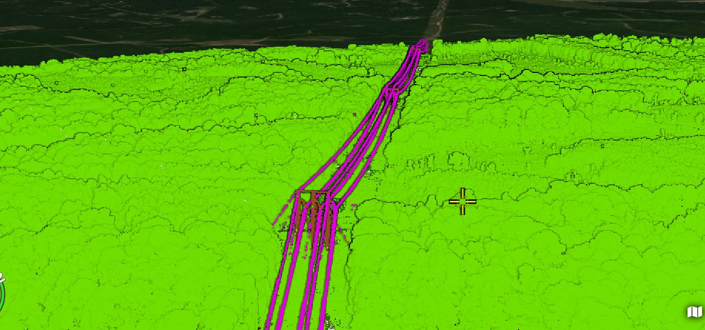
- Vegetation encroachment analysis - LiDAR is a very effective tool for analyzing vegetation encroachment of powerlines. It makes it possible to measure the distance between powerlines and vegetation, allowing to proactively manage it to prevent outages or fires.
- Topographical data collection - topographical data gathered using LiDAR is important for planning new powerline routes, assessing risks of landslides and erosions, and understanding the impact of environmental factors.
- Elevation spot check - to comply with regulations, powerlines have to be hung at a safe height over terrain. Data collected in drone LiDAR inspections allows to easily measure the sag as well as check the structural integrity of poles and towers.
Drone models used for powerline LiDAR surveys
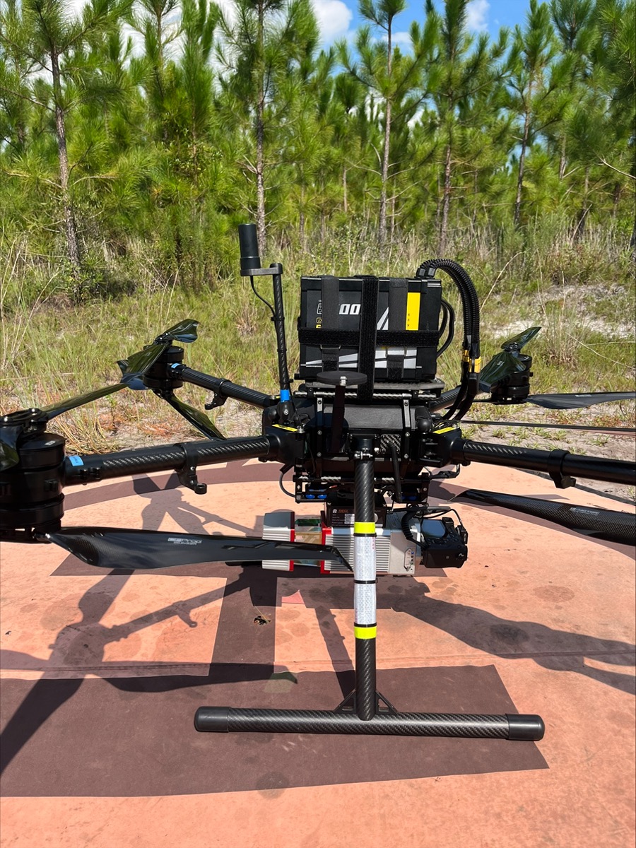
LiDAR surveys require drones capable of lifting a payload of at least around 2.5 kgs. Some of the most popular drones used for these types of applications are the DJI M300 RTK and the recently released updated version - M350 RTK.
While these have become the workhorses of the industry, in the last few years, due to regulation changes, many drone operators and service providers in the public sector have been moving to using drones that are NDAA Compliant, Remote-ID enabled, and made in the USA. Typically, these drones run either a version of Ardupilot, PX4, or Auterion (PX4 flight stack) on their autopilots.
In this case, the company has selected to use two different drone models. For longer corridor inspections, the Harris Aerial hybrid drones are used. While normal drones would typically require a battery change for performing these long types of missions, the Harris Aerial has a flight time of up to 2.5 hours, allowing it to get the job done without having to land multiple times in the middle.
The other drone model used is the Watts Innovations Prism, which is a lighter battery-powered drone but also well-suited for LiDAR missions. The Watts can be used in areas where smaller topographical surveys need to be performed.
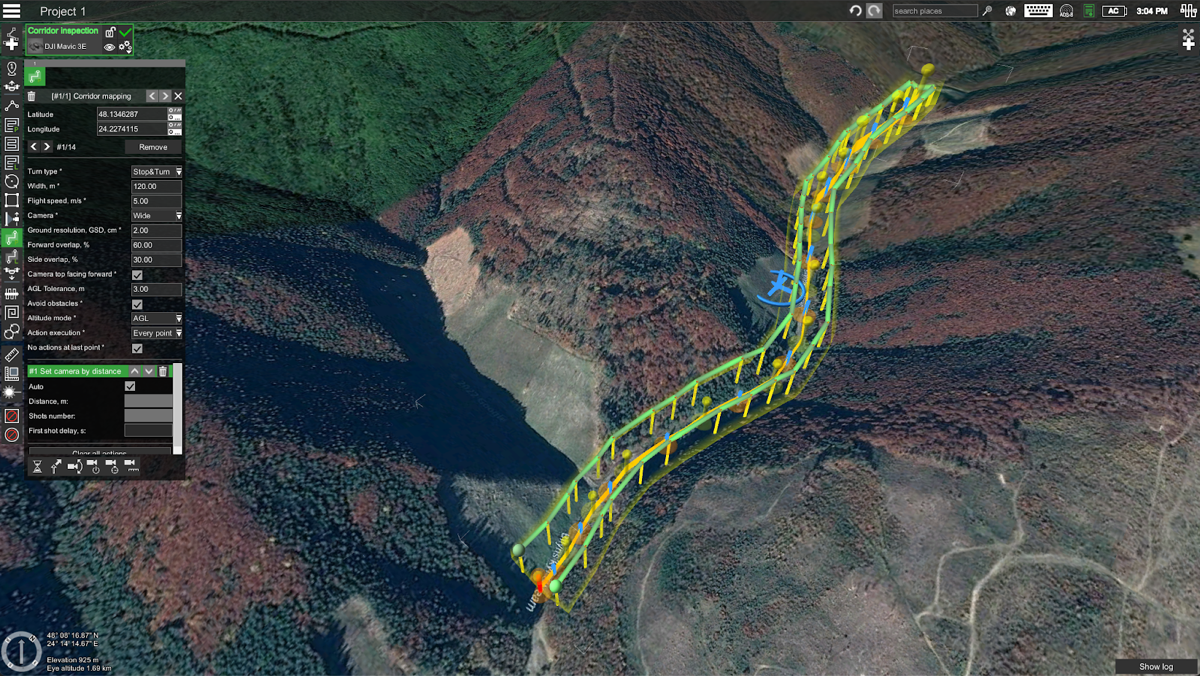
Both of these drones - the Harris and the Watts are supported by UgCS flight planning software.
The recent update to LiDAR tools in UgCS allows utilizing them along with other drones such as Freefly Astro, Inspired Flight, and others on LiDAR missions. Moreover, drone operators flying both - DJI and NDAA-compliant drones can easily share flight plans within their team and use UgCS as a single flight planning solution for different drone platforms.
In parallel with many drone service providers transitioning to NDAA-compliant drones like Freefly and Watts for public sector projects, the field of LiDAR is experiencing rapid growth. This expansion reflects a trend toward automating various business aspects.
However, a significant challenge has emerged: these advanced drones often lack a robust flight planning solution. This is where UgCS comes into play. UgCS adeptly fills this gap by enabling effective planning of LiDAR surveys, specifically with American-made drones.
The importance of this capability cannot be overstated, as the quality of the collected LiDAR data heavily relies on the precision of the flight plan. Without a well-designed flight plan, the data may not meet the required standards for accuracy and detail. Hence, UgCS stands as the go-to software for maximizing the potential of LiDAR technology in drone operations, ensuring that service providers can fully leverage their capabilities in an increasingly automated and precision-focused industry.
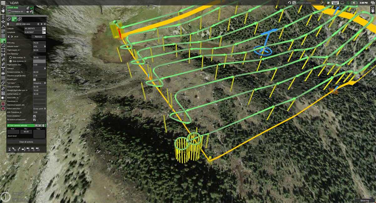
UgCS allows planning LiDAR flights using FOV angle, automatic IMU calibration patterns, and other adjustable parameters such as area buffer size, overshoot segments, adjustable corner radius, and more.
Payloads used in LiDAR surveys
One of the most affordable drone LiDAR sensors in the market is the DJI L1 (soon to be replaced by the updated DJI L2). While these sensors provide just enough for pilots to get started on doing various surveying jobs, they are often not enough in terms of precision when compared to more expensive LiDAR sensors.
For powerline inspections with the Watts Prism drones, the Riegl miniVUX 1UAV LiDAR sensor has been selected along with a Sony A6000 RGB camera. This combination allows to collect precise topographical data as well as a dense colorized point-cloud around powerline corridor. The resulting data is used for monitoring vegetation encroachment and clearance height measurements.
Any LiDAR sensor can be used with UgCS flight planning software for data collection. The only sensor-specific parameter needed is the FOV angle.