

UgCS Large Projects lets you define the full survey area once, set the project parameters, and then split it into subareas that can actually be flown. The subareas share the same core project settings instead of being planned as unrelated missions. sphengineering.com
Start here
- Watch: Introduction to Large Projects in UgCS
Watch the YouTube Video - We Solved Large Drone Mission Problem - Learn the Complete Workflow
Read the Drone Magnetic Survey Planning Guide - Build Your Own Large Project
Download UgCS
Who are Large Projects for?
Large Projects was introduced specifically for magnetic surveys over large areas. SPH Engineering's current workflow is aimed at geophysical survey contractors, mineral exploration and oil & gas teams, UXO operators, and researchers running aeromagnetic work.
It makes most sense when:
- the survey requires many flights;
- grid continuity between those flights matters;
- tie lines need to stay consistent across the site;
- multiple take-off locations are required;
- terrain makes low-altitude planning more complex;
- or the site will be revisited for repeat or infill acquisition.
Large Projects is available in UgCS Expert and UgCS Enterprise.
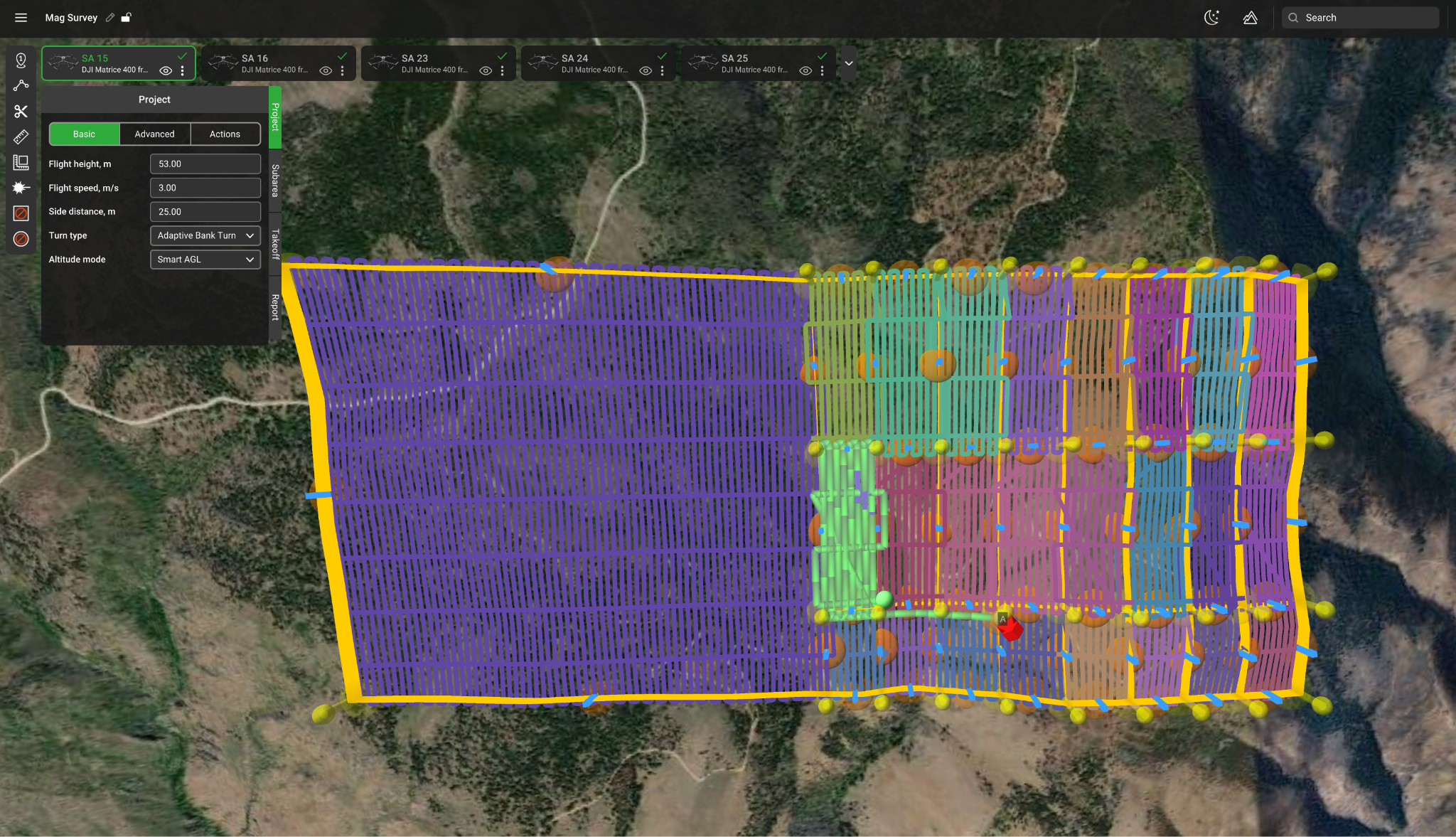
One survey instead of dozens of separate flight plans
Large survey areas are usually too big for a single battery or take-off location.
With Large Projects, you import or draw the full project boundary, add take-off locations and divide the site with cut lines into manageable subareas. Each subarea can then be sized around expected flight time and field logistics.
The important part is that you are still planning one survey.
Flight speed, flight altitude and line spacing come from the project settings, rather than being recreated independently for every block.
Split the project. Keep the grid consistent.
Splitting a large magnetic survey into flights creates another problem: continuity between those flights.
UgCS keeps the survey structure consistent across the subareas. Adjacent subareas can also be planned with overlap to maintain data continuity between flight blocks.
That means the site can be divided around batteries, access and take-off locations without manually rebuilding the grid every time.
Tie lines are part of the project
Tie lines are used to assess consistency across magnetic survey data and support tie-line levelling.
In Large Projects, the tie-line frequency is configured at project level. UgCS then maintains the tie-line structure across the survey grid instead of requiring a separate manually constructed validation grid.
For example, you can specify one tie line for every five survey lines and apply that structure across the project.
Plan repeat and infill surveys against previous work
Large Projects also supports workflows where a site needs to be surveyed again.
UgCS can use previous survey lines as a reference and shift the new grid to align with an earlier campaign. This is useful for higher-resolution follow-up surveys and other cases where new line positions need to correspond with previous data. The official Large Projects webinar demonstrates this with the Shift Right workflow.
Deal with terrain before you reach the site
Large magnetic surveys are often flown at relatively low AGL over uneven terrain.
UgCS supports custom high-resolution DEM import for terrain-aware flight planning, together with elevation-profile review and configurable AGL tolerance. DSM data can also be imported to help operators preview surface features such as vegetation and buildings, but it is not used to calculate flight altitude.
Maps and elevation can also be cached for offline use before travelling to sites with limited connectivity.
One survey. However many flights it takes.
That is the point of Large Projects.
Define the survey once. Split it into practical flights. Keep the grid, tie lines and project settings together.