
They built a custom spray drone and flew it over real vines three times across a growing season, once early, once mid-season, once late, testing five different spray amounts each time. That is 45 flights in total, all flown along the same vine row, so the only thing changing between flights was the spray setting itself.
Keeping everything else identical was the hard part, and it is where UgCS drone flight planning software came in. Two things made the comparison possible:
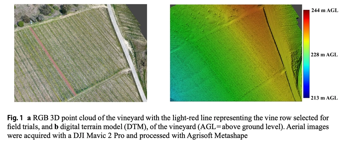
- UgCS held the drone at the same height above the ground on every flight, even though the ground and the vine canopy both changed shape along the row. The team imported a digital terrain model (DTM) of the vineyard into UgCS and used terrain following to adjust the drone's altitude on the fly to keep it a steady 2.70 meters above the ground level.
- UgCS kept the spray nozzles pointed the right way. Using waypoint heading control, UgCS automatically rotated the aircraft's nose to match its direction of travel, so the two nozzles, mounted at a fixed angle to spray into the canopy, stayed aimed at the row instead of drifting off to one side.
Because the flight itself stayed identical every time, any difference the researchers measured afterward, in how much spray landed on the leaves versus the ground, could be traced back to the spray setting being tested, not to variation in how the drone flew.
The same two precision agriculture capabilities reach well beyond vineyards. Any mission that needs to hold a steady height and heading over a repeating, linear target, tree rows in an orchard, hedgerows, pipeline or powerline corridors, or other row-based spraying and sensing work, can run on the same UgCS setup this study relied on.
Researchers tested five spray amounts across a vineyard's growing season and found that using more spray mostly added runoff, not results. UgCS kept the spray drone flying at a steady height and heading for all 45 test flights.
Institution: Department of Agricultural, Forest and Food Sciences (DiSAFA), University of Turin (UNITO), Italy.
Key Results
- Using more spray mostly added waste, not results. Ground losses more than tripled as spray volume went up, while the amount actually reaching the canopy barely changed once adjusted for volume.
- The best spray setting changed with every growth stage. Researchers found a different ideal setting for early, middle, and late season rather than one setting that worked all year.
- UgCS held the drone at a steady 2.70 meters above ground level on every one of 45 flights, using a pre-loaded terrain map and automatic direction correction to keep the nozzles aimed at the vines.
- The canopy-targeted spray method avoided over-wetting the leaves at every setting tested, across the entire season.
Why Vineyard Drone Spraying Needed Stage-by-Stage Data
European law under Article 9(1) of Directive 2009/128/EC, the Sustainable Use of Pesticodes Directive, currently bans spraying pesticide from the air. A drone sprayer can only get an exemption if someone proves it does no more harm to people and the environment than the ground equipment it would replace.
That proof is hard to produce for vineyards specifically. Vine canopies sit in narrow, vertical rows with bare soil in between, not the flat, continuous fields most spray drones were designed for. Nobody had published stage-by-stage data on how a canopy-targeted spray drone performs as a vine canopy fills in over a season, from thin spring growth to a dense, ripening canopy.
The University of Turin ran the test that gap needed. Across three grapevine growth stages, researchers tried five spray amounts and measured exactly where the liquid ended up: on the leaves, on the ground, or missed entirely.
Why Ground-Sprayer Volume Guidance Does Not Transfer to Drones
Steep-slope vineyards are some of the hardest crops to spray safely, a point the researchers raise directly in their introduction. Tractor sprayers on slopes carry a known rollover risk, and where the ground is too rough for a tractor, crews often spray by hand, with direct skin and inhalation exposure to pesticide.
Existing tools for choosing a spray volume were built for ground-based sprayers that push spray sideways into the canopy from the inter-row path. A drone sprayer works differently: it flies above the canopy and pushes spray down through rotor downwash, which changes how droplets travel and where they land. None of that ground-sprayer guidance transfers directly.
On top of that, most spray drones were built for broadcast spraying in open fields, flying overlapping passes across a continuous target. A vineyard row is a narrow, vertical strip of canopy with open gaps on either side, so a broadcast mindset risks wasting spray on bare ground instead of vines.
How UgCS Terrain Following Removed Flight Variation From the Trial
Height and heading consistency mattered here specifically because the vineyard was not flat, and the vines themselves grew taller as the season went on.
Without a steady flight height and heading on every pass, differences in spray deposit or ground loss could just as easily have come from an inconsistent flight as from the actual spray setting being tested. UgCS's job was to remove that variable. It did not choose the nozzle size, spray pressure, or application rate. Those were the researchers' experimental variables, tested across five separate combinations.
Drone, Nozzles, and Application Rates Tested
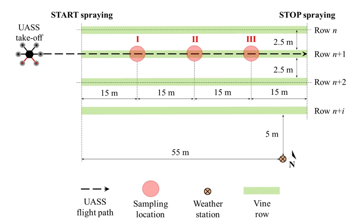
- Site: Vineyard in Castagnole Monferrato, Asti, Italy. Cultivar Ruché, vertical shoot position-trellised, Guyot-pruned, planting density 5,000 vines/ha (0.8 m vine spacing, 2.5 m row spacing). One 60 m vine row used, with three vines spaced 15 m apart as biological replicates.
- Growth stages (BBCH scale, a standard code for plant development): BBCH 55, early, inflorescences swelling; BBCH 75, middle, berries pea-sized; BBCH 81, late, berries beginning to color.
- Aircraft: DJI Matrice 600 Pro hexacopter with a D-RTK GNSS receiver, configured as an unmanned aerial spraying system (UASS), carrying a custom 3.0 kg spray kit: a 10 L diamond-shaped polyethylene tank, two nozzle holders, and a dedicated diaphragm pump per nozzle.
- Nozzles: Two 30-degree prototype narrow-spray hollow-cone nozzles (ASJ, Italy), modified from a standard 60-degree design to hold pressure at the narrower angle.
- Application rates tested: 54.2, 72.9, 90.6, 105.8, and 142.2 L/ha, achieved with ISO nozzle sizes 015, 02, 025, 03, and 04. Pressure was 0.30 MPa for the four smaller sizes; the ISO 04 nozzle ran at 0.25 MPa because of pump capacity limits.
- Flight speed: constant 1.5 m/s (5.4 km/h).
- Trial design: each of the five application rates repeated three times per growth stage, for 15 flights per stage and 45 flights total.
- Tracer: Tartrazine yellow dye (E102) at 10 g/L in the spray mixture, extracted from samples with deionized water and measured by absorbance at 427 nm.
- Sampling: filter papers on upper and lower leaf sides measured canopy deposit (4 to 9 sampling points per vine, depending on canopy size at each growth stage). Water-sensitive papers measured spray coverage and coverage density. Plastic Petri dishes on the ground, at the row center and at 0.63 m and 1.25 m to either side, measured in-field ground losses: spray reaching the soil under and beside the treated row, distinct from airborne drift downwind, which this study did not measure.
- Analysis: linear mixed-effects models in R tested growth stage and application rate effects. A combined scoring model (TOPSIS) weighed canopy deposit, ground losses, spray coverage, and coverage density together, giving canopy deposit the heaviest weight, to pick one recommended setting per growth stage.
What 45 Flights Showed About Spray Volume and Ground Loss
- More spray didn't mean more reached the vines: Canopy deposition went up as researchers used more liquid, but once they adjusted for the amount used, the difference nearly disappeared. The canopy set the real limit on how much spray could be retained
- Ground losses kept climbing: Every time the team raised the spray rate, more liquid ended up on the soil under and beside the row instead of on the vines. Adding volume made the spraying less efficient.
- The middle of the season lost the most spray to the ground: As the canopy grew taller during the season, it moved closer to the drone's fixed flying height, which the researchers think pushed more spray toward the soil. Later in the season, a denser canopy caught more of the spray before it reached the ground.
- Spray coverage went up, but never oversaturated the leaves: Coverage on the leaves increased with more spray, yet the leaves rarely got wet enough to count as over-sprayed by industry standards, at any setting or growth stage.
- More liquid didn't always mean denser coverage: The setting that produced the most spray droplets per leaf changed depending on the growth stage.
- The best setting changed every time the season moved forward: When the team combined all four measurements into one score, a different spray rate came out on top for each growth stage: the lowest rate early in the season, a middle rate mid-season, and the highest rate late in the season. That ranking held up well even when the researchers changed how much weight they gave each measurement, except for the late-season pick, which shifted toward the lowest rate if ground loss was treated as the top priority.
Limits of the Study and What the EU Rule Change Would Require
The authors are upfront that these are not universal settings. The trial ran at a single site, on a single cultivar (Ruché), with one drone platform, one nozzle set, and one fixed flight height, so the recommended rates apply to that tested setup, not to every vineyard or every spray drone.
The study measured where the spray physically landed, not whether it actually controlled pests or disease. The authors note that connecting these coverage numbers to real pest control would need separate, dedicated field trials.
The EU is also considering a rule change that could allow exemptions for vineyard drone spraying, conditional on proving equal or lower risk than ground equipment. Stage-resolved data like this is the kind of evidence regulators are expected to want before approving specific drone spray systems for that use.
Source: Mozzanini, E., Biglia, A., Gioelli, F., Sopegno, A., Maritano, V., Messina, C., Gay, P., & Grella, M. (2026). Comparison of low-volume spray application rates using UASS: implications for vine canopy deposition, spray quality, and in-field ground losses. Precision Agriculture, 27, Article 107. https://doi.org/10.1007/s11119-026-10407-9. Published online July 6, 2026. Peer-reviewed, open access under CC BY 4.0.
Research funded by: PRIN 2022 PNRR call for proposals, Project “3E-UAVspray,” project code P2022SS9TF, CUP J53D23018580001, funded by the European Union – Next Generation EU. Open-access costs covered by the University of Turin under the CRUI-CARE Agreement.

