

Rivers are among the harder environments to measure reliably. Banks are often inaccessible, the water can be unsafe to enter during the high flows that matter most, and many catchments have no permanent gauging station at all. Between 2023 and 2026 the UAWOS project, a Horizon Europe consortium led by the Technical University of Denmark in which SPH Engineering is the payload integration partner, worked to close that gap with contactless, drone-mounted sensing. This article summarises what those campaigns have established and what they mean in practice. The full datasets, surveying protocols, and peer-reviewed publications remain on the UAWOS project site, linked at the end.
The measurement problem rivers pose

Discharge cannot be read from the bank. A wide river may be shallow, and a narrow one may carry more water through a deeper, faster channel. To quantify how much water a river actually moves, several variables are needed together: how wide and deep the channel is, how fast the water travels, and how the water surface behaves along the reach.
Traditional in-water methods answer those questions but require contact with the water. A manual cross-section can involve 20 to 25 measurement verticals, and approaches such as acoustic Doppler profiling or tracer dilution still need a crew on or in the river. During floods this becomes slow, dangerous, or impossible, which is precisely when the data is most useful.
Satellites help but do not solve it. The SWOT mission (NASA and CNES, with the Canadian and UK space agencies, launched December 2022) maps water surface elevation and width across wide swaths using a Ka-band radar interferometer. It mainly observes the surface: it does not measure channel depth or flow velocity, and it resolves rivers roughly wider than 100 metres, so smaller rivers and finer detail fall below its reach.
This is the gap UAV hydrometry fills. A drone flies close enough to measure depth and velocity directly, and is mobile enough to reach banks and reaches that ground crews cannot.
Four variables, four drone payloads
UAS hydrometry, as developed in UAWOS and commercialised by SPH Engineering, captures the hydrometric picture with four drone-mounted payloads. Each is integrated through SPH Engineering's SkyHub onboard computer and flown with UgCS, which holds the aircraft at a constant height above the water using true terrain following.
- Water surface elevation. A drone-borne radar altimeter maps water surface elevation continuously along a reach, including the subtle differences that ground spot-readings miss.
- Riverbed geometry (bathymetry). An echo sounder or a water-penetrating radar surveys the channel cross-section beneath the surface. The two methods suit different water conditions, so the choice is site-dependent.
- Surface velocity. A Doppler radar measures how fast the surface is moving across the channel.
- Discharge. Combining surface elevation, bathymetry and surface velocity through the SPH hydrometric workflow yields discharge in cubic metres per second. Airborne discharge is reported to be on the order of 15 percent less accurate than in-water measurement, with the gap narrowing on larger rivers, in exchange for keeping the crew off the water.
Satellites, drones and models for ungauged rivers
For a river with no gauging station, no single instrument is enough. UAWOS combines three layers: SWOT surface observations along the reach, UAV measurements at key cross-sections, and a coupled hydrological-hydraulic model that reconstructs flow between those snapshots using satellite rainfall and temperature data.
On the Oueme River in Benin, a catchment without ground monitoring, this combination produced discharge estimates that were tested against the available records. Over the validation period the project reported model performance of NSE 0.85 and KGE 0.71, two standard goodness-of-fit metrics where values closer to 1 indicate closer agreement with observations.
Why BVLOS changes the economics of a river campaign
Most of the cost in a river survey is not the flying. The UAWOS cost model breaks a campaign into five parts: planning, travel and accommodation, equipment, survey execution, and data processing. Moving from visual-line-of-sight (VLOS) to beyond-visual-line-of-sight (BVLOS) operation changes three of them.
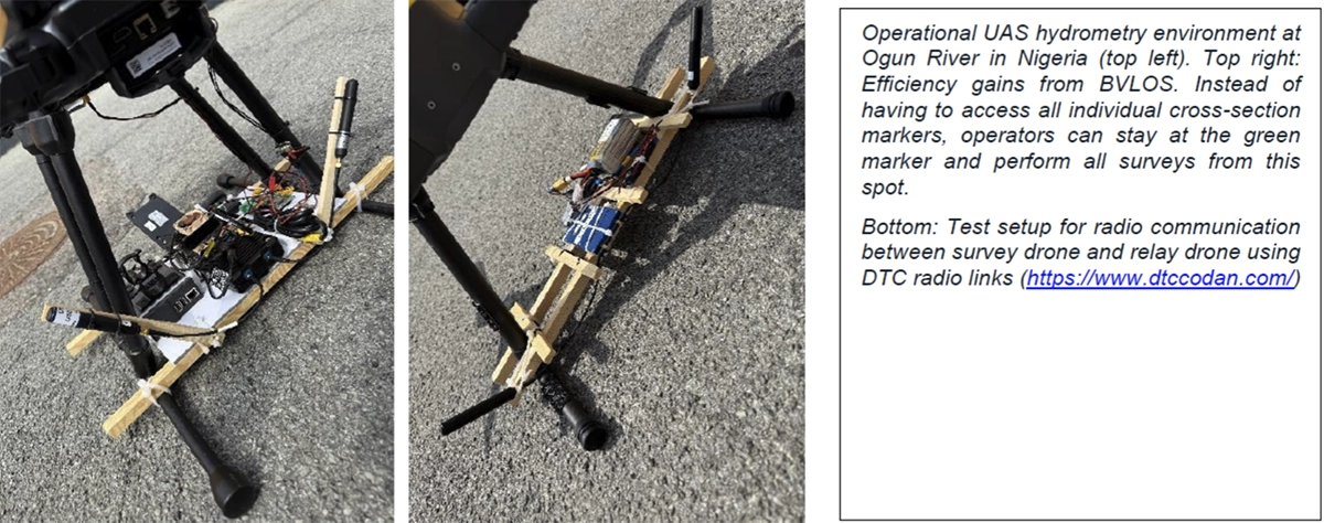
- Planning. VLOS requires a launch point within sight of every cross-section, which often means negotiating access across several landowners. BVLOS lets a survey run from a few accessible hubs, cutting planning hours and administrative friction.
- Equipment. BVLOS adds hardware: relay drones, communication relays, and additional battery and charging capacity, which raises the initial equipment footprint.
- Survey execution. A single BVLOS take-off can sweep multiple cross-sections in one continuous flight rather than packing up and relocating between each, which lowers the cost per cross-section and per kilometre of surveyed reach.
- Travel, accommodation and data processing. These are largely the same in both modes, so they form the stable baseline of a campaign budget.
The first BVLOS river campaign under this model is planned for the Isar River in Germany.
Field validation across Europe and Africa
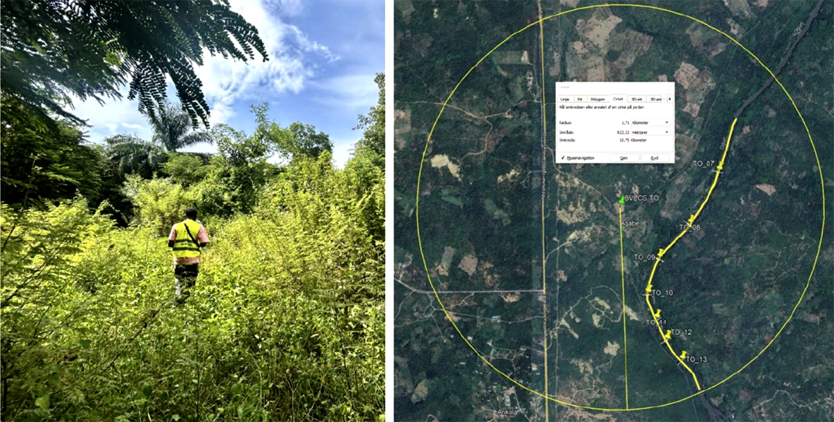
The approach has been tested in eight surveys across six rivers in Europe and Africa: the Ronne (Sweden), Isar (Germany), Orco and Po (Italy), Torne (Sweden and Finland), Oueme (Benin) and Ogun (Nigeria). Every dataset includes ground-truth benchmarks and is published openly at three processing levels, from raw data to data projected onto the river centreline.
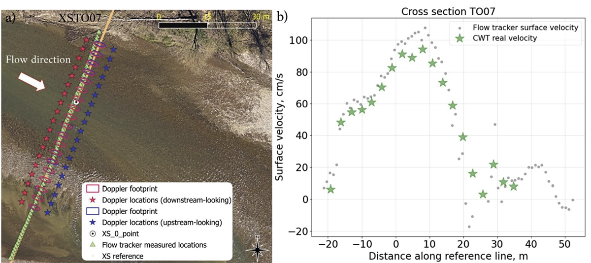
- Orco River. Radar altimetry resolved the elevation difference between two river braids caused by the river's riffle-pool structure, and Doppler surface velocimetry was compared against FlowTracker ground-truth measurements.
- Torne River. Combining SWOT water surface elevation profiles, UAS hydrometry and hydraulic modelling, the project estimated peak flow during a 100-year flood event in May 2023 to within a few percent of reference, validated independently with ICESat-2 data.
Commercial adoption

Demand for drone-integrated hydrometric payloads has grown alongside the project's field demonstrations, particularly for echo sounders and water-penetrating radar, with the first commercial entries of radar altimeter and Doppler radar payloads following the demonstration phase. With over 100 echo sounders, 85 water penetrating radars, 3 altimeter radars and 2 doppler radars sold during the Post-Demonstration Phase of UAWOS Project.
Access the data and the protocols
The full UAWOS datasets, surveying workflows and publications are openly available through the project site and data repository. SPH Engineering supplies and integrates the hydrometry payloads referenced here.
If you manage rivers, reservoirs or water bodies that are difficult or unsafe to survey from the ground, a short call with our specialists can establish whether UAV hydrometry fits your site and which payload configuration applies.
Explore the open datasets and protocols at uawos.dtu.dk.