Hydrometry is the science of measuring water levels, flow rates, and discharge in rivers, lakes, streams, and other water bodies.
Specialized sensors such as ground penetrating radar, echosounder and doppler radar make it possible to collect accurate data about water quantity and movement. This information allows to make informed decisions for managing water resources, flood predictions, irrigation planning and conducting environmental studies.
Traditional river hydrometry methods rely on fixed measurement stations equipped with tools like staff gauges or mechanical current meters. These stations can provide accurate long-term data but are expensive to install and maintain, and they’re limited to locations with existing infrastructure such as bridges or dams. Even modern tools like Acoustic Doppler Current Profilers (ADCPs), which use sound waves to measure water flow, still require trained operators, boats, and favorable conditions to function properly. This makes it challenging to collect data quickly in remote or hard-to-access areas.
SPH Hydrometric drone solutions make it possible to conduct hydrometric surveys quickly, even on large or difficult to access water bodies in remote locations.
And we will tell you how to implement a drone based hydrometry solution for your application

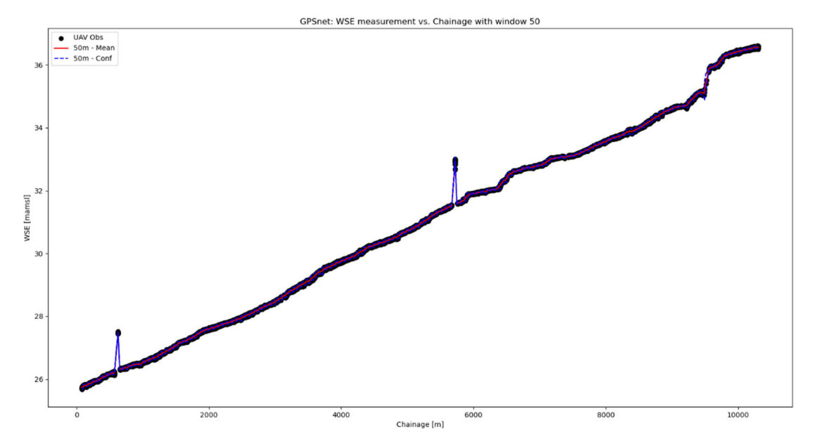
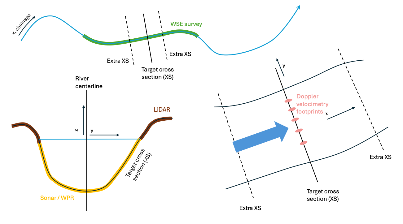
In a drone water surface elevation (WSE) survey an RTK GPS-equipped drone flies along the centerline of the river. The water level sensor mounted on the drone measures the distance to the water surface. From this data gathered the water surface elevation profile can be extracted. Typical flight height for this survey is around 35 meters.
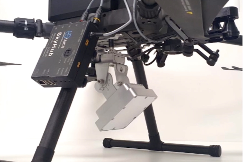
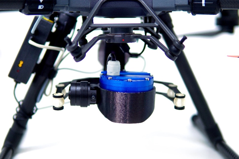
Geolux LX-80 mounted on a 3-axis gimbal
Staff gauges / pressure transducers, RTK-GPS boat surveys. Stationary water level radar level meters.
Raw radar sensor data, GNSS data from drone and base station (for PPK mode surveys).
<1m spatial resolution along river centerline with an accuracy of 3 cm or better.
1.5 - 4.5 km/hour.
Easier ability to access remote or challenging areas.
Flood prediction and management, irrigation planning, water resource management.
CSV file with water surface elevation data along the chainage of a river.

Riverbed elevation surveys consist of two parts - mapping the dry part of the river using LiDAR and mapping the underwater part of the river using a GPR or an echosounder (depending on conditions one or the other can be more suitable).
Traditional methods involve deploying teams on either sides of the rider and moving a bathymetric sensor from one side to the other or doing surveys by boat, which are often inaccurate, expensive or not possible in shallow rivers.
LiDAR point-cloud, GPR/Echosounder data, GNSS data from drone and base station (for PPK mode surveys)
10 cm or better
Lower cost compared to manned surveys. Rapid deployment in field, even in hard-to-reach areas and shallow rivers.
Creation of hydraulic models for flood forecasting and infrastructure planning. Input for river discharge monitoring.
Merged dataset with LiDAR and GPR/Echosounder measurements

Aerial river velocity survey requires covering each chosen river cross-section using a flight path planned at an offset upstream from the cross section. The survey method involves hovering every two meters for at least 20 seconds with the doppler radar facing the cross section.
Manual wading through the water using probes / sensors or boat surveys. Stationary doppler radar sensors deployed on bridges or monitoring stations. There is also a new method - visual velocimetry but it relies on tracking visible tracers or surface patterns in video footage. It is limited by poor lighting, surface glare and lack of trackable features in the water.
10 cm/s or better
0.75-1.5 cross sections per hour
Works even without trackable features on the water surface, doesn’t require illumination or video stabilization and allows for processing velocity estimates in real time (post-processing required for the precise data reporting).
Creation of hydraulic models for flood forecasting and infrastructure planning. Input for river discharge monitoring.
Processed doppler radargram of a cross section.

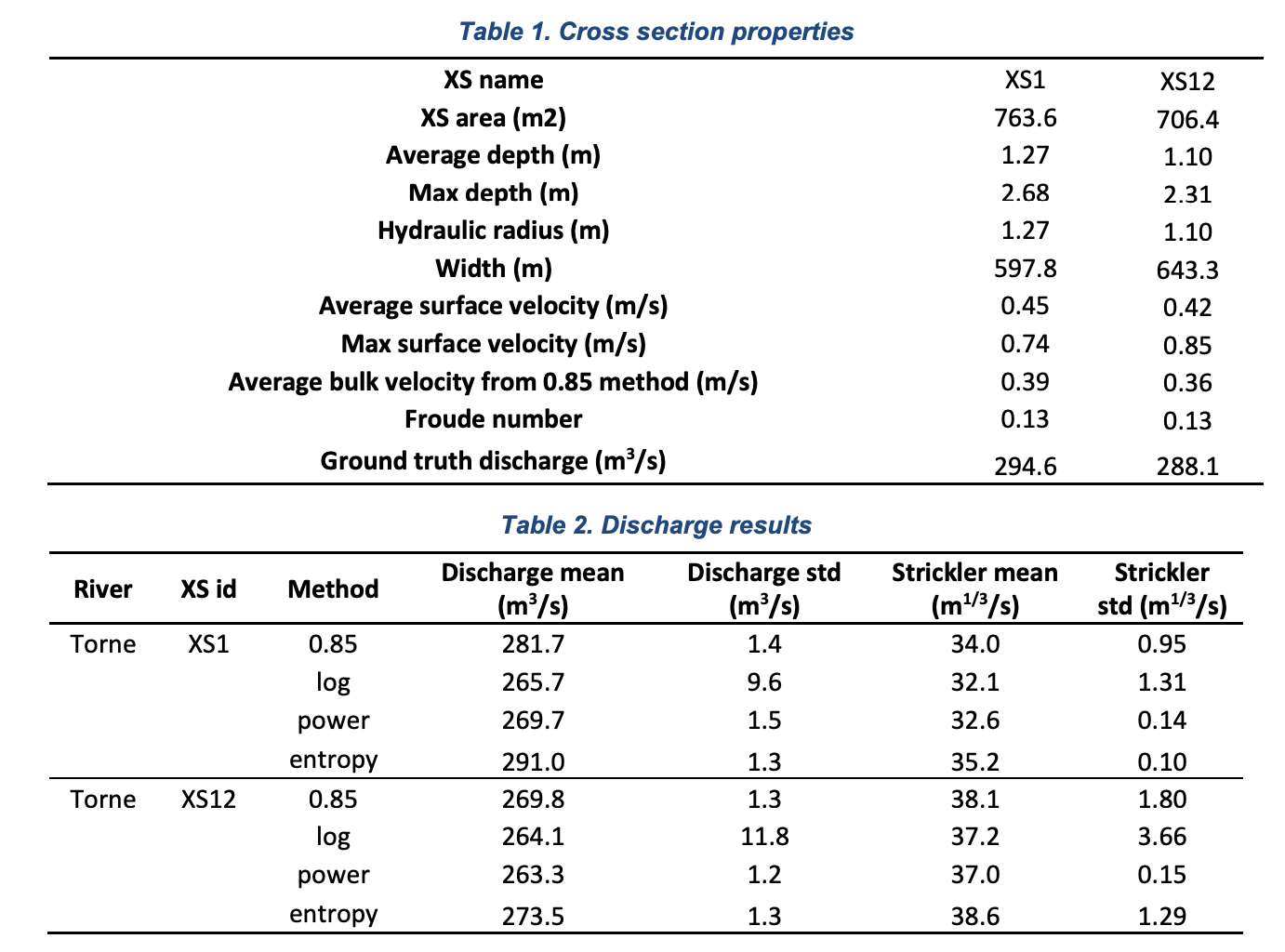
By combining results of the previous SPH hydrometric methods which allow to calculate water surface elevation, riverbed elevation as well as river velocimetry, it is possible to calculate river discharge in cubic meters per second.
Manual measurement involves simultaneous measurement of flow velocity and depth at multiple points throughout the river cross section. 20-25 verticals per river cross section. Alternatively the acoustic doppler current profiling can be used or using tracer dilution. But these methods require contact with water.
During extreme flows and floods it can be impossible, dangerous or very time consuming to measure river cross sections.
Airborne river discharge measurements are expected to be 15% less accurate but they are generally safer and the error decreases on larger rivers.
Water surface elevation, riverbed size and surface velocimetry points.
15%
0.75-1.5 cross sections per hour
Unmanned methods allow to perform contactless river discharge estimation, allowing it to be done even in extreme circumstances such as floods or over rapid flows.
River discharge monitoring is used for water resource management, forecasting and assessing the risk of floods.
CSV table with cross section IDs and discharge estimates.

SPH Engineering is part of the UAWOS consortium which is funded by Horizon Europe. The UAWOS (Unmanned Airborne Water Observing System) project develops airborne and contactless technologies that allow to survey hydrologic events in remote and hard to reach areas and poorly monitored rivers.
Discover the UAWOS project »»»