
Unexploded ordnance (UXO) and abandoned ordnance remain dangerous for decades after conflicts end. Locating and clearing these items is a critical step before any land development, agricultural use, or infrastructure construction can begin. This article covers what UXO is, why drone magnetometer surveys are effective for UXO detection, how the survey workflow operates in practice, and what limitations operators need to account for during mission planning.
The technical detail in this article draws on the expertise of Alexey Dobrovolskiy, CTO of SPH Engineering, and on real-world UXO survey operations using SPH Engineering's integrated drone magnetometry systems.
Key Takeaways
- Drone UXO detection uses UAV-mounted magnetometers to detect buried ferrous ordnance by measuring disturbances in the Earth's magnetic field
- UXO surveys identify unexploded bombs, artillery shells, mortar rounds, rockets, and submunitions
- Drone magnetometer surveys can scan approximately one hectare per hour (or faster with multi-sensor payloads), covering large contaminated areas in days rather than weeks
- Magnetic anomaly analysis helps identify and classify potential UXO targets for follow-up investigation
- No UXO detection method can guarantee 100% detection, but drones allow safe, repeatable data collection over hazardous ground
What Is UXO Detection and Unexploded Ordnance?
UXO refers to munitions (projectiles, bombs, rockets, mortar rounds) that were fired, dropped, or launched during military operations but failed to detonate. They remain live and dangerous underground, sometimes for decades. UXO identification and clearance is a required step before land can be safely used.
Abandoned ordnance is a related but distinct category. It includes explosive items that were stored, stockpiled, or transported but never used, then left behind when forces withdrew. Both categories fall under the broader term ERW (Explosive Remnants of War).
While UXO and abandoned ordnance are often grouped together in clearance operations, this article focuses primarily on UXO detection using drone-mounted magnetometers.
Why UXO Detection Is Critical in Post-Conflict Areas
Modern munitions, despite engineering advances, still have failure rates ranging from 5% to as high as 40% depending on the weapon type, age, and conditions of use. That means a significant percentage of everything fired during a conflict remains unexploded on or under the ground.
"For instance, in Ukraine, where artillery shells are used extensively, up to 20,000 shells per day are deployed, with approximately 1,000 shells remaining unexploded. This poses a long-term threat to the safety of affected areas long after conflicts have ended," said Alexey Dobrovolskiy, CTO of SPH Engineering.
This scale of contamination makes manual UXO survey methods impractical for large areas. A team walking a field with handheld detectors covers a fraction of a hectare per day. A drone UXO survey using magnetometers covers approximately one hectare per hour, scanning the same field in a single flight session. For countries dealing with contamination across thousands of square kilometers, drone-based UXO detection is the only realistic way to survey land at the speed the problem demands.
UXO vs. Landmines: Key Differences in Detection
Landmines and UXO both pose risks after conflicts, but they differ in ways that matter for detection planning.
Landmines are intentionally buried, typically at shallow depth, and designed to be triggered by pressure or proximity. Many modern landmines use plastic casings with minimal ferrous metal content. This makes them very difficult to detect with magnetometers or standard metal detectors.
UXO, by contrast, consists of manufactured munitions (shells, bombs, rockets) that contain significant amounts of ferrous metal in their casings. This ferrous content creates measurable disturbances in the Earth's magnetic field, which makes UXO well suited for detection by drone-mounted magnetometers.
Magnetometer-based drone surveys are effective for UXO detection specifically because of this ferrous metal content. For landmine detection, other technologies such as ground-penetrating radar (GPR) or electromagnetic induction (EMI) sensors are more appropriate. SPH Engineering also supplies drone-integrated GPR systems for applications including landmine and UXO detection research.
Real Use Case: Drone-Based UXO Detection
In early 2023, a drone UXO survey was conducted over a 29.2-hectare farmland field. The area had served as a frontline during World War II, and the land had remained contaminated with unexploded ordnance for decades.

Over the course of a few days, the survey identified and located 158 UXO items. All were subsequently disposed of by clearance teams. The scanning also led to the discovery and safe destruction of a 250-kilogram bomb buried at a depth of 1.8 meters.
The integrated system used in this project included:
- UgCS PRO for flight planning and mission management, including automated survey grid generation and terrain-following altitude control
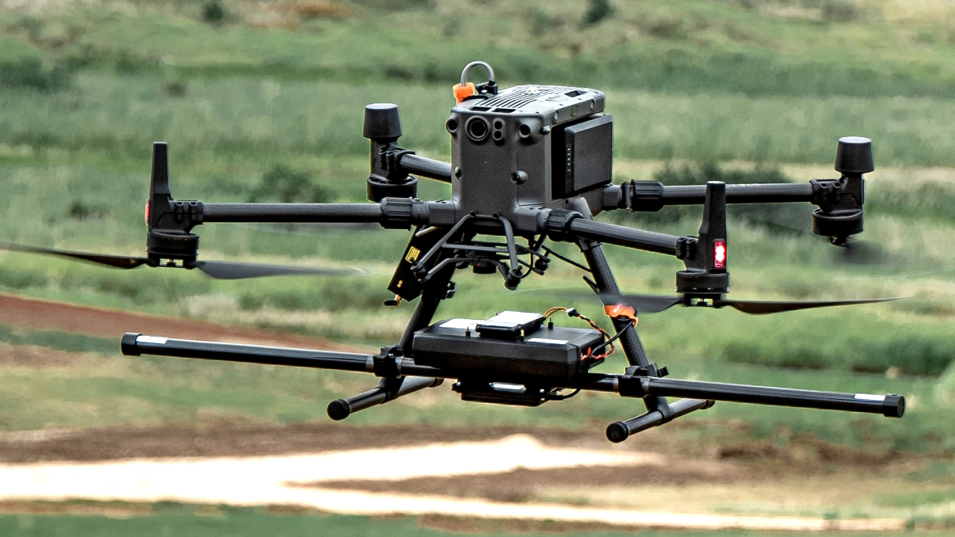
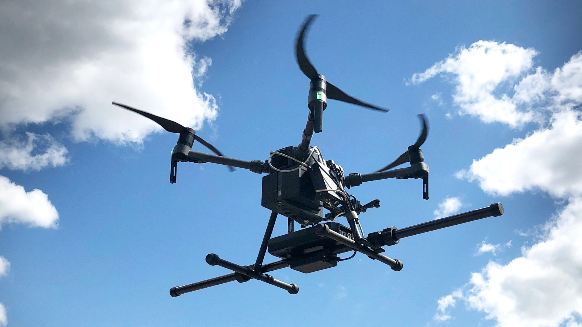
- A multirotor drone equipped with a terrain-following system to maintain consistent sensor height above ground
- SENSYS MagDrone R3 magnetometer (manufactured by SENSYS GmbH, Germany), a scalar magnetometer designed specifically for drone-based magnetic surveys
- SENSYS MAGNETO software for post-flight data processing, filtering, and magnetic anomaly mapping
This combination of UXO detection equipment and software demonstrates how an integrated drone magnetometer survey system works in practice: UgCS plans and controls the flight, SkyHub (SPH Engineering's onboard computer) or the drone's autopilot maintains precise altitude and position, the magnetometer records magnetic field data continuously during flight, and processing software converts raw measurements into anomaly maps that clearance teams can act on.
Why Drone Magnetometer Surveys Improve UXO Detection
Magnetometers detect UXO by measuring disturbances in the Earth's magnetic field. Every ferrous metal object underground creates a local magnetic anomaly, a small deviation from the background field. By flying a magnetometer across a survey area at low altitude in closely spaced parallel lines, drones build a detailed map of these anomalies. Trained analysts then interpret the map to identify targets that are consistent with buried ordnance.
Speed and coverage. Drone magnetometer surveys typically achieve productivity of around one hectare per hour with a single-sensor setup. Multi-sensor magnetometer payloads (carrying two or more magnetometers in parallel) increase coverage rates proportionally. SPH Engineering's systems support various magnetometer configurations depending on the survey requirements and target size.
Safety. The drone flies over the contaminated area while operators remain at a safe standoff distance. No personnel need to walk across ground that may contain live ordnance. This is the primary advantage of drone-based UXO surveys over traditional ground-based methods.
Consistency and repeatability. UgCS flight planning software generates automated survey grids with precise line spacing and terrain following. Every pass is flown at the same altitude and speed, with the same line spacing. This consistency produces uniform data quality across the entire survey area, which is difficult to achieve with manual ground surveys.
Access to difficult terrain. Drones can survey areas that are difficult or impossible to access on foot: flooded fields, steep hillsides, dense scrubland, and coastal zones. The sensor altitude is maintained by the terrain-following system regardless of ground conditions.
How Drone UXO Surveys Work
A drone UXO survey follows a structured workflow from initial assessment through to follow-up investigation. Each stage builds on the previous one.
Non-Intrusive vs. Intrusive UXO Surveys
UXO clearance follows the International Mine Action Standards (IMAS) land release process, which distinguishes between non-intrusive (remote sensing) and intrusive (physical excavation) survey stages.
Drone magnetometer surveys fall into the non-intrusive category. They gather data remotely without disturbing the ground. The survey output is a list of magnetic anomalies with coordinates, not a confirmed identification of each buried item. Follow-up intrusive investigation (physical digging and disposal by qualified EOD teams) is required to confirm and clear identified targets.
Survey Planning and Risk Assessment
Before flying, the survey team defines the area boundaries, assesses the expected ordnance types (which determines the required line spacing and sensor height), and evaluates terrain and environmental conditions.
In UgCS, the operator creates a survey grid over the target area using the Area Scan tool, sets the line spacing based on the expected target size, and configures terrain-following altitude. For UXO detection, recommended line spacing depends on the type of ordnance expected. According to SPH Engineering's guidelines, a 0.5 m line spacing provides detection coverage for small items like hand grenades and submunitions, while 1 m spacing is sufficient for larger items like artillery and mortar shells.
Flight altitude for UXO magnetometer surveys is typically 1-2 m above ground. This requires true terrain following, because magnetic signal strength decreases rapidly with distance from the source.
Data Acquisition Using UAV Magnetometers
During the flight, the magnetometer records magnetic field measurements continuously (typically at sample rates of several hundred hertz) while the drone flies the pre-planned survey grid. UgCS controls the flight path, speed, and altitude. The magnetometer data is geotagged with precise GPS coordinates so each measurement can be mapped to its location on the ground.
Flight speed is determined by safety considerations and terrain. SPH Engineering recommends approximately 2 m/s for typical UXO survey conditions over farm fields and similar terrain, which balances data quality with coverage efficiency.
Magnetic Anomaly Detection and Target Identification
After the flight, the raw magnetometer data is processed using software such as SENSYS MAGNETO or SPH Engineering's GeoHammer. Processing includes data cleaning (removing noise and interference), applying magnetic field corrections, and generating anomaly maps.
Analysts review the anomaly map to identify locations where the magnetic field deviates significantly from the background. Each anomaly is evaluated based on its amplitude, shape, and spatial characteristics. Anomalies consistent with ferrous ordnance are flagged as potential UXO targets and assigned coordinates for follow-up investigation.
UXO Survey Outcomes and Follow-Up Investigation
The survey deliverable is a target list with GPS coordinates and anomaly characteristics for each identified location. This list is handed to qualified EOD (Explosive Ordnance Disposal) teams who conduct intrusive investigation: physically excavating each flagged location, identifying the item, and disposing of confirmed UXO.
The drone survey does not replace the intrusive clearance stage. It replaces the much slower process of ground-based non-intrusive survey, reducing the time needed to identify target locations from weeks or months to days.
Limitations and Operational Considerations in Drone UXO Detection
Like all geophysical UXO detection methods, drone magnetometer surveys have operational limitations that must be considered during mission planning.
Detection Uncertainty
No sensor, whether drone-mounted or ground-based, can guarantee a 100% detection rate for buried ordnance. If the same area is surveyed multiple times with the same sensor and flight pattern, the list of identified targets may vary between runs due to small differences in flight altitude, sensor noise, and environmental conditions.
This means the results of a drone UXO survey should not be interpreted as a guarantee of the presence or absence of ERW. The survey identifies probable target locations. It does not certify an area as clear.
That said, drones with magnetometers are a valuable tool for data gathering during the non-technical survey (NTS) or technical survey (TS) stage of the land release process. They allow large areas to be assessed without putting personnel at risk, and the data they collect supports informed decision-making about where to focus intrusive clearance efforts.
Sensor Height and Magnetic Signal Strength
The amplitude of magnetic anomalies decreases rapidly with distance from the source, following an inverse-cube relationship. A small UXO item at 2 m depth produces a much weaker signal than the same item at 0.5 m depth.
For this reason, effective drone UXO surveys require flying as low as possible, ideally 1 m or less above the ground surface. This demands precise terrain-following capability. SPH Engineering's SkyHub onboard computer provides True Terrain Following using a downward-facing rangefinder, maintaining consistent altitude above the actual ground surface regardless of GPS or barometric altitude errors.
Environmental and Terrain Constraints
Dense vegetation, tall crops, or uneven ground can prevent the drone from maintaining the required low survey altitude. If the drone must fly higher to avoid obstacles, detection sensitivity decreases.
Areas with thick tree cover or tall standing structures may require ground-based survey methods instead of, or in addition to, drone surveys. Coastal zones with soft sand or mudflats are generally well suited to drone magnetometry because the terrain is open and relatively flat.
Weather is also a factor. High winds reduce flight stability and make it harder to maintain precise line spacing at low altitude. Most drone UXO surveys are conducted in calm conditions with wind speeds below 5-8 m/s.
Electromagnetic Interference
Power lines, railroads, buried pipelines, fences, and other metallic infrastructure create magnetic signatures that can mask or be confused with UXO anomalies. Survey areas near known metallic infrastructure require careful planning to avoid false positives.
If electromagnetic interference sources cannot be avoided, they need to be documented and accounted for during data processing. Anomalies near known interference sources are evaluated with extra caution.
Metallic Debris Contamination
Former military sites often contain large quantities of non-hazardous metallic debris (shrapnel fragments, equipment parts, spent casings) in addition to actual UXO. A magnetometer cannot distinguish between a live artillery shell and a piece of scrap metal of similar size. Both produce magnetic anomalies.
In heavily contaminated areas, the anomaly map may contain hundreds or thousands of targets, most of which turn out to be harmless debris. This increases the cost and time required for intrusive investigation. Survey planning should account for expected debris density when estimating clearance timelines and budgets.
Operator Expertise
Effective UXO magnetometer surveys require trained operators at every stage: mission planning in UgCS, flight execution, data processing, and anomaly interpretation. Incorrect line spacing, improper sensor calibration, or inexperienced data analysis can all reduce detection rates or produce unreliable results.
SPH Engineering provides comprehensive training programs covering system installation, calibration, flight operations, data collection, and analysis for its integrated magnetometer survey systems.
Conclusion
Drone UXO detection using magnetometer surveys is an established method for unexploded ordnance surveys in post-conflict zones, former military training areas, and land undergoing development. By flying magnetometers at low altitude over contaminated areas, drone surveys locate buried ferrous ordnance quickly and safely, keeping personnel out of hazardous zones while covering ground at rates that manual methods cannot match.
The integrated system approach (UgCS for flight planning, a terrain-following drone platform, a purpose-built magnetometer payload, and dedicated processing software) ensures that each component of the survey workflow is optimized for the task. The Case Study demonstrates what this looks like in practice: 29.2 hectares surveyed, 158 UXO items located and cleared, including a 250 kg bomb at 1.8 m depth.
UXO detection is inherently uncertain. No sensor guarantees 100% detection. But drone magnetometer surveys provide the best available combination of speed, safety, coverage, and data quality for the non-intrusive survey stage of the land release process. Combined with qualified EOD follow-up, they are helping make contaminated land safe for use again.