

Mining companies deploy drones to cut survey times from weeks to hours, reduce operational costs by up to 70%, and eliminate risks to personnel. From prospecting and exploration to daily operations and environmental monitoring, drones collect accurate data faster and safer than ground crews, helicopters, or rope access teams.
Mining operations face a simple problem: how do you map dangerous terrain, measure stockpiles, and inspect pit walls without putting people at risk or spending weeks on surveys?
Drones solve this. They fly into areas where ground crews can't safely go. They survey in hours what used to take weeks. And they cost a fraction of what helicopters or rope access teams charge.
Here's where drones make the biggest difference in mining and what technology helps you get results.
How are Drones Used in Mining
Speed matters in mining. A drone surveys 10 square kilometers in a few hours. Ground teams need weeks for the same area. BHP, one of the world's largest mining companies, processes their surveys in under 30 minutes now. They used to rely on terrestrial laser scanning, which took days and cost more.
The math works out clearly. Companies report 70% lower costs using drones instead of helicopters. You save money on equipment, personnel, and time.
Safety drives many of these decisions. Steep pit walls can collapse. Toxic ponds leak. Active blast zones are unpredictable. Drones go into these areas so people don't have to.
Data quality improved, too. High-resolution cameras capture millimeter-level detail. You see cracks in walls before they become failures. You measure stockpiles accurately enough to optimize blending. You map terrain precisely enough to plan haul roads.
Prospecting and Early Surveys
Early-stage prospecting identifies underground hazards and maps site conditions before crews arrive. Drones equipped with magnetometers scan large areas to detect buried objects, abandoned infrastructure, and geological features that affect project planning.
Before you dig, you need to know what's underground and what hazards exist on site.
Magnetometer-equipped drones find metal objects buried underground. They detect abandoned infrastructure, unexploded ordnance, and historical mines that weren't properly documented. This happens before your crews arrive on site.
Nevada University used drones for geothermal exploration. They scanned areas 4-10 times larger than ground surveying allowed. The magnetometry helped them map fluid pathways for blind geothermal systems.
Drones deliver clear advantages for prospecting work:
- Faster coverage: Survey 4-10 times more area compared to ground-based methods in the same timeframe
- Safety first: Identify unexploded ordnance and hazardous areas before personnel enter the site
- Lower costs: Eliminate expensive helicopter surveys and reduce crew hours in the field
- Better detection: Magnetometers find buried metal objects, abandoned mines, and underground infrastructure that visual surveys miss
- Accurate mapping: Create detailed site maps with precise coordinates for hazards and features
- Immediate data: Process results quickly to guide permitting and planning decisions
- Remote access: Survey difficult terrain without building access roads or clearing vegetation
You can survey faster and cover more ground. The data guides your next steps.
Drone Mapping for Geological and Resource Exploration
Resource exploration requires detailed geological mapping to locate ore deposits and assess mineral potential. Drones equipped with specialized sensors map magnetic fields, terrain features, and subsurface structures across vast areas before committing to expensive drilling programs.
Finding ore deposits requires detailed geological mapping. Drones with magnetometers identify variations in magnetic fields that signal ore bodies. LiDAR builds precise elevation models. High-resolution cameras reveal rock formations and geological anomalies.
Helicopters used to do this work. Drones do it cheaper and fly lower for better detail. Unlike helicopter surveys, drones collect higher-resolution data at lower altitudes with greater flexibility.
Magnetometers detect variations in Earth's magnetic field caused by different rock types and mineral concentrations. Iron ore, nickel, and other magnetic minerals create distinct signatures. Drones fly systematic grid patterns, collecting magnetic data across entire survey areas that help identify potential ore bodies.
Ground-penetrating radar (GPR) sends electromagnetic pulses into the ground to map subsurface structures. It reveals layers of different rock types, voids, and geological discontinuities. GPR identifies stratigraphic horizons and structural features that indicate mineralization beneath the surface.
LiDAR sensors use laser pulses to create accurate 3D terrain models. They penetrate vegetation to expose geological structures that cameras miss. LiDAR shows fault lines, rock outcrops, and terrain patterns that indicate different geological formations with centimeter-level accuracy.
High-resolution cameras capture detailed images of exposed rock surfaces, revealing color variations and weathering patterns. Multispectral cameras capture wavelengths that highlight mineral content invisible to the human eye. Photogrammetry software processes images into 3D models and orthomosaic maps.
Drones transform how exploration teams work:
- Cost reduction: 70% lower costs compared to helicopter-based surveys
- Higher resolution: Fly lower for better detail and more precise measurements
- Larger coverage: Survey 4-10 times more area than ground-based methods
- Flexible deployment: Revisit sites quickly as exploration priorities change
- Multi-sensor capability: Combine magnetometry, GPR, LiDAR, and imaging in single operations
- Safer access: Map remote or hazardous terrain without ground crews
Daily Site Mapping for Active Mine Sites
Active mining operations require up-to-date site information as conditions change from blasting, excavation, and equipment movement. Daily drone surveys capture current site status, track progress, and identify issues before they impact operations.
Operations need current information. Sites change daily from blasting, excavation, and equipment movement.
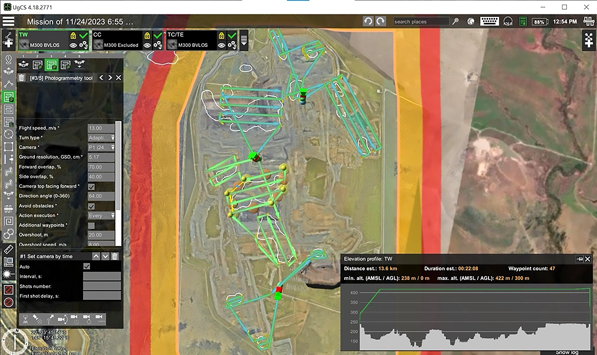
Drones capture overlapping photos that software stitches into 3D models and orthomosaic maps. Flight planning software like UgCS keeps the drone at consistent altitude over uneven ground. This maintains uniform image quality across the entire survey.
BHP surveys up to 10 square kilometers in single flights. They upload fresh elevation models every night because the terrain changes that fast. Their pilots work in areas with no cell service, so everything runs offline.
The workflow looks like this: plan the mission on desktop, transfer to tablet, fly the site, process the data. Results in under an hour for stockpile surveys.
Daily drone mapping delivers measurable operational improvements:
- Rapid turnaround: Complete surveys and deliver processed results in under one hour
- Current data: Track daily changes from blasting, excavation, and material movement
- Offline operation: Work in remote mine sites without cellular or internet connectivity
- Large area coverage: Survey up to 10 square kilometers in single flights
- Consistent quality: Terrain-following maintains uniform image resolution across uneven ground
- Progress tracking: Compare daily models to monitor excavation rates and identify delays
- Better planning: Provide production teams with accurate site conditions for next-day operations
Mining companies can also centralize and automate their site monitoring workflows. Learn more about remote monitoring of mining sites with DroneGIS.
Stockpile Volume Measurements
Accurate stockpile inventory directly impacts production planning, blending operations, and financial reporting. Drones measure stockpile volumes with precision that manual methods and visual estimates can't match, delivering reliable tonnage calculations for materials management.
You need accurate inventory numbers for planning and profit calculation. Visual estimates don't cut it.
Drones survey stockpiles in a single battery flight. Photogrammetry software calculates tonnage from the images. BHP measures areas of 1.2 km by 1 km weekly. They deliver reports from takeoff to final numbers in under one hour.
Accurate stockpile data helps optimize coal blending and material mixing. You know exactly what you have and where it sits.
Drone-based stockpile measurement transforms inventory management:
- Fast results: Complete surveys and generate volume reports in under one hour
- High accuracy: Photogrammetry delivers precise tonnage calculations for financial reporting
- Weekly monitoring: Track inventory changes and material consumption rates consistently
- Blending optimization: Know exact volumes and locations for coal blending and material mixing
- Single-flight coverage: Survey large stockpile areas (1.2km x 1km) without battery changes
- Cost savings: Eliminate manual surveying labor and reduce equipment downtime
- Historical tracking: Compare volumes over time to identify discrepancies and improve accounting
High Wall Inspections
Open-pit high walls pose constant collapse risks that threaten personnel and equipment. Regular drone inspections detect structural changes, cracks, and instability before failures occur, preventing accidents and costly downtime.
With open-pit walls, there always exists a risk of collapse without warning. Regular monitoring catches problems early.
Manual inspections require rope access teams who climb down the walls with harnesses. This takes days and puts people at risk. Terrestrial laser scanners are safer but still slow.
An automated vertical scan tool automates the whole process. You define the scan area, set the altitude and overlap, and let it fly. The drone maintains a consistent distance from the wall and captures images with proper overlap. Software builds millimeter-resolution 3D models.
Run the same scan monthly. Compare the models. Spot structural changes before they collapse.
Companies using UgCS cut inspection time from days to hours. Some report saving 4-5 days per wall, depending on size.
Automated drone inspections deliver clear safety and efficiency gains:
- Eliminate personnel risk: No rope access teams climbing dangerous walls with harnesses
- Time savings: Reduce inspection time from days to hours (4-5 days saved per wall)
- Millimeter precision: Capture structural details that reveal early-stage cracking and instability
- Repeatable missions: Run identical scans monthly to track changes over time
- Consistent data quality: Maintain uniform distance and overlap for accurate comparisons
- Faster decisions: Identify problem areas quickly and prioritize remediation work
- Complete coverage: Automated patterns ensure no sections are missed during inspections
Pre and Post-Blast Monitoring
Blast operations require detailed documentation before and after detonation to assess effectiveness, measure material movement, and verify safety conditions. Drones capture comprehensive site data without exposing personnel to unstable blast zones.
You need to know what the blast accomplished before planning the next steps.
Pre-blast surveys establish baseline conditions. Post-blast surveys measure fragmentation and material movement. Safety checks confirm the area is stable before crews enter.
Drones capture all this from safe distances. No one goes into potentially unstable zones.
Drone-based blast monitoring improves safety and planning:
- Personnel safety: Survey blast zones from safe distances without entering unstable areas
- Baseline documentation: Capture precise pre-blast conditions for accurate comparison
- Fragmentation analysis: Measure rock size distribution to optimize blasting parameters
- Volume calculations: Quantify material movement and assess blast effectiveness
- Fast deployment: Survey immediately after blast while conditions are fresh
- Better planning: Use accurate post-blast data to plan excavation and loading operations
- Cost optimization: Identify underperforming blasts and adjust parameters to reduce drilling and loading costs
Haul Road Condition Assessment
Mine haul roads deteriorate rapidly under constant heavy equipment traffic. Regular drone surveys identify damage, erosion, and maintenance needs before they escalate into costly repairs or equipment failures.
Heavy equipment tears up roads fast. Damaged roads waste fuel and break equipment.
Corridor mapping software plans and automates long, narrow flight paths along roads. You spot damage, erosion, and maintenance needs. Fix problems before they get expensive.
Better roads mean lower fuel costs and less equipment downtime.
Drone corridor surveys optimize road maintenance programs:
- Proactive maintenance: Identify damage early before it causes equipment failures or accidents
- Fuel savings: Well-maintained roads reduce fuel consumption across entire haul truck fleets
- Reduced downtime: Prevent unexpected equipment damage that halts operations
- Complete coverage: Automated corridor scans ensure no road sections are missed
- Regular monitoring: Weekly or monthly surveys track deterioration rates and maintenance effectiveness
- Prioritized repairs: Visual data helps allocate maintenance resources to highest-priority sections
- Cost tracking: Document road conditions over time to justify maintenance budgets and improve planning
Tailings Dam Safety
Tailings storage facility failures cause environmental catastrophes, loss of life, and massive financial liability. Continuous drone monitoring detects structural instability, moisture infiltration, and leaks before they develop into failures.
Tailings storage facilities hold mining waste. When they fail, the results are catastrophic. Regular monitoring prevents disasters.
Drones detect structural changes through repeated surveys. Ground-penetrating radar finds dangerous moisture levels inside the dam. Thermal imaging and GPR spot leaks early.
A Chilean mining company flies their tailings dam monthly with drones and RadarTeam SE70 GPR. They track humidity levels against the dam wall. They compare stability data within the production front. Problems get caught before they become emergencies.
Drone-based tailings dam monitoring provides critical safety oversight:
- Early warning: Detect structural changes and moisture infiltration before failure occurs
- Subsurface insight: GPR reveals dangerous humidity levels inside dam walls that visual surveys miss
- Leak detection: Thermal imaging and GPR identify seepage and weak points early
- Monthly tracking: Regular surveys establish trends and catch gradual deterioration
- Stability comparison: Compare data over time to assess dam wall integrity and production front conditions
- Compliance documentation: Provide regulators with detailed monitoring records and safety data
- Risk mitigation: Prevent catastrophic failures that cause environmental damage, loss of life, and regulatory penalties
Environmental Monitoring
Mining operations face strict environmental regulations during active production and through site closure. Drones collect environmental data safely and efficiently, supporting compliance reporting and demonstrating responsible stewardship.
Regulations require mines to track environmental impact during operations and after closure.
Drone-mounted water samplers collect samples from toxic ponds. No one enters contaminated areas. Multispectral cameras measure vegetation health during reclamation. Echo sounders map water depth and sediment in flooded pits.
The data support compliance reporting and site closure planning.
Drone-based environmental monitoring streamlines compliance and safety:
- Personnel protection: Collect water samples from toxic ponds without exposing workers to hazardous conditions
- Vegetation tracking: Multispectral imaging measures plant health and reclamation progress objectively
- Bathymetric surveys: Map water depth and sediment accumulation in flooded areas and retention ponds
- Regular compliance: Conduct frequent monitoring to meet regulatory reporting requirements
- Closure documentation: Provide detailed baseline and progress data for site closure approvals
- Cost efficiency: Reduce environmental monitoring costs compared to ground-based sampling methods
- Historical records: Build comprehensive datasets that demonstrate environmental responsibility over time
Successful Examples of Drones in Mining
DATUM Ingeniería SAS: Drone-based GPR and Echo Sounder for Mining Operations Enhancement

El Cerrejón, one of the world's largest coal mines in Colombia, faced two critical safety challenges: detecting underground coal pockets that could collapse under heavy equipment and measuring sediment buildup in water reservoirs after heavy rainfall.
SPH Engineering and DATUM Ingeniería deployed drone-based Ground Penetrating Radar (GPR) with a 100 MHz antenna to scan areas where heavy machinery operates. The surveys successfully identified subsurface burning coal bags before excavation began, allowing the mine to address hazards proactively and prevent equipment damage or personnel injuries.
For water management, a dual-frequency echo sounder mounted on a DJI M300 surveyed the mine's water reservoir. The system measured both water depth and sediment layer thickness, providing data essential for maintenance protocols and flood preparation.
The combination of UgCS flight planning and DroneGIS data management enabled efficient survey execution and team collaboration. El Cerrejón now addresses subsurface hazards before they become emergencies and maintains accurate water management data for operational planning.
BHP: UgCS Empowers Mining Potential. A Case Study of BHP's Drone Deployment
BHP, a world-leading resources company operating in over 90 locations worldwide, transformed their mining surveys by switching from terrestrial laser scanning to drones. The challenge was conducting daily surveys across rapidly changing terrain with near-vertical walls in remote areas with no cellular connectivity.
Using DJI M300 and M200/210 drones with DJI P1 cameras, BHP now surveys up to 10 square kilometers in single flights. They process nadir surveys in under 30 minutes and deliver complete stockpile volume reports from flight to final numbers in under one hour. Multiple pilots operate drones simultaneously at each mine site using altitude separation for deconfliction.
The operation runs entirely offline. Custom GEOTIFF elevation models and TIFF background images are uploaded to tablets nightly to account for terrain changes. Data is captured on SD cards and processed using in-house machine learning techniques.
BHP cut costs significantly compared to terrestrial laser scanning while improving speed, safety, and data completeness. The processed data feeds directly into live 3D mine programs, enabling extraction of critical safety information and assisting production teams with planning.
"As RPA operations become more complex, we require solutions that display the right information at the right time. UgCS provides us the tools to manage air and ground risks whilst operating a variety of different RPA," says Luke Burton, Chief Remote Pilot at BHP.
Future-Proofing Mining: Preventing Tailings Storage Facility Leaks with Advanced Humidity Monitoring and Airborne GPR Technology

Tailings storage facilities pose catastrophic risks when they fail. Past disasters like Brumadinho (270 deaths) and Samarco (19 deaths) in Brazil highlight the critical need for continuous monitoring. A Chilean mining company needed to detect dangerous humidity levels inside tailings dam walls before they led to liquefaction and collapse.
The company deployed a DJI M600Pro equipped with RadarTeam SE70 ground-penetrating radar and UgCS with True Terrain Following. The system conducted monthly humidity analysis across the tailings dam wall, providing high-resolution subsurface images that identified moisture-related anomalies invisible to visual inspection.
GPR surveys revealed humidity buildup that indicated potential instability. The non-invasive method covered large areas quickly without disturbing the dam structure. Real-time monitoring during the two-week project enabled the team to track humidity levels and compare monthly data to detect changes.
The mining company now catches potential failures before they develop into emergencies. Monthly assessments provide early warning of risks, allowing proactive intervention. The airborne approach proved more efficient, cost-effective, and safer than traditional methods like drilling or piezometers.
By monitoring humidity levels continuously, the operation maintains stability and protects surrounding communities from environmental disaster.
DAMS: Remote monitoring of Mining Sites with DroneGIS
Choosing the Right Drone Mapping Software for Mining Operations
Mining operations require more from their drone software than basic consumer apps provide. You need tools that handle complex terrain, work without internet connectivity, and manage multiple sensors across different drone platforms.
Professional drone mapping software separates successful mining programs from frustrating ones. The right platform determines whether your drone program delivers reliable data or wastes time with re-flights and processing errors.
Key Features to Look For
Desktop planning capability matters for complex missions. Mining surveys cover large areas with challenging terrain. You need full-screen workspace to import boundaries, visualize elevation profiles, and spot obstacles before flying.
Offline operation is non-negotiable. Mine sites rarely have cellular service. Your software must store maps and elevation data locally.
Terrain following keeps drones at consistent altitude over rapidly changing ground. Look for multiple altitude algorithms that adapt to steep slopes and vertical walls. Custom elevation model import ensures accuracy as site conditions change daily.
Automated mission tools reduce pilot workload and improve data quality. Vertical scanning for pit walls, corridor planning for roads, and photogrammetry patterns should all generate flight paths automatically.
Multi-drone coordination becomes critical as programs scale. Software should help manage altitude separation when multiple drones operate simultaneously.
Hardware flexibility protects your investment. Support for diverse drone platforms and custom payload integration lets you choose the best equipment for each job.
UgCS for Mining Operations
UgCS is professional-grade mission planning software built for complex operations like mining. Companies like BHP use it to process surveys in under 30 minutes and coordinate multiple daily flights.
Key features for mining applications:
- Custom DEM import: Upload elevation models of unlimited size for accurate terrain following
- Offline operation: Plan and fly without internet in remote locations
- Automated vertical scanning: Handle pit wall inspections with preset parameters
- Corridor mapping: Plan linear surveys with battery swap support
- Multi-platform support: Works with DJI, Ardupilot, Autel, Acecore, Freefly, and more
- Sensor integration: Connects with LiDAR, magnetometers, GPR through SkyHub
- 3D mission planning: Visualize elevation profiles before flying
Learn more about UgCS flight planning software.
Advanced Sensors and Payloads for Mining with Drones
Standard RGB cameras handle many mining tasks, but specialized sensors unlock capabilities that visual imaging can't match. These advanced payloads detect subsurface features, measure material properties, and collect samples from hazardous areas without putting personnel at risk.
Magnetometers: detect variations in Earth's magnetic field caused by buried metal objects, ore bodies, and geological features. They locate abandoned mines, unexploded ordnance, and underground infrastructure before excavation begins. In stockpile applications, magnetometers identify tramp metal that would destroy crushers.
Ground Penetrating Radar (GPR): sends electromagnetic pulses into the ground to map subsurface structures, moisture content, and geological layers. GPR identifies dangerous humidity levels inside tailings dam walls that visual surveys miss.
Echo sounders: map water depth and sediment levels in flooded pits, retention ponds, and tailings facilities. Mining service companies use drone-mounted echo sounders to gather depth profiles while keeping personnel away from contaminated water.
Water samplers: collect liquid samples from toxic ponds without exposing workers to hazardous conditions. Drone-mounted systems lower collection bottles into target areas, capture samples, and return them for laboratory analysis.
Thermal & multispectral: detect temperature variations and measure light reflection across multiple wavelengths. Thermal imaging spots leaks in tailings dams and identifies hot spots in stockpiles. Multispectral sensors measure vegetation health during reclamation, tracking plant stress and growth patterns.
Advanced sensor integration platforms:
Professional sensor integration requires hardware that manages power, logging, and real-time data communication. SkyHub by SPH Engineering connects specialized sensors like magnetometers, GPR, echo sounders, and water samplers to drones and flight planning software.
For advanced users, UgCS allows planning geophysical low-altitude surveys for different sensors using SkyHub and an altimeter for real-time terrain awareness. This combination enables consistent sensor height over changing terrain, critical for accurate geophysical data collection.
Challenges and Best Practices in Mining with Drones
Mining environments present unique obstacles that can derail drone programs. Understanding these challenges and applying proven solutions keeps operations running smoothly.
Rapidly Changing Terrain
Mine sites transform daily from blasting and excavation. Elevation maps become outdated quickly, causing terrain-following errors and crashes.
Best practice: Update digital elevation models daily or weekly. BHP uploads custom elevation models to tablets every night to account for rapid site changes.
No Cellular Connectivity
Most mine sites operate without cell service. Cloud-based drone apps become useless.
Best practice: Use flight planning software that runs fully offline. Store maps, elevation models, and mission plans locally on tablets or laptops.
Extreme Weather Conditions
Wind, dust, heat, and high altitudes affect drone performance and reduce battery life.
Best practice: Check weather before flying. Establish maximum wind speed limits. Schedule flights during optimal conditions. Account for reduced battery performance at altitude.
Multiple Drones Operating Simultaneously
Large sites need several drones in the air at once, risking collisions.
Best practice: Establish altitude separation protocols. Assign different vertical zones to each drone. Maintain clear communication between pilots.
Obstacles and No-Fly Zones
Radio towers, cranes, power lines, and active equipment create hazards.
Best practice: Map all obstacles before mission planning. Use software that allows custom hazard marking. Build buffer zones around obstacles.
Data Processing Bottlenecks
Large surveys generate hundreds of gigabytes. Processing takes hours or days, delaying decisions.
Best practice: Invest in adequate processing hardware. Process priority areas first. Use photogrammetry software optimized for mining.
Inconsistent Image Quality
Variable altitude and lighting produce unusable data requiring re-flights.
Best practice: Use terrain-following to maintain consistent ground sampling distance. Fly during optimal lighting. Lock camera settings for entire missions.
Sensor Calibration
Specialized sensors like magnetometers and GPR require proper calibration for accurate results.
Best practice: Follow manufacturer calibration procedures before each mission. Use proven integration platforms like SkyHub. Test systems before field deployment.
Pilot Training
Multiple pilots create inconsistent data quality and inefficiencies.
Best practice: Establish standard operating procedures. Train pilots on automated mission execution. Use the same flight planning software across all teams.
Getting Started with Drones in Mining
Pick one high-value application. Which task costs the most time or money? Start there.
Match your drone and sensor to the job. Test flights in less critical areas first. Train your team properly on both flying and software. Connect drone data to your existing planning and processing software.
Scale up as you gain experience. Add more drones, more sensors, more applications.
The technology works. Companies prove it every day. Traditional methods cost more and take longer. Download UgCS and test it on your specific challenges.
Drones in Mining: FAQs
What are drones used for in mining?
Drones handle surveying, mapping, inspections, and environmental monitoring across all mining stages. They measure stockpile volumes, inspect pit walls, map active sites, explore for minerals using magnetometers, monitor tailings dams with GPR, assess haul roads, and document blast results. Companies use them for tasks that are dangerous, time-consuming, or expensive with traditional methods.
How do drones improve safety in mining operations?
Drones eliminate the need to send personnel into dangerous areas. They inspect steep pit walls without rope access teams, survey blast zones from safe distances, collect water samples from toxic ponds, and monitor unstable tailings dams. Workers stay away from collapse risks, active equipment, and hazardous materials while drones gather the required data.
How accurate are drone surveys for mining applications?
Drone surveys deliver centimeter-level accuracy with proper equipment and techniques. Photogrammetry captures millimeter-resolution details for crack detection. LiDAR provides centimeter-accurate elevation models. Survey-grade positioning with RTK or PPK corrections ensures precise georeferencing. Accuracy depends on flight altitude, camera quality, ground control points, and processing methods.
Are there regulations for flying drones in mining areas?
Yes. Aviation regulations vary by country but generally require pilot certification, operational approvals, and compliance with airspace restrictions. Many mining operations require beyond visual line of sight (BVLOS) waivers. Some countries mandate specific approvals for commercial operations. Work with local aviation authorities to obtain necessary permits before starting drone programs.
What types of sensors are used on mining drones?
Mining drones carry RGB cameras for photogrammetry, LiDAR for terrain modeling, magnetometers for mineral exploration and metal detection, ground-penetrating radar for subsurface mapping, thermal cameras for leak detection, multispectral sensors for vegetation monitoring, echo sounders for bathymetry, and water samplers for environmental testing. Sensor choice depends on the specific application.
What software is used for mining with drones?
Mining operations use specialized flight planning software like UgCS for mission design and execution. These platforms handle terrain following, automated scanning, and offline operation. Photogrammetry software processes images into 3D models and orthomosaics. Data management platforms like DroneGIS centralize storage and analysis. Professional mining programs require desktop planning tools that support custom elevation models and multi-drone coordination.