About Tianjin Zhihui Ocean Technology: Marine Surveying and Hydrological Solutions Provider
Tianjin Zhihui Ocean Technology Co., Ltd., founded in 2018 and headquartered in Tianjin Shi, China, is a rapidly growing high-tech enterprise specializing in oceanographic research and hydrographic services. The company integrates production, sales, and technical support, and is officially certified to perform professional marine surveying and mapping, as well as labor dispatch operations.
Collaborating with well-known domestic and international organizations, Tianjin Zhihui provides professional solutions for the marine, hydrology, and water conservancy industries. Guided by the philosophy of “continuous exploration and improvement,” the company prioritizes user needs, technological advancement, and a long-term contribution to China’s marine innovation.
Field Validation: UAV-Based GPR Bathymetry Across 21 Cities
Tianjin Zhihui Ocean Technology carried out an extensive UAV-based GPR testing program using SPH Engineering’s drone-based GPR integrated system. The project covered 21 cities across eight provinces, representing a diverse range of hydrographic and environmental conditions.
The goal was to evaluate how a drone-mounted radar could overcome the limitations of traditional sonar-based bathymetry. Tests were performed under variable:
- Water surface states, including aquatic vegetation, ice cover, and open water
- Riverbed substrates, such as concrete, sandy, pebble, and silt beds
- Flow velocities and sediment concentrations
- Water conductivity, ranging from 50 μS/cm to over 1000 μS/cm
Part of the radar data was cross-validated with an echosounder measurement to benchmark performance. Five representative cases demonstrated how the combination of Zond Aero LF and UgCS terrain-following mode and the SkyHub drone onboard computer enabled precise, non-contact depth measurements even in the most challenging conditions.
Ice-Covered Surface
Amid changing ice thickness and drifting floes, the 75 MHz Zond Aero LF radar flew at 1 meter altitude and 0.5 m/s. Despite surface freezing, the radar successfully captured clear bed contours, revealing an average depth of 1.2 meters with water conductivity of 410 μS/cm. This confirmed the feasibility of conducting winter hydrological mapping without risking personnel or equipment on unstable ice surfaces.

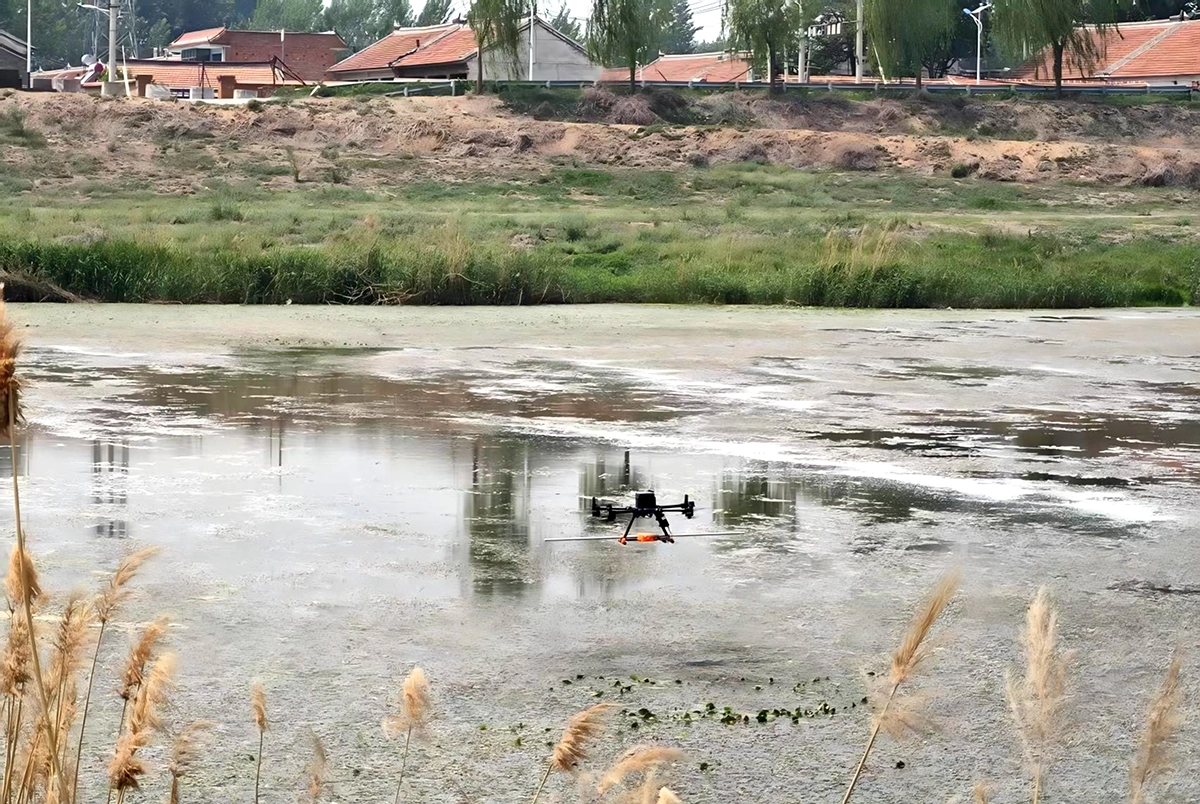
Surface with Aquatic Vegetation
In vegetation-covered channels, traditional sonar often fails due to surface clutter. Using the same configuration, the radar penetrated dense floating vegetation, recording clear subaqueous reflections. The measured depth averaged 1.2 meters with 598 μS/cm conductivity, proving effective even in conditions of heavy biological interference.
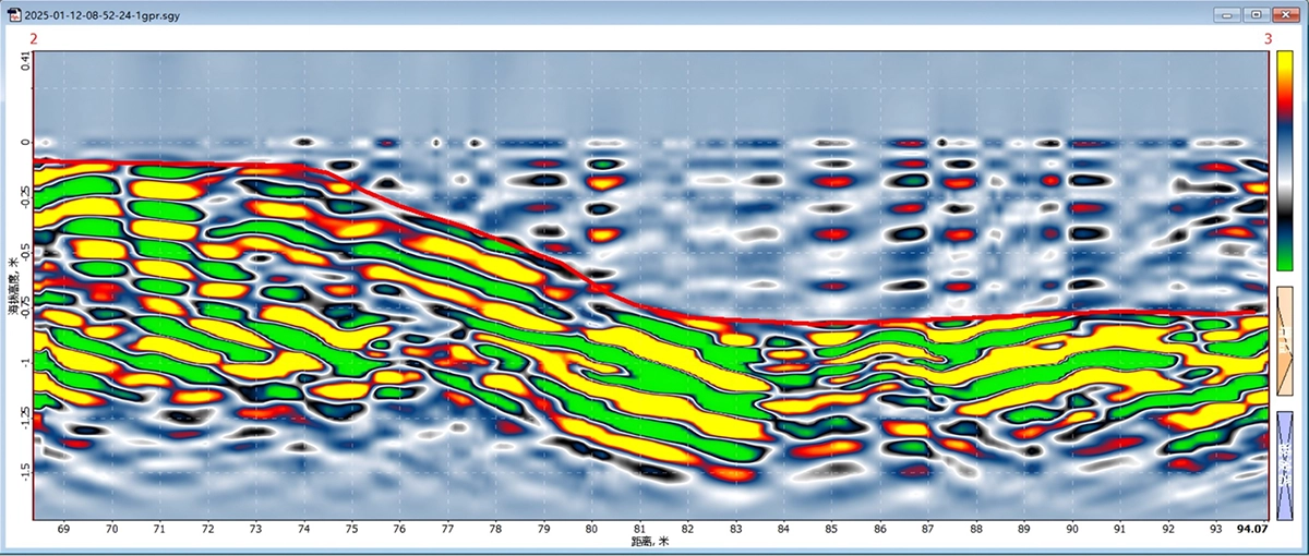
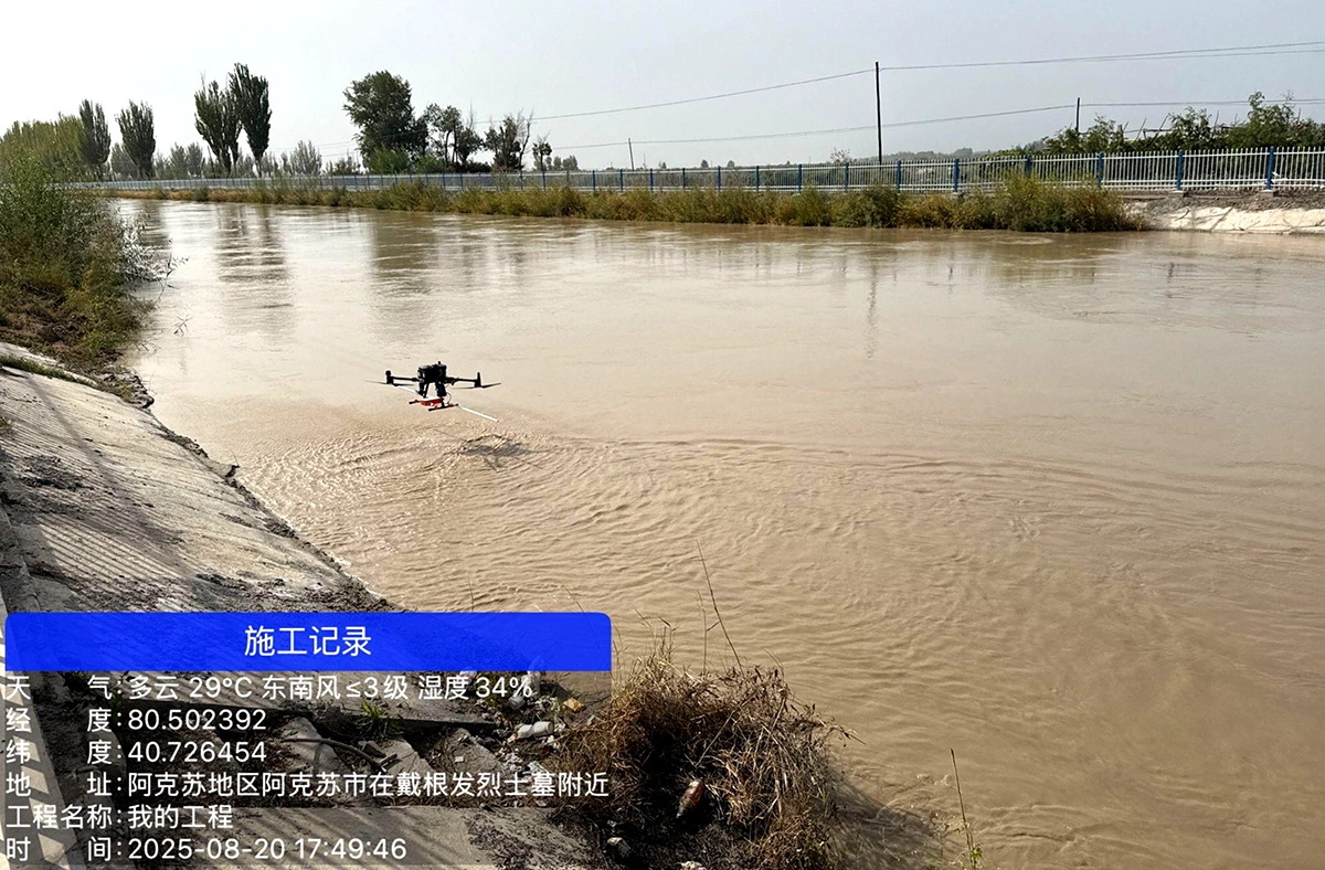
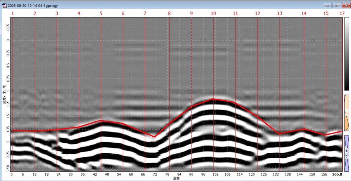
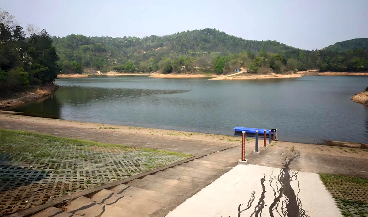
Standard Cross-Section Measurement
An open irrigation channel, approximately 50 meters wide, served as a test for structured environments. The 100 MHz radar, operated at 0.5 m altitude and 0.5 m/s, provided high-definition profiles showing both water depth (1.8 meters) and silt accumulation (up to 0.8 meters). The water conductivity was 536 μS/cm.
This scenario highlighted the technology’s reliability for standard hydrological cross-sections and infrastructure inspections.
Flood Season Depth Survey
During flood events, rapid, safe data acquisition becomes essential. The 75 MHz radar integrated with UgCS terrain-following at 0.7 m altitude and 1 m/s successfully mapped depths up to 5.4 meters. Conductivity levels dropped to 349 μS/cm, compared with 674 μS/cm during dry conditions, showing how environmental changes affect radar signal propagation.
UgCS maintained flight stability despite turbulence and water surface irregularities, enabling uninterrupted data collection during extreme weather.

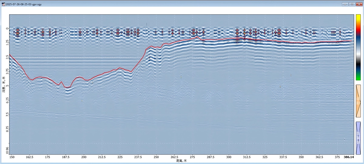
Large-Depth Measurement
In a reservoir, Tianjin Zhihui achieved a breakthrough by measuring depths of up to 13 meters, far exceeding the usual 5-meter limit for GPR-based bathymetry. The 75 MHz radar, flown at 1 m altitude and 1 m/s, produced distinct riverbed reflections even in low-conductivity water (50 μS/cm).
This milestone demonstrated how UAV-mounted radar can extend its operational envelope through optimized frequency, altitude, and flight control parameters.
Accuracy Verification: Cross-Referencing with Echosounder
To ensure result credibility, the radar data was validated against readings collected by Tianjin Zhihui’s A12 unmanned surface vessel equipped with an H200 echosounder. The comparison showed:
- 58% of radar readings deviated by less than 0.1 meters
- 83% were within 0.2 meters of the reference data
- Both systems recorded an identical maximum depth of 3.52 meters
Although this accuracy does not yet meet IHO S-44 Special Order standards, it is sufficiently reliable for environmental, research, and engineering applications that require rapid deployment and safe, remote data collection.

Conclusions: A New Era for Non-Contact Bathymetry
The integration of Zond Aero LF radar with UgCS terrain-following mode represents a major advancement in non-contact bathymetry. By combining stable flight control with high-penetration radar sensing, Tianjin Zhihui Ocean Technology expanded the range of feasible UAV-based hydrological surveys across multiple environments.
Expanding the Boundaries of Application
The tests demonstrated that UAV-mounted GPR can successfully operate in:
- Ice-covered and frozen waterways
- Vegetation-dense channels and wetlands
- Flood-prone and rapidly changing water systems
- Reservoirs and deep inland basins
Such adaptability opens new possibilities for hydrological modeling, flood monitoring, and environmental mapping in conditions where conventional sonar systems are unsafe or inefficient.
Technical Advantages of UgCS
UgCS provided essential control features ensuring stable aircraft attitude, precise altitude tracking, and automated route planning. With RTK-GNSS synchronization, radar data was georeferenced with centimeter-level accuracy, minimizing distortions caused by flight dynamics or GPS drift.
Challenges and Observations
Despite promising results, several technical constraints remain:
- Electromagnetic interference (EMI) near bridges, power lines, and reinforced embankments caused signal aliasing and false echoes.
- Accuracy at greater depths declined beyond 8 meters, indicating a need for refined modeling and improved dielectric calibration.
Nevertheless, the consistency of results across multiple provinces proved the system’s reliability and robustness in real-world fieldwork.
Summary
Through a coordinated campaign across 21 cities, Tianjin Zhihui Ocean Technology demonstrated that UAV-based GPR, when paired with UgCS flight automation, can collect meaningful, georeferenced bathymetric data entirely without contact with the water surface. This innovative approach enables safer, faster, and more flexible surveys across environments previously inaccessible to traditional instruments.