This case study is based on the scientific article Ruols et al. (2025), from the CRAG group of the University of Lausanne.
Project Snapshot
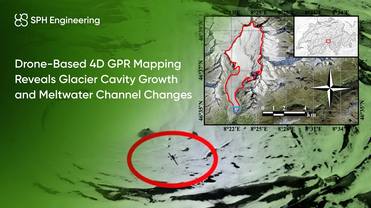
- Location & Date: Rhône Glacier, Switzerland, July-October 2022
- Application: Drone-based Ground Penetrating Radar (GPR) for cryospheric mapping
- Industry: Glaciology and Climate Research
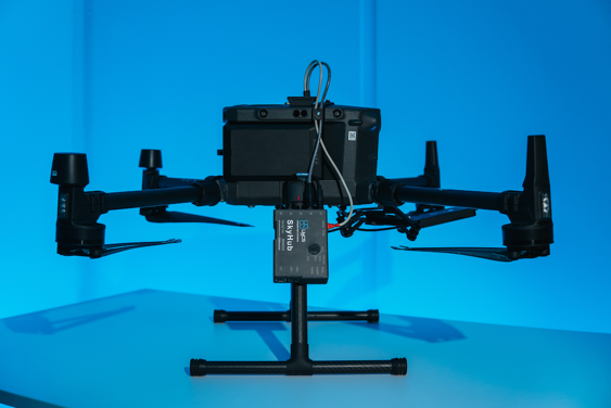
- Hardware: UAV equipped with custom-made 80 MHz GPR antenna + RTK GPS
- Software: UgCS with True Terrain Following (TTF)
- Survey Density: 1 m line spacing across four survey flights
- Outcome: 4D cavity model showing −68 % roof thinning and +16 % cavity growth
This project demonstrated the unique value of combining GPR sensors with drone automation for safe, high-resolution cryospheric mapping.
Background: Why Study Glacier Interiors
Glaciers are dynamic natural systems shaped by complex interactions between ice, water, air, and the underlying bedrock. These interactions strongly influence glacier movement, stability, and melting patterns. Beneath glaciers, hidden features such as drainage channels and cavities develop, affecting their behavior but are challenging to monitor directly.
Understanding what happens beneath the surface is critical for predicting glacier behavior and climate impact. Traditional ground surveys and boreholes provide only limited or risky access to hidden glacier features, as crevasses, unstable ice, and low data resolution make it difficult to detect subtle subglacial changes.
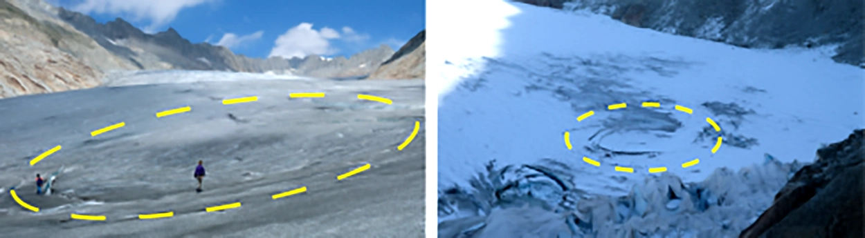
The Rhône Glacier in Switzerland has recently experienced several significant collapse events near its terminus. These collapses were primarily caused by rapid melting, structural weakening from thinning ice, and shifts in subglacial water flow paths.
A team from the University of Lausanne’s CRAG group therefore turned to UAV-based Ground Penetrating Radar (GPR) to reveal the hidden evolution of the glacier’s internal structure.

Subglacial Mapping Challenges
Monitoring a glacier’s hidden interior with precision radar sensors requires several environmental and technical challenges:
- Access difficulties. Crevasses and unstable surfaces make it dangerous and difficult for teams to safely reach and study key glacier areas.
- High data accuracy requirements. Understanding glacier features beneath the surface demands high-resolution data. Traditional methods often fail to provide sufficient detail, leaving critical gaps in understanding.
- Rapid changes over time. Internal glacier structures, like water channels and cavities, can change dramatically over short periods, sometimes within days or weeks. It requires frequent and consistent monitoring.
- Complexity in data interpretation. Differentiating between subsurface features like cavities, fractures, and water channels is complicated. Misinterpretations can mislead assessments of glacier stability and processes.
Drone-Based GPR Survey Solution
To overcome these barriers, researchers deployed a drone-based Ground Penetrating Radar (GPR) system designed for deep-ice imaging.
The UAV carried a custom-made 80 MHz antenna with precise RTK GPS positioning to detect structures tens of meters below the surface.
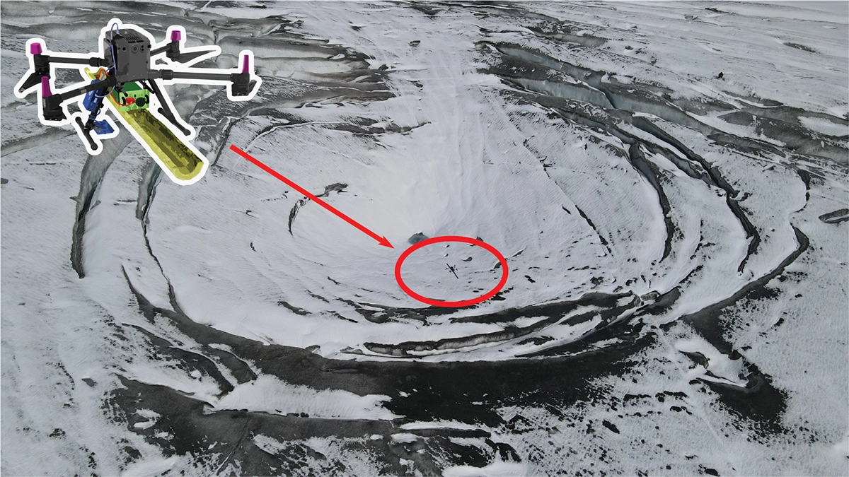
Flights were automated through UgCS flight planning software with SPH Engineering’s True Terrain Following (TTF), keeping the drone 5 m above ground level (AGL) even over highly uneven terrain. This ensured consistent radar coupling and signal quality while minimizing risk for operators on unstable ice.
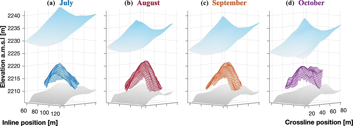
Between July and October 2022, the team conducted four high-density surveys with 1 m line spacing, creating a 4D dataset (3D over time) of the collapse feature.
Results and Data Insights
Precise Measurement of Cavity Formation
Drone-based GPR data clearly showed the growth of a cavity under the glacier surface, capturing the thinning of the ice roof from 9.6 meters in July to just 3.0 meters by October. Simultaneously, the cavity’s height expanded from 15.9 to 18.4 meters, highlighting significant melting and structural weakening.
Clear Tracking of Subglacial Channels
Using amplitude analysis, researchers accurately mapped the routes and transformations of water channels beneath the glacier. Over the summer, significant changes, including widening and straightening of channels, were clearly documented, correlating with increased meltwater flow and warm air exposure at the glacier’s front.
Detailed Visualization of Glacier Interior
High-density GPR profiles provided detailed views of the internal glacier, revealing new fractures, ice layers breaking away, and gradual sinking of the cavity roof. These images offered unprecedented clarity on how glacier collapses occur.

Conclusion
This project demonstrates the power of using advanced drone-based 4D GPR technology for high-resolution glacier mapping. Researchers successfully captured the detailed evolution of the Rhône glacier's collapse feature, avoiding limitations of traditional survey methods.
The study provided clear measurements of rapid ice thinning, cavity expansion, and evolving water channels beneath the glacier. These findings emphasize the valuable role of drone-based GPR systems in future glacier studies, improving the understanding of glacier stability and response to climate change.
Reference
Ruols, B., Klahold, J., Farinotti, D., & Irving, J. (2025). 4D GPR imaging of a near-terminus glacier collapse feature. The Cryosphere, 19, 4045–4059. https://doi.org/10.5194/tc-19-4045-2025
Supplementary videos and data animations of the Rhône Glacier study: https://zenodo.org/records/15652968
More about Bastien Ruols’ work: https://www.linkedin.com/in/bastien-ruols/