

Quick Facts
- Partner: Oseanland Survei Indonesia
- Location: PT Sulawesi Cahaya Mineral, Konawe, Southeast Sulawesi, Indonesia
- Application: Drone-based bathymetric surveying in swampy mining water bodies
- Challenge: Collecting bathymetric data in inaccessible water bodies, tailing ponds, and swampy zones where boats or USVs may be difficult or unsafe to deploy
- Solution: UAV-based Bathymetry kit deployed on DJI M350 RTK, integrated with SkyHub onboard computer and UgCS drone flight planning software
- Key Result: The trial demonstrated a safer and more accessible way to collect bathymetric data in challenging mining environments
Background: Bathymetric Surveying in Swampy Mining Areas
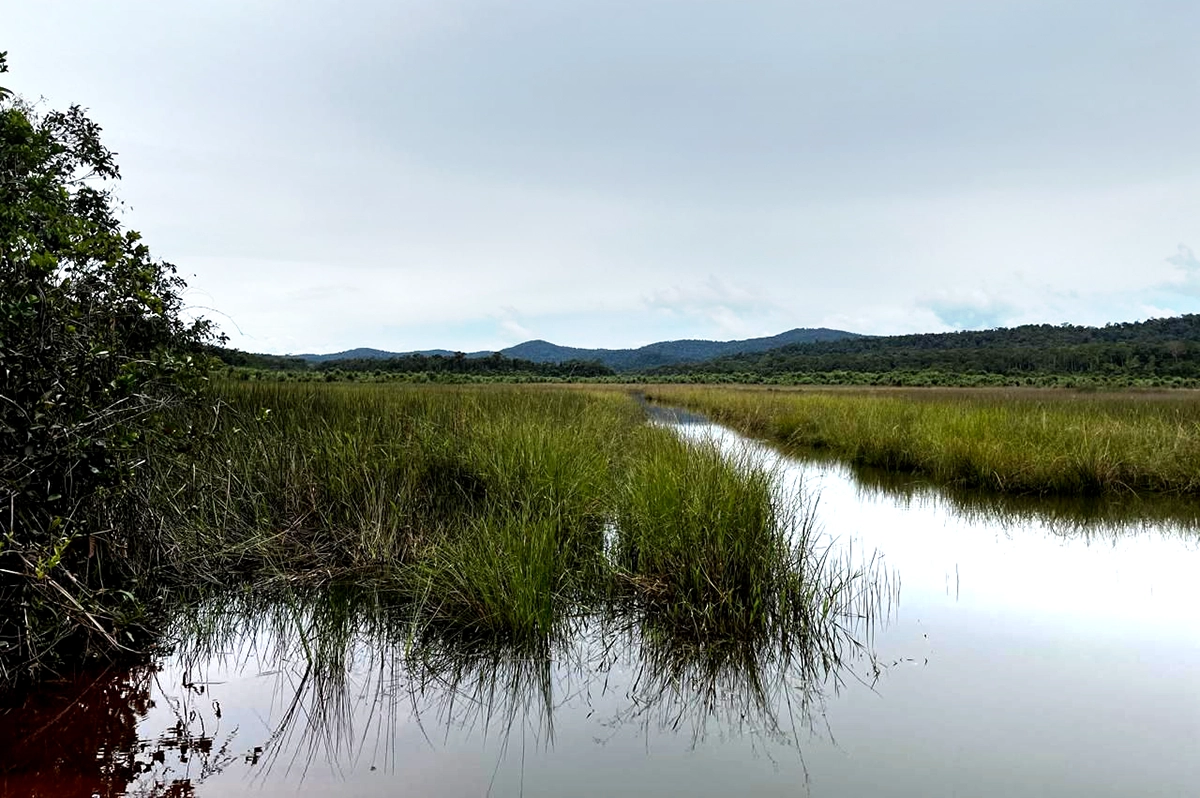
PT Sulawesi Cahaya Mineral operates a mining site in Konawe, Southeast Sulawesi, Indonesia. As in many mining environments, water bodies on or near the site may require bathymetric data to support monitoring, planning, and water management.
For this field demonstration, Oseanland Survei Indonesia tested drone-based bathymetry as a method for collecting depth measurements in a swampy mining water body. The demonstration focused on the use of a UAV-mounted echo sounder as part of an integrated workflow for bathymetric data acquisition.
The Challenge: Collecting Depth Data Where Access Is Limited
Bathymetric surveys in swampy mining environments can be challenging when water bodies are shallow, irregular, surrounded by dense vegetation, or located in terrain that is difficult to reach safely.
The main challenge was to evaluate whether bathymetric data could be collected without relying on boat-based access or placing survey teams directly in difficult field conditions.
Key access limitations included:
- Swampy terrain and soft ground around the survey area
- Limited suitability for boats or USVs in shallow or vegetation-covered water
The Solution: UAV-Mounted Echo Sounder Integrated with UgCS and SkyHub
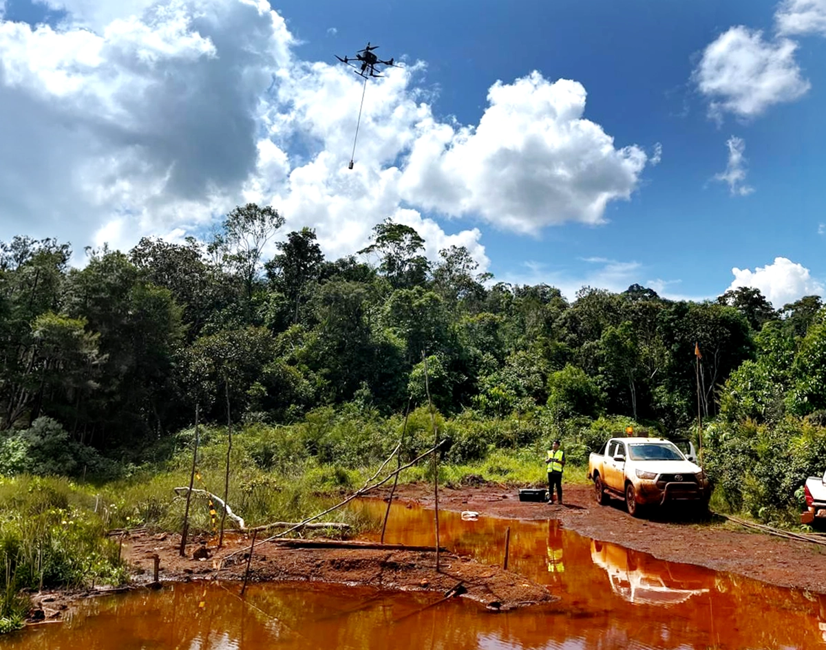
Oseanland Survei Indonesia deployed a DJI Matrice 350 RTK carrying an ECT D052S echo sounder. The payload was integrated with SkyHub, a radar altimeter, and UgCS mission planning software from SPH Engineering.

Together, these components supported a UAV-based bathymetry workflow in which the drone could fly over the target water body, maintain the required altitude, and collect georeferenced depth measurements without using a boat or USV.
The workflow supported:
- Planned flight lines over the survey area using UgCS mission planning software
- Controlled low-altitude operation with the radar altimeter and SkyHub integration
- Georeferenced depth data collection from the UAV-mounted ECT D052S echo sounder
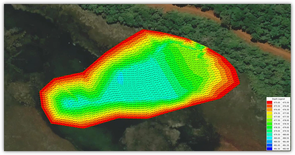
Results: Bathymetric Mapping Without Direct Water Access
The trial demonstrated that drone-based bathymetry can support depth data collection in swampy mining environments where conventional access is limited. The bathymetric map showed depth variations across the surveyed water body and helped visualize underwater conditions in an area that would be difficult to survey from the surface.
For mining operations, this approach can support:
- Safer fieldwork by reducing the need for personnel to enter difficult or hazardous water areas
- Faster deployment in locations where boats or USVs are impractical
Conclusion
The demonstration by Oseanland Survei Indonesia at PT Sulawesi Cahaya Mineral showed how drone-based bathymetry can support data collection in swampy and hard-to-access mining environments.
This case highlights the potential of UAV-based bathymetric surveying for mining water bodies and other industrial water management applications where safety and accessibility are major constraints.