Quick Facts
- Partner: Best Survey Mongolia
- Location: Oyu Tolgoi Mine
- Application: TSF drone-based bathymetric monitoring for water level monitoring
- Challenge: Safe data collection in a water pond within the TSF
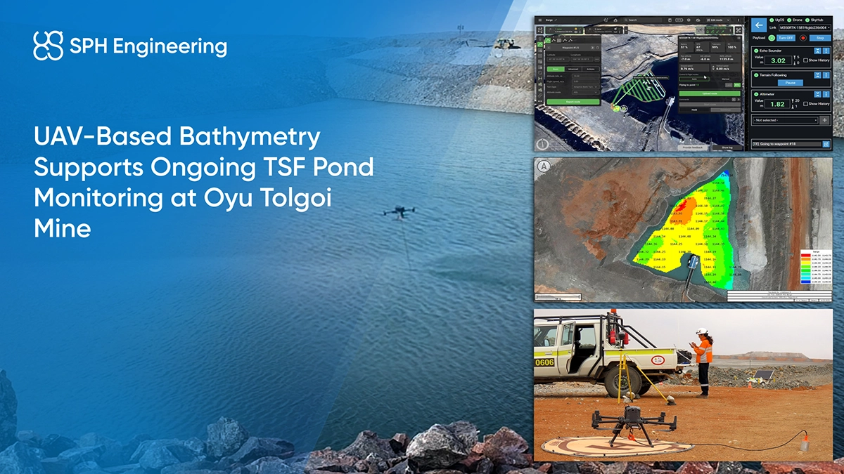
- Solution: UAV-based Bathymetry kit deployed on DJI M350 RTK, integrated with SkyHub onboard computer and UgCS drone flight planning software
- Key Result: Safe and effective water level monitoring achieved without boat-based operations
Background: Monitoring Requirements in Tailings Storage Facilities
As part of their work at the Oyu Tolgoi Mine, Best Survey’s team regularly conducts monitoring activities within the tailings storage facility.
Water bodies in TSFs require regular surveying to support water level monitoring,understand depth distribution, track changes over time, and support operational decision-making. Consistent bathymetric data is important for managing water levels, assessing capacity, and identifying potential risks such as uneven deposition or sediment accumulation.
In large-scale mining operations like Oyu Tolgoi, these tasks are part of routine site management and require reliable, repeatable survey methods.

The Challenge: Limitations of Traditional Bathymetric Surveys in TSFs
For monitoring this pond, conventional bathymetric surveys using crewed boats or USVs were not suitable, as there was no safe deployment point for a vessel of any size within the tailings storage facility. This limitation directly affected how surveys could be performed:
- Personnel exposure to risk: Boat-based surveys require personnel to operate from a vessel, which can increase exposure to site-specific risks.
- Limited accessibility: Certain areas of the pond may be difficult to reach due to shallow zones, geometry, or operational restrictions within the TSF.
- Operational complexity: Deploying and managing a boat adds logistical overhead, particularly in controlled industrial environments.
- Inefficiency for repeat surveys: Regular monitoring requires repeated mobilization, making traditional workflows less flexible over time.
Given these constraints, Best Survey needed an approach that would allow them to continue monitoring activities while reducing direct interaction with the water body.
Solution and Results: UAV-Based Bathymetric Survey Workflow
To address these challenges, Best Survey implemented a UAV-based bathymetric survey workflow for data collection within the TSF.
The DJI M350 RTK drone was equipped with an SPH Engineering bathymetry kit with ECT D052S echo sounder and deployed over the pond, where it collected depth measurements along predefined survey lines. The system is operated remotely, allowing the survey team to remain outside the survey area throughout the mission.

This workflow allowed the team to perform surveys without deploying boats, simplifying field operations and reducing exposure to site-specific risks. Thanks to UgCS flight planning software, data collection was carried out along structured survey lines providing consistent coverage of the monitored area.


As a result, the drone-based approach provided:
- Georeferenced bathymetric maps showing depth variation across the pond
- Safe data collection without water access
- A workflow aligned with ongoing monitoring needs

Conclusion
The project demonstrates a practical implementation of UAV-based bathymetry for TSF water level monitoring. The workflow supported structured data acquisition and reduced the need for vessel-based operations.