Introduction
Drones have moved far beyond photography and video. They're now essential tools in industries you might not expect—handling tasks like drone mapping, lidar scanning, and inspections using thermal images. Pilots using advanced drone software such as UgCS Open and UgCS Cloud (with cloud sync via DJI Pilot 2) have a competitive edge. They're running more precise missions, collecting better data, and making their workflows simpler. Let’s look at five surprising industries where drones have quietly become essential.
1. Powerline Inspections
Powerlines stretch for dozens or hundreds of kilometers, often along roads and remote corridors. Traditionally, inspections required vehicles, manual checks, and long hours. Today, drones equipped with lidar sensors are replacing these slow and expensive methods.
Drones deliver detailed maps of powerline corridors, with accurate ground sample distance (GSD). For pilots, the biggest challenge is planning long-distance flights. That's where drone software like UgCS makes a difference. UgCS lets you:
- Plan long corridor flights directly from CSV or KML files.
- Follow terrain closely, keeping consistent altitude and precise GSD.
- Work fully offline—caching maps for missions in remote areas without internet.

With UgCS, pilots spend less time planning and repeating flights, which saves money and improves data quality.
2. Renewable Energy: Faster Solar Panel Inspections with Thermal Drones
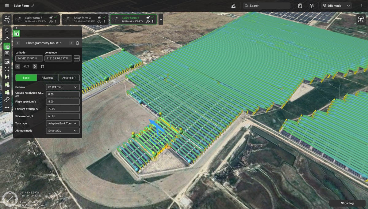
Inspecting solar farms was once slow and tedious. Technicians walked fields or used handheld infrared cameras. Now, drones with thermal cameras can detect problems in minutes, pinpointing faulty panels easily.
Professional drone pilots using UgCS gain advantages that other drone software can't offer, like:
- Automatically aligning drone flight paths parallel to panel rows.
- Precisely controlling the drone’s camera angle for accurate thermal images.
- Supporting custom payloads beyond DJI equipment.
This precision reduces human error, improves inspection speed, and keeps solar farms operating efficiently.

3. Construction: Vertical Dam Inspections Made Safer and Simpler
Inspecting large vertical structures—like dams—has traditionally meant engineers rappelling down, manually marking cracks. Drone photogrammetry eliminates these risky inspections by capturing precise images and creating accurate 3D models.
Using UgCS, pilots can run vertical drone mapping missions easily:
- The vertical scan tool ensures consistent GSD for accurate measurements.
- Repeatable missions make it simple to compare structural changes over time.
- Digital elevation models (DEM) imported directly into UgCS handle difficult terrain.
Inspectors get accurate data without risking their safety, plus measurable information on how structures change over time.
4. Mining: High Wall Safety with Drone Lidar Surveys
Open-pit mines are risky places. High walls can collapse unexpectedly. Accurate monitoring is critical, but traditional methods involve manual drone flights, which produce inconsistent data.
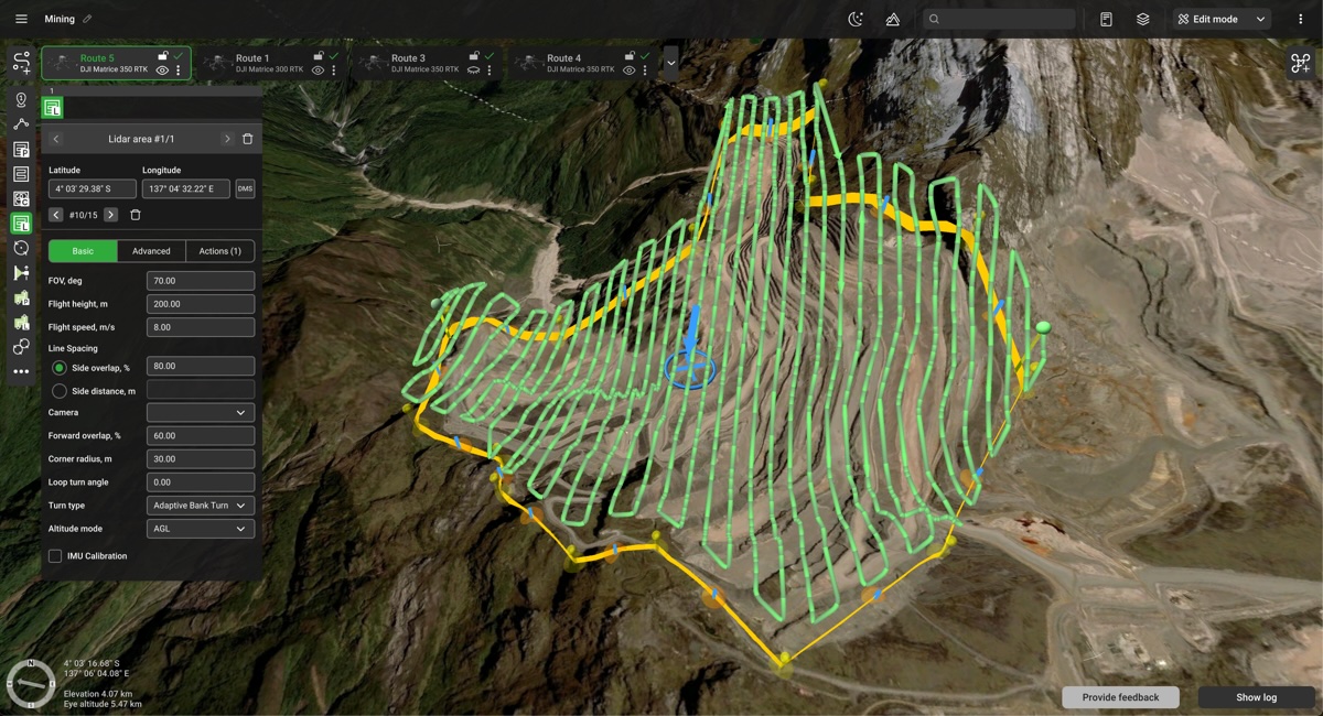
Drones carrying lidar sensors, combined with smart drone software like UgCS, solve these issues. UgCS helps mining operations by:
- Automating vertical scans, saving days compared to manual flights.
- Avoiding obstacles automatically is important in complex mining environments.
- Caching maps offline so missions can continue in remote mining locations.
These lidar drones improve mine safety, lower operational downtime, and reduce the risk of wall collapses.

5. Agriculture: Monitoring Plant Health Efficiently with Thermal Drones
Farmers traditionally spent hours or even days walking fields, manually checking crop health. Drones equipped with RGB or Multispectral cameras now provide faster, better monitoring over hundreds of hectares.
Pilots benefit from UgCS drone mapping features that competitors lack:
- Accurate terrain-following at low altitudes, ensuring consistent ground sample distance.
- Splitting large fields into smaller missions to improve efficiency.
- 3D flight planning directly from a desktop, ideal for large agricultural areas.
The result is accurate plant health data, faster decisions, and better crop yields.
Why Professional Pilots Prefer UgCS Drone Software
Choosing drone software matters. Professionals using UgCS have advantages competitors can't match, especially compared to DJI Pilot 2 or open-source solutions like QGroundControl. Here are the key reasons pilots switch to UgCS:
- Easy Customization: Flight plans in UgCS are fully cusomizable, including ability to combine multiple different mission segments and even convert missions to waypoints to fine-tune the flight path.
- Industry-leading terrain following. UgCS offers the best in industry algorithms and tools for drone terrain following. Starting from AGL tolerance, Smart AGL up to advanced trajectory adjustment for magnetic surveys and even real-time terrain following.
- Multi-Drone Flexibility: Missions created for DJI drones can be flown with other brands. No retraining needed when changing drone platforms.
- Offline Operation: Unlike DroneDeploy or DroneHarmony, UgCS works fully offline, perfect for remote locations with poor internet coverage.
- Superior LiDAR Tools: UgCS uniquely automates IMU calibrations (including figure-eight patterns) and flight smoothing for precise lidar data collection.
- Cloud Sync & Two-Pilot Workflow: UgCS Cloud integrates seamlessly with DJI Pilot 2, so one pilot flies while another plans the next mission. This saves valuable field time.
Advanced Features Unique to UgCS
Professional drone pilots appreciate unique features in UgCS that streamline their workflow, such as:
- DSM Support: Visualize buildings, trees, and structures directly in flight planning. Helps pilots avoid obstacles easily.
- Experimental Trajectory Smoothing: Prevents sharp maneuvers, protecting sensitive payloads like magnetometers or lidar sensors.
These advanced features help pilots complete complex missions successfully on their first attempt.
Conclusion: The Quiet Drone Revolution in Unexpected Industries
Drones, once considered a niche tool, are now vital in many industries—from mining to agriculture. Equipped with thermal cameras, lidar sensors, and sophisticated drone software, these tools simplify tough tasks, enhance safety, and save money.
Pilots using UgCS Open and UgCS Cloud are ahead of the curve. They're delivering accurate results faster, in situations others still manage manually.


