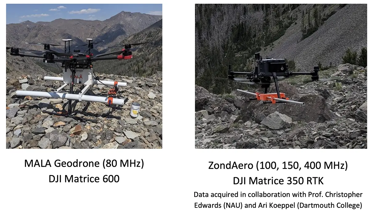
By integrating a MALA Geodrone 80 with a DJI Matrice 600 Pro via the SkyHub system, the team overcame the safety hazards and logistical limitations of traditional manual surveys. The mission delivered high-density subsurface data, revealing landform thicknesses of up to 48.6 meters in terrain that was previously inaccessible.
This is research-in-progress.
The Challenge: Hazardous Manual Traversal
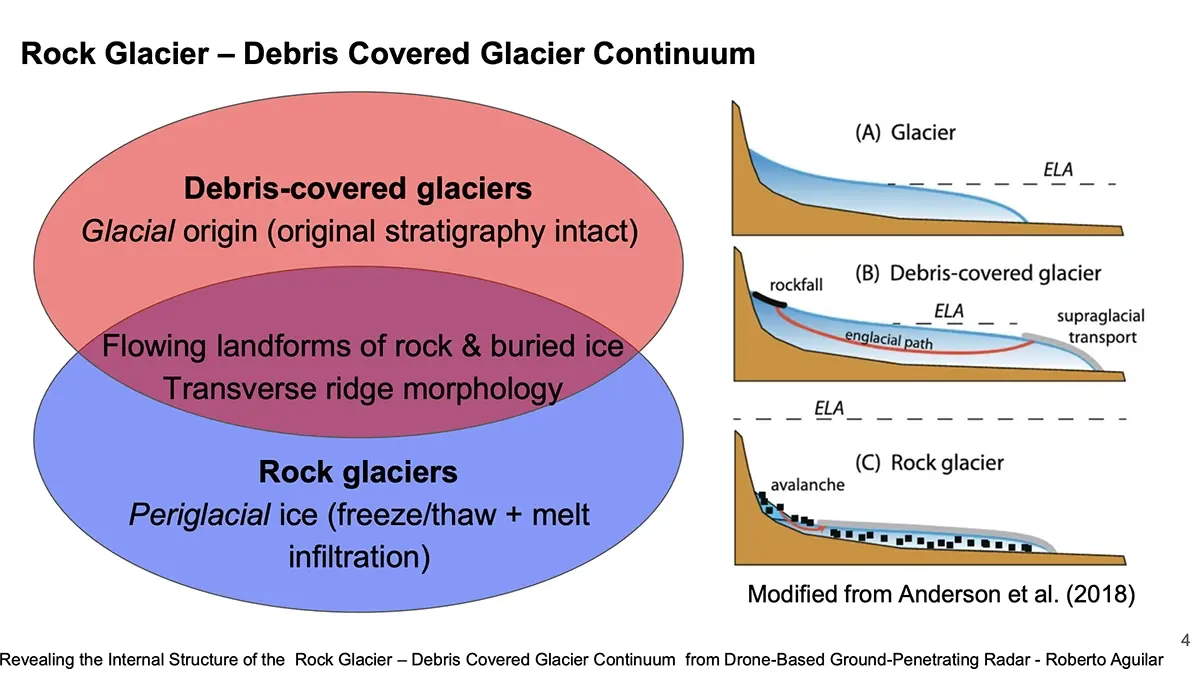
Understanding how rock glaciers and debris-covered glaciers (RG-DCGs) respond to climate warming requires precise subsurface characterization to quantify ice purity and total thickness - key parameters in both glaciology and alpine geology.
- Physics Constraints: GPR effectiveness is tied to altitude; the survey required a consistent flight height of approximately 3 meters above the surface to ensure clear signal penetration through the debris layer.
- Operational Risk: Traditional GPR requires researchers to manually drag antennas across the surface. At Sourdough and Galena Creek, this involves traversing rough, steep, and icy terrain that is often inaccessible to ground crews.
- Efficiency Gap: Manual surveys are time-consuming and limit the extent of the survey area, often resulting in sparse data sets that cannot fully represent the internal stratigraphy of the landform.
The Solution: The SkyHub + UgCS Integration for Safe, Efficient Subsurface Structure Mapping
To bridge the gap between hazardous manual labor and precision geophysics, the team deployed an integrated drone-based GPR system.
1. Automated Terrain Following via SkyHub
The SkyHub system with UgCS served as the critical link between the DJI Matrice 600 Pro and the MALA Geodrone 80.
- Reliable Navigation: The system enabled automated terrain following, allowing the heavy drone to "hug" the jagged topography of the glaciers at a consistent 3-meter altitude.
- Strategic Benefit: This eliminated the human error and safety risks associated with manual flying or ground surveys, ensuring a uniform dataset across the entire site.
2. High-Resolution Planning & Validation
The research workflow utilized high-resolution photogrammetry as a foundation for the geophysical survey.
- Pre-Flight Planning: Photogrammetry flights provided the necessary Digital Elevation Models (DEMs) to support flight planning within UgCS.
- Scientific Rigor: These DEMs were also required for clutter simulations, a vital step in validating that the detected englacial reflectors were genuine subsurface features rather than artifacts from surface boulders.

The Outcome: Precision at Depth
The drone-based approach to the subsurface glacier survey successfully covered large extensions of the glaciers with a data density that ground teams could not achieve.
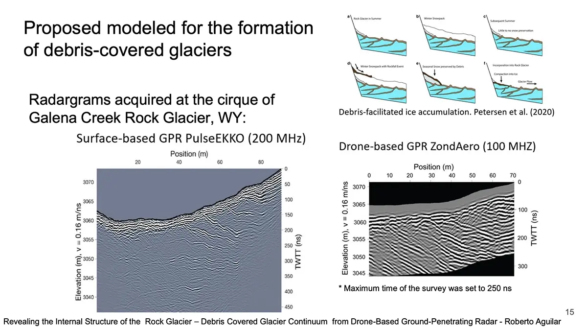
- Measured Thickness: The GPR system revealed a maximum thickness of 28.5 meters at Sourdough (AK) and 48.6 meters at Galena Creek (WY).
- Internal Stratigraphy: The data allowed researchers to quantify supraglacial debris thickness and assess ice purity by identifying distinct englacial reflectors.
- Operational Efficiency: The team gained access to steep, rough, and icy terrain that was previously categorized as "inaccessible”.
Why the SPH Engineering Bundle?
This mission proves that for high-stakes geophysics, the flight platform must be as sophisticated as the sensor.
- UgCS provided the mission planning flexibility to handle custom DEMs for low-altitude safety.
- SkyHub delivered the hardware integration required for automated, terrain-aware data collection.
- True Terrain Following - enables a drone to automatically maintain a consistent altitude above ground or water based on real-time altimeter readings.
By combining these tools, the University of Arizona transformed a dangerous physical task into a repeatable, high-fidelity aerial survey.
Skyhub & UgCS support all newest DJI Enterprise drones including M400, M350, M300.
Revealing the Internal Structure of the Rock Glacier - Debris Covered Glacier Continuum from Drone-Based Ground-Penetrating Radar Lead Author: Roberto Aguilar, John Holt, et al.Institution: University of Arizona (Department of Geosciences / LPL) Year: 2026
Source: Aguilar, R., Holt, J., Christoffersen, M., Meng, T., & Nerozzi, S. (2026). Revealing the Internal Structure of the Rock Glacier - Debris Covered Glacier Continuum from Drone-Based Ground-Penetrating Radar. University of Arizona; Georgia Institute of Technology; Washington University in St. Louis.
Solution Used: UgCS