
Mission Summary
Key Results
- 64% faster flight time compared to standard oblique missions
- 83% reduction in processing time (54 min vs. 5h 21min)
- 78% fewer images required while maintaining accuracy
- 1.38-1.53 cm RMSE (matching traditional methods)
- 50% smaller ground footprint outside survey boundaries

The Challenge: 3D Mapping in Tight Agricultural Spaces
Christmas tree orchards (conical dense vegetation) present a uniquely difficult test case for drone photogrammetry. Balsam firs grow in dense, conical shapes with uniform foliage that creates occlusion problems from standard flight angles. The trees are packed into tight rows, and the terrain beneath them is uneven, often carved from former woodlots.
Traditional grid-based flight patterns struggle in these environments. Standard oblique missions require extensive overshoot beyond survey boundaries, sometimes extending 50-60 meters on each side just to capture adequate imagery. This becomes impractical in constrained survey areas where neighboring properties, roads, or obstacles limit where a drone can fly.
The Dalhousie research team needed to map a 2.45-hectare orchard containing approximately 450 trees. The field measured 93 meters wide and 131 meters long, with a 7% slope from north to south. They wanted to know: could Circlegrammetry deliver the same reconstruction quality as traditional methods while using less airtime?
How UgCS Circlegrammetry Works
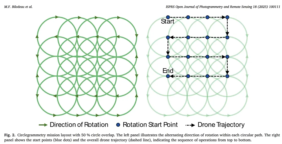
Circlegrammetry, introduced by SPH Engineering in UgCS version 5.5, offers an alternative to standard survey grids by utilising circular flight patterns to cover an area. The drone flies to the edge of each circle, then orbits with its camera angled 45-70 degrees toward the center. After completing one circle, it transitions to the next adjacent circle without stopping and repeats the pattern.
This creates what photogrammetry specialists call "convergent geometry." Image rays from opposite sides of each circle intersect at steep angles, which allows Structure from Motion software to triangulate 3D positions with high precision. The circular pattern captures every object from multiple viewing directions without requiring the drone to fly far beyond the survey area.
The method is particularly well-suited for capturing oblique imagery of structures and complex vegetation. Where traditional nadir (straight-down) imagery struggles to see the sides of trees or buildings, Circlegrammetry's inward-facing oblique angles capture these surfaces directly and manage to do so from more different angles compared to standard approach
The Experiment: Five Flight Methods, Head-to-Head
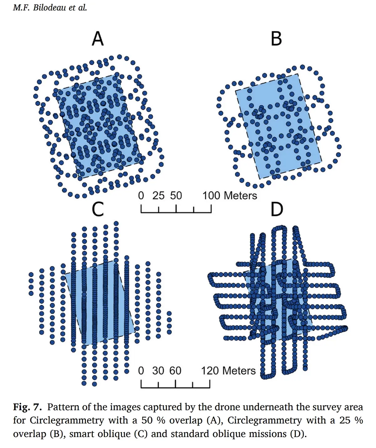
The research team conducted five separate drone missions over the same orchard on April 4, 2025. Three used UgCS Circlegrammetry at different settings. Two used DJI Pilot 2 for standard and smart oblique patterns. All flights used identical hardware: a DJI Matrice 300 RTK with a Zenmuse P1 camera (45 megapixels, full-frame sensor).
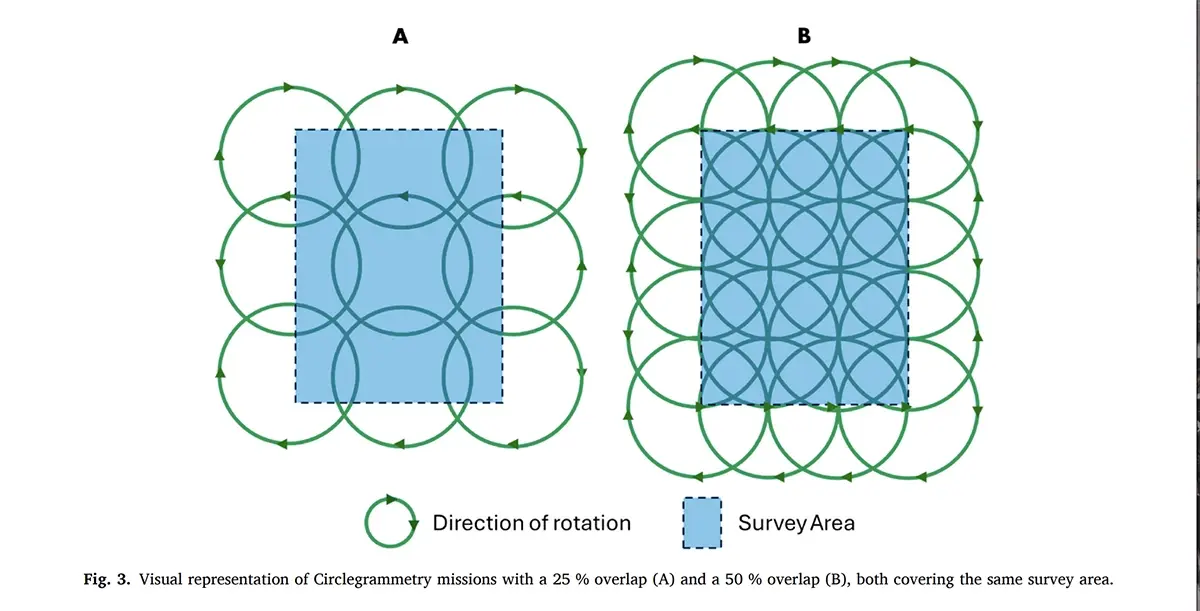
The test configurations included Circlegrammetry at 40m altitude with 50% circle overlap, Circlegrammetry at 60m with 50% overlap, Circlegrammetry at 60m with 25% overlap, standard oblique at 60m, and DJI Smart Oblique Capture at 60m. Eight ground control points were surveyed with RTK-GNSS to validate accuracy.
Results: Flight Time and Efficiency
The efficiency gains were immediate and measurable. Circlegrammetry with 25% overlap completed the entire survey in 4 minutes and 10 seconds - a 64% reduction compared to standard methods. The standard oblique mission took 11 minutes and 41 seconds to cover the same area.
The difference in required boundary extension was equally striking. Standard oblique missions extended 58 meters beyond the survey area on each side. Circlegrammetry with 50% overlap extended only 28 meters horizontally and 24 meters perpendicularly. For a field just 93 meters wide, this reduction in overshoot represents the difference between feasible and impractical operations in constrained spaces.
Reconstruction Accuracy: No Trade-Off Required
The critical question for any automated flight planning is whether speed gains come at the expense of data quality (RMSE). In this study, they did not.
Ground control point RMSE values ranged from 1.38 to 1.53 centimeters across all five methods. The researchers found no statistically significant difference in tree height measurements (Kruskal-Wallis H = 2.13, p = 0.545) or point cloud density. Median tree heights ranged from 4.82 to 4.95 meters across all approaches.
Circlegrammetry at 50% overlap produced results statistically indistinguishable from DJI Smart Oblique Capture. Both methods showed nearly identical point spacing across different canopy heights. The research paper states this directly: "Circle 50% missions yielded comparable results to Smart Oblique missions."
Practical Considerations for Operators
The study identified one trade-off worth noting. Circlegrammetry missions captured fewer points in the lower canopy compared to traditional oblique methods. This happens because the inward-facing camera angle primarily sees the tops of trees. Upper branches block views of lower vegetation.
For applications where lower canopy detail is critical, the researchers suggest combining Circlegrammetry with additional low-angle passes around the perimeter. This hybrid approach would add some flight time but could improve coverage beneath the crowns.
The study also found that 50% circle overlap provided the best balance between efficiency and reconstruction quality. At 25% overlap, flights were fastest, but point spacing increased noticeably in lower canopy regions.
Why This Matters for Drone Operators
Circlegrammetry addresses a specific pain point that grid-based flight planning cannot solve: constrained survey areas. When a field is bordered by obstacles, property lines, or no-fly zones, the extensive overshoot required by traditional oblique missions becomes a liability.
The efficiency gains compound across a typical workday. Faster flights mean more sites surveyed per battery charge. Shorter processing times mean results delivered sooner. For commercial operators billing by project, these improvements translate directly to margin.
The peer-reviewed validation matters too. This research was conducted independently by Dalhousie University and published in the ISPRS Open Journal of Photogrammetry and Remote Sensing, one of the field's primary academic venues. The findings are reproducible and the methodology is documented for verification.
From the Researchers
"Circlegrammetry emerges as a promising method for precision agriculture applications by striking a balance between flight efficiency and reconstruction detail. Circlegrammetry with a 50% overlap was demonstrated to be a comparable alternative to the smart oblique acquisition method."
— Bilodeau et al., ISPRS Open Journal of Photogrammetry and Remote Sensing, 2025
Technical Specifications
- Platform: DJI Matrice 300 RTK
- Sensor: DJI Zenmuse P1 (45 MP, full-frame, 35mm lens)
- Flight Planning: UgCS 5.5 (Circlegrammetry), DJI Pilot 2 (oblique missions)
- Processing: Agisoft Metashape v2.2.0
- Circle Radius: 30 meters
- Gimbal Pitch: 45 degrees (all missions)
- Flight Speed: 8.2 m/s
- Survey Area: 2.45 hectares (93m × 131m)
Citation
Bilodeau, M.F., Esau, T.J., MacDonald, M.T., & Farooque, A.A. (2025). Circlegrammetry for drone imaging: Evaluating a novel technique for mission planning and 3D mapping. ISPRS Open Journal of Photogrammetry and Remote Sensing, 18, 100111.
DOI: 10.1016/j.ophoto.2025.100111
This case study is based on open-access research published under the CC BY-NC-ND 4.0 license. The original authors and Elsevier B.V. are credited. No use, distribution, or reproduction is permitted which does not comply with these terms.
PANEL: SOLUTION USED, UgCS