

Quick Facts
- Project Type: UAV-based magnetometry survey
- Location: California, USA
- Environment: Agricultural wetlands and rice fields
- Survey Area: ~2,200 acres (targeted survey blocks)
- Solution: Targeted low-altitude UAV magnetic surveys using SPH Engineering’s MagNIMBUS integrated system mounted on DJI Matrice 350 RTK with SkyHub onboard computer and UgCS flight planning software.
- Challenge: Locating abandoned gas wellheads with uncertain surface visibility due to agricultural activity and irrigation infrastructure.
- Key Result: 22 of 25 abandoned wells were successfully detected
Background: Abandoned Gas Well Identification in a Large Wetland Restoration Area
The survey was conducted within a wetland restoration area primarily used for rice cultivation and seasonal waterfowl hunting. While the state of California maintains a GIS database of abandoned gas wellheads throughout the Central Valley, the accuracy of recorded locations varies significantly. The California Department of Conservation identified 25 abandoned gas well locations within the project area, but their precise surface positions remained uncertain. Reliable identification of well infrastructure was therefore required before restoration and construction activities could proceed.

The Challenge: Locating Abandoned Gas Wellheads and Subsurface Infrastructure in Agricultural Wetlands
Several factors complicated the identification of abandoned gas wellheads:
- Many wells were no longer visible at the surface due to agricultural activity and sediment accumulation
- Irrigation channels and metallic agricultural features introduced magnetic noise
- Wetland conditions limited access for ground-based surveys
- Surveying the full 2,200-acre site using traditional methods would be inefficient and disruptive
A focused, non-invasive survey method was needed to reliably locate wellheads while minimizing field time and site disturbance.
The Solution: Targeted UAV-Based Magnetometry Survey Design
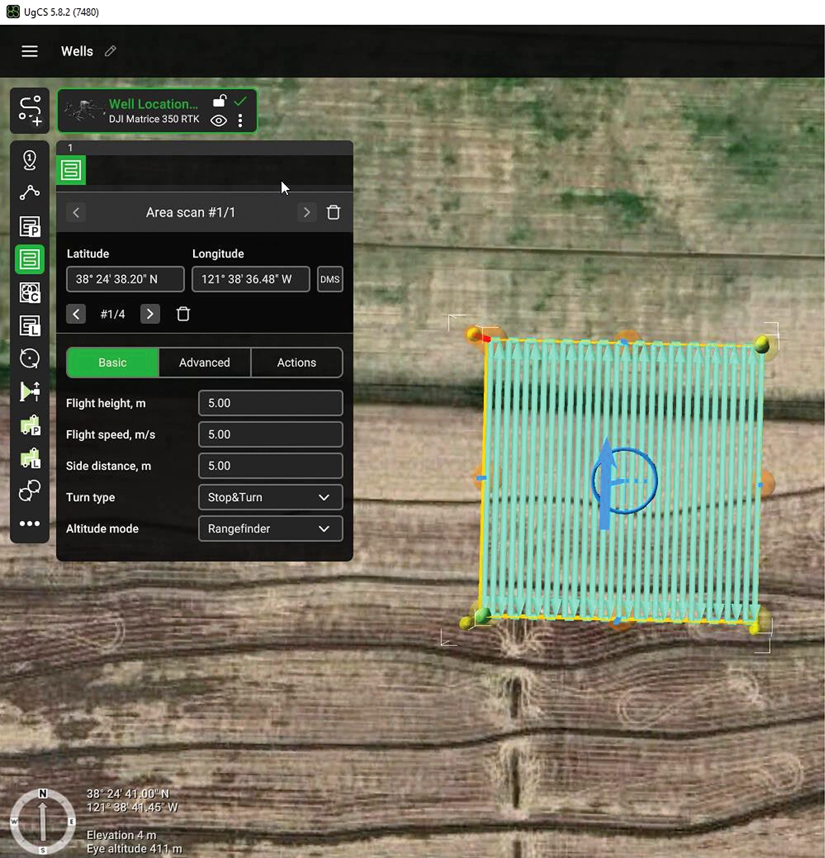
To address site access and efficiency constraints, a targeted UAV-based magnetometry approach was adopted. Surveys were conducted using a DJI Matrice 350 RTK platform equipped with SPH Engineering’s MagNIMBUS magnetometry system and SkyHub onboard computer. Flight planning and execution were carried out using the UgCS flight control software, enabling systematic low-altitude coverage and consistent line spacing across individual survey blocks.
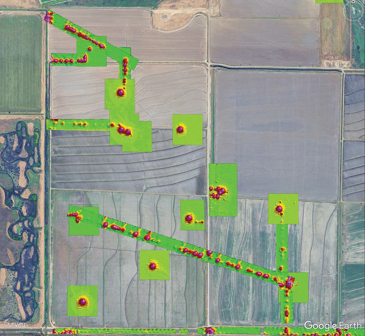
Instead of surveying the full 2,200-acre site, individual 500 ft × 500 ft areas were flown over known and suspected well locations. This approach allowed focused data collection while maintaining high magnetic anomaly resolution.
Key survey parameters included:
- Low-altitude flights (~5 m above ground level)
- Tight line spacing (~5 m)
- Targeted survey blocks centered on known well coordinates
Post-processing workflows were applied to correct for platform-related interference and diurnal magnetic variation before interpretation.
Data Collection and Processing: Field Operations and Magnetic Data Correction
Data acquisition was completed over four total field days:
- Three days of initial surveying covering 25 well locations
- One return day to further investigate features identified during processing
- Approximately 35 UAV flights, averaging 20 minutes per flight
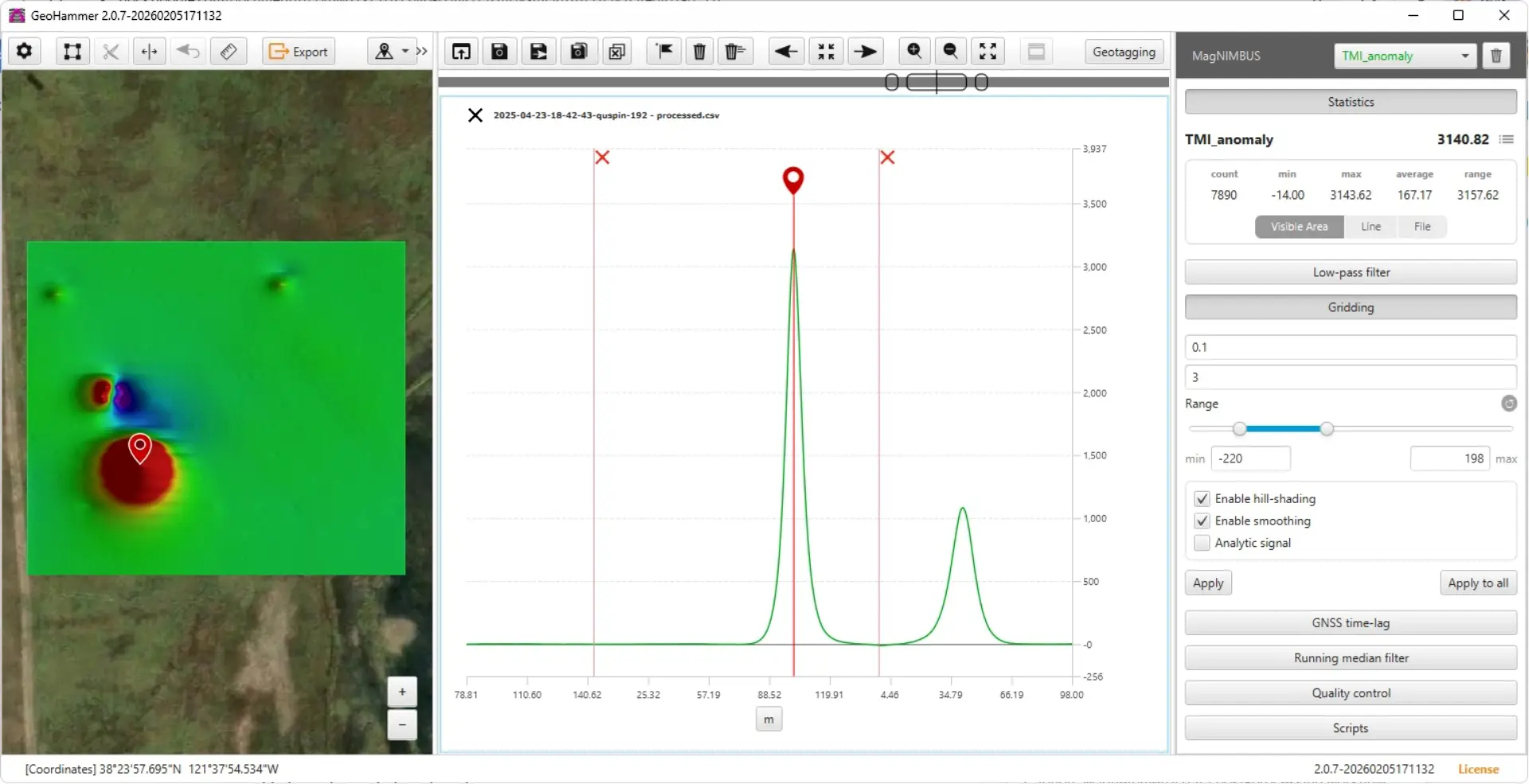
The project was managed by Michael Detwiler (formerly of Wood Rodgers), with UAV flight operations conducted by pilot Vitaliy Kosovan. SPH Engineering, which provided remote support, used GeoHammer for quick data assessment and suggestions.
Full processing was conducted using Oasis montaj to correct and filter sources of noise and error, including:
- GNSS time lag
- UAV motor electromagnetic interference
- Stationary data artifacts
- Diurnal magnetic field variation recorded by a base station
Results: Detection of Abandoned Gas Wells and Associated Subsurface Infrastructure
The UAV-based magnetic surveys produced the following results:
- 22 of 25 abandoned gas wells were successfully detected
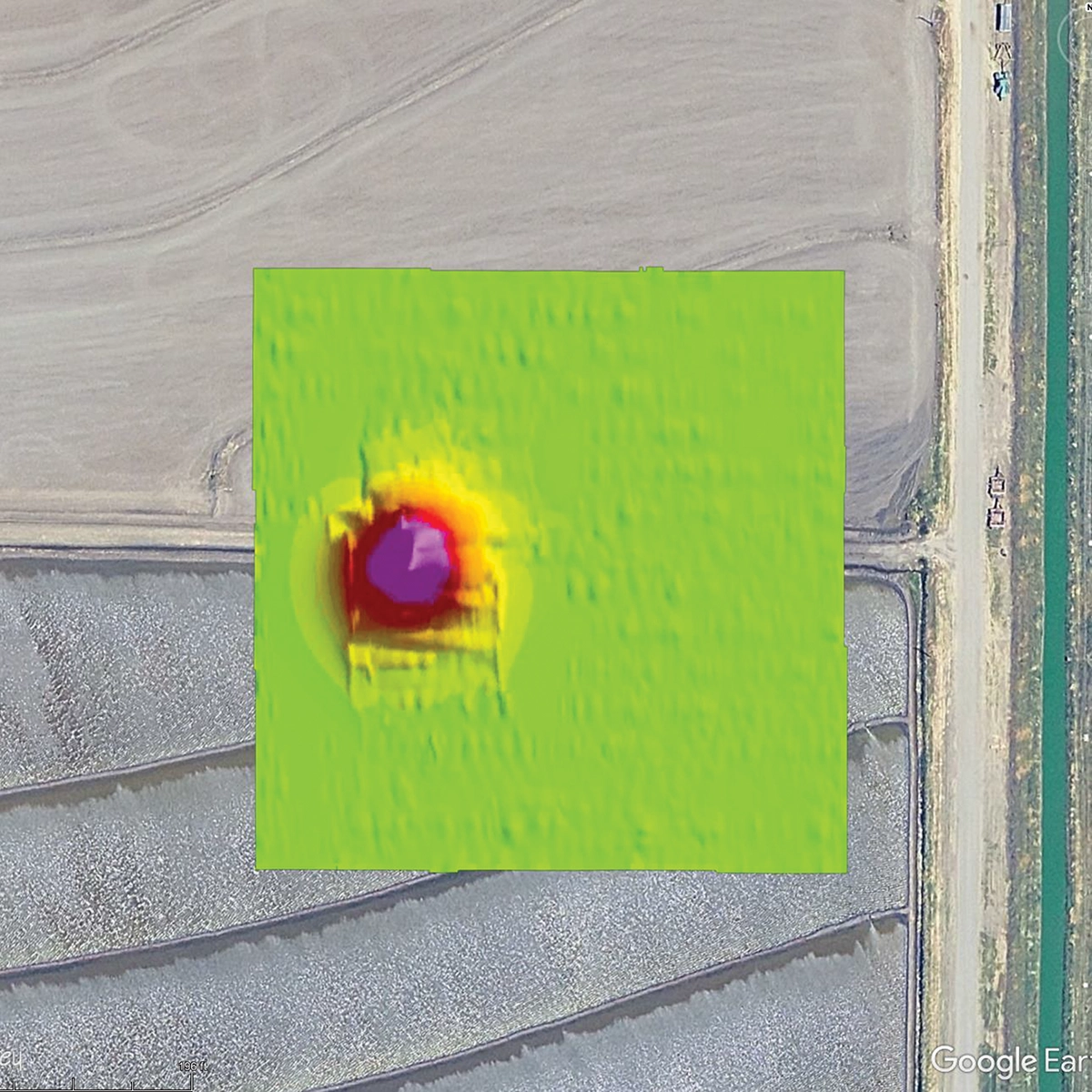
- Two well locations showed no detectable anomaly within the initial 500 ft × 500 ft survey area
- One well was partially obscured by nearby irrigation infrastructure
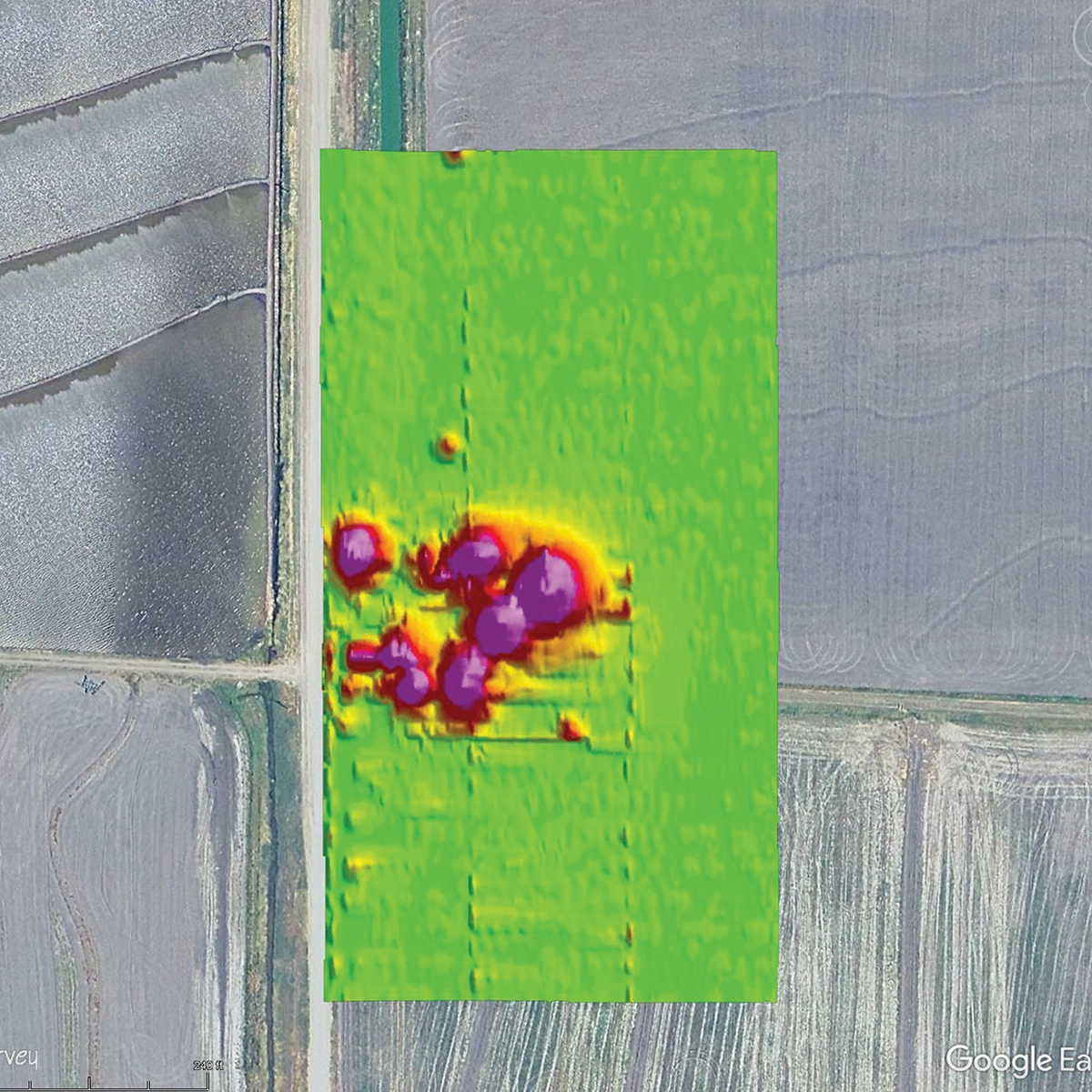
- Seven horizontal pipelines associated with historical gas infrastructure were identified
Conclusion: UAV-Based Magnetometry for Abandoned Gas Well Detection in Wetland Environments
This case study demonstrates that targeted UAV-based magnetic surveys can effectively locate abandoned gas wellheads and associated infrastructure in agricultural wetland environments. By concentrating survey effort on known and suspected locations, the approach reduced field requirements while delivering reliable subsurface detection results to support wetland restoration and land-use planning.