

.webp)
A note from Kristaps, UgCS Product Owner
For over a decade, I’ve had the privilege of watching the drone industry evolve. I remember when professional drone mapping required large, complex, and expensive machines that were out of reach for most. Today, I can hold a drone that contains more powerful camera technology than many of those early pioneers.
This shift is more than just a marvel of miniaturization; it’s a fundamental change in our industry. We are seeing the rise of powerful, backpack-sized drones that are democratizing access to professional aerial data. For years, the one thing holding these incredible machines back was their software. They were seen as tools for hobbyists, not for serious drone surveying.
At UgCS, we believe that professional-grade work should not be limited by the size of your drone. With the right drone software, we can unlock the full potential of these small aircraft and, in doing so, unlock a new world of opportunity for pilots everywhere.
The Rise of the "Prosumer" Powerhouse
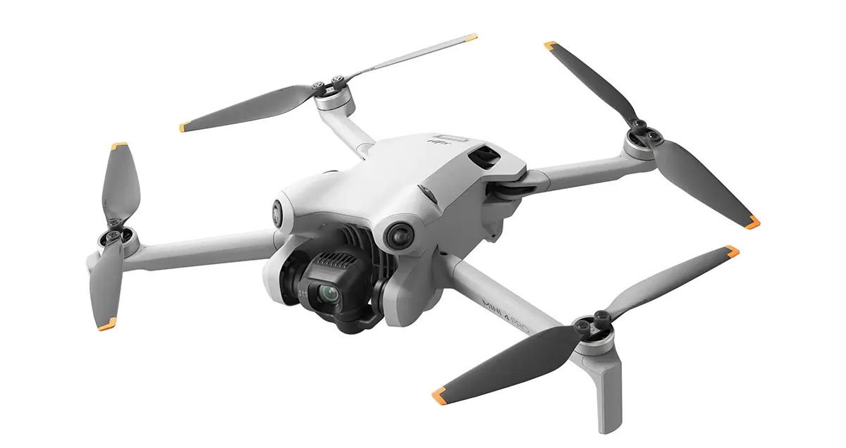
The performance packed into modern small drones is simply astounding. Models like the DJI Mini 4 Pro, Mini 3 Pro, Air 3, and Air 2S are no longer just for capturing vacation photos. With high-resolution cameras, advanced sensors, and incredible stability, they are technically capable of capturing data suitable for professional work.
Their advantages in the field are undeniable:
- The ability to carry an entire aerial mapping setup in a small backpack is a huge advantage for jobs in difficult-to-access locations.
- The reduced price point significantly lowers the barrier to entry for new pilots starting a business or for established companies looking to expand their fleet
- A smaller drone is less intimidating to the public and can be deployed with less disruption, which is ideal for work in populated areas.
However, a great camera is only half the story. The critical missing piece has always been the ability to fly automated, pre-planned missions with the precision required for professional outputs. Manually flying a grid pattern is inconsistent, inefficient, and simply not good enough for creating accurate maps or 3D models.
How Software Unlocks Professional Drone Surveying
This is the gap we set out to close. A drone is only as smart as the software that guides it. We knew that if we could give these small drones the "brain" of a professional mission planner, we could transform them into serious tools.
The UgCS and Litchi Workflow: A Simple Solution
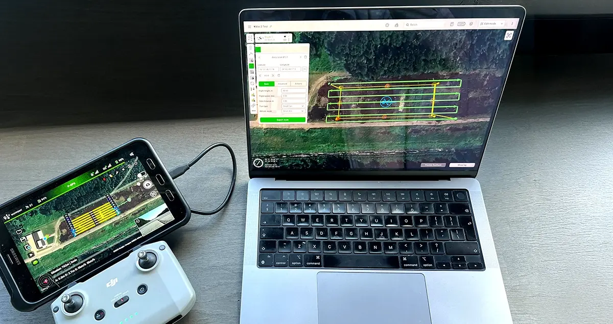
Through a simple yet powerful workflow, we've made this possible. By connecting our professional desktop planner, UgCS, with the widely-used Litchi app, pilots can now plan complex missions and fly them with their DJI Mini or Air series drones.
The process is straightforward:
- Plan Like a Pro in UgCS: You design your mission on your desktop with the full suite of UgCS tools. You can create precise photogrammetry grids, detailed corridor scans, or complex waypoint routes with full control over every parameter.
- Export the Mission: UgCS exports the flight plan as a KML file
- Fly with Litchi: You import the KML file into Litchi's Mission Hub, which then syncs to the mobile app. Litchi acts as the bridge, executing the professional mission you planned in UgCS.
Planning Like a Pro, Flying Like a Mini
This simple connection is revolutionary because it means you can now perform true, professional drone photogrammetry with a DJI Mini. The limitations are gone.
With UgCS, you can now use your small drone to plan and execute missions that were previously only possible on enterprise-level hardware. You can precisely control the ground sample distance (GSD) for your imagery, ensure your flight lines have the exact side and forward overlap required, and automate the entire capture process. This makes UgCS the essential photogrammetry software for unlocking DJI Mini surveying and DJI Mini mapping capabilities.
New Opportunities: The Jobs You Can Now Do With a Small Drone
This new accessibility opens up a range of professional services that are perfectly suited for smaller drones. The ability to offer fast, affordable, and high-quality aerial data can be a powerful business advantage.
Consider these job possibilities:
- Small Construction Sites. Quickly and easily conduct weekly progress reports, measure stockpiles, and create as-built models without needing a large, expensive drone.
- Real Estate Marketing. Go beyond simple photos. Offer clients stunning 3D models and accurate orthomosaic maps of their properties, all captured in a single automated flight.
- Roof and Façade Inspections. Plan safe, repeatable inspection routes to check for damage on residential or small commercial buildings, eliminating the safety risks of ladders.
- Local Public Safety. Document accident scenes or provide situational awareness for small-scale events without the complexity of deploying a large enterprise aircraft.
- Precision Agriculture. Monitor the health of specific crop plots or small vineyards with a level of detail and repeatability that manual flight could never match.
For each of these applications, the key differentiator is the professional deliverable. A client will always be more impressed with a precise 3D model or a perfectly stitched map than with a handful of manually captured photos.
A New Era of Accessibility
At its best, technology empowers people by making powerful tools more accessible. The rise of small, capable drones is a perfect example of this. At UgCS, we are incredibly excited to be part of this movement. By providing the professional drone software that bridges the gap between consumer hardware and professional results, we are helping to create a new generation of drone entrepreneurs.
The revolution is here, and it fits in your backpack.