
.webp)
Traditional ground surveys are often grueling, slow, and inherently invasive. To solve this, Dr. Best’s team turned to a drone-based multispectral workflow, using UgCS flight planning software as the technical foundation for their environmental and ecological research.
Summary at a Glance
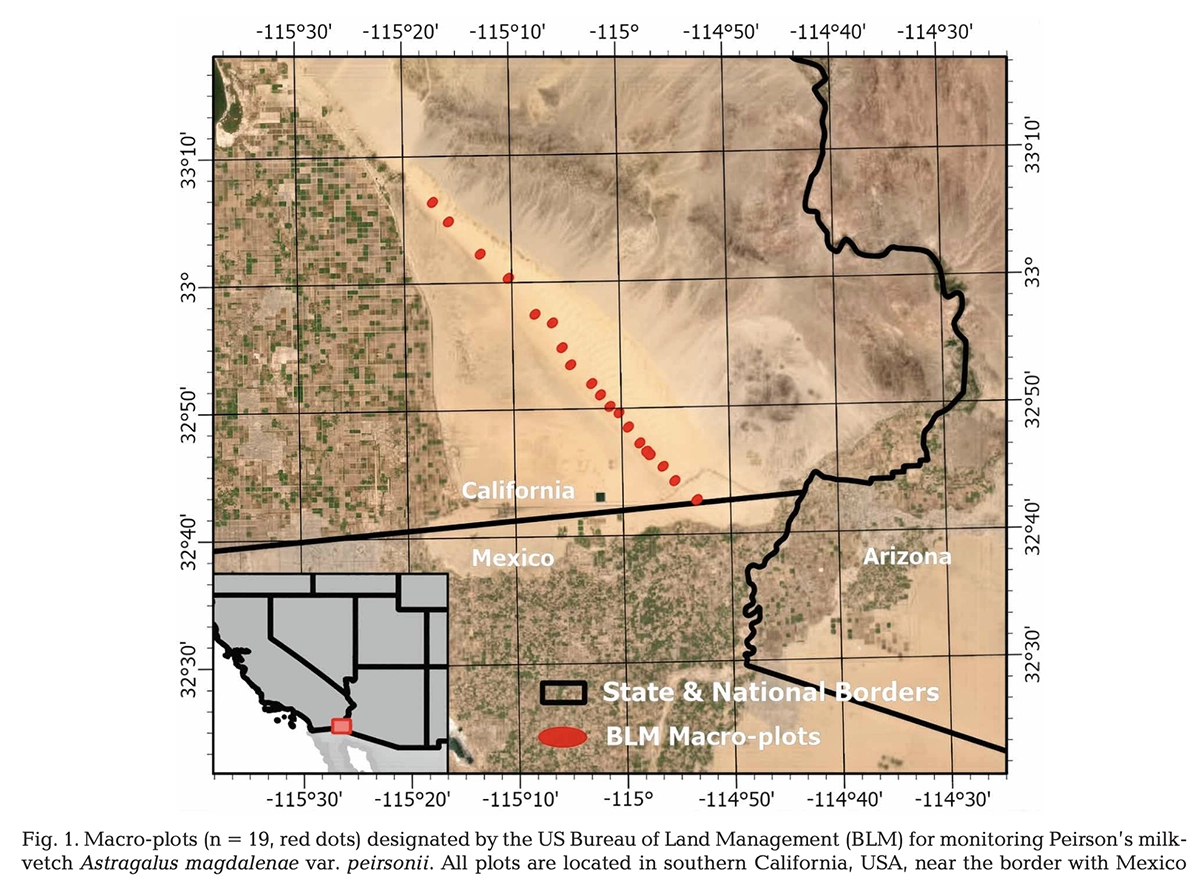
- Objective: Enable long-term, non-invasive monitoring of the endangered Peirson’s Milkvetch in a dynamic desert environment.
- Challenge: Achieve repeatable, high-resolution drone surveys in shifting sand dunes where terrain movement breaks standard flight planning tools.
- Solution: Used UgCS to plan and re-fly identical multispectral drone missions with terrain-aware altitude control and consistent ground sampling distance (GSD).
- Result: 93.25% average detection accuracy using a Random Forest classification model, enabling reliable, data-driven conservation monitoring.
- Impact: The workflow demonstrates how precision drone mission planning can replace invasive ground surveys for endangered species monitoring at scale.
The Challenge: Repeatable Drone Monitoring in a Dynamic Desert Environment
The study required tracking individual plants over a three-year period to assess population trends. In a "dune landscape" where the ground literally moves, standard flight apps often fail. The team needed:
Exact Repeatability.
To compare data year over year, the drone had to fly identical, precise grid patterns.
Uniform Resolution.
To identify a single plant, the Ground Sampling Distance (GSD) had to remain constant despite elevation changes in the dunes.
Complex Sensor Support.
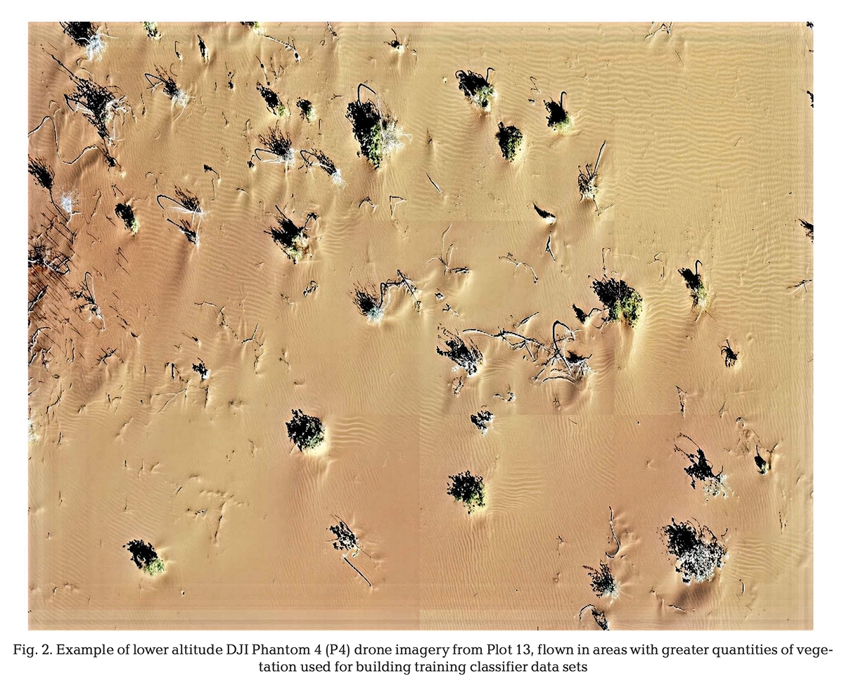
The mission relied on multispectral imagery to identify the unique spectral signature of the milkvetch plant against the sand.
The Solution: Precision Drone Mission Planning with UgCS
Dr. Best described UgCS as "invaluable" for the project’s success. The software provided several mission-critical features that enabled the team to meet the high standards of a peer-reviewed journal.
1. Advanced Terrain Following via DEM Import
In dune environments, maintaining a constant altitude Above Ground Level (AGL) is nearly impossible with standard barometric sensors. UgCS allows users to import high resolution Digital Elevation Models (DEMs) to ensure the drone follows the actual contours of the land.
- How it works: By importing a high-resolution DEM/DTM/DSM, UgCS is able to calculate a precise flight path that closely follows the terrain, even at low altitudes.
- The Impact: For Dr. Best, this ensured a constant GSD across the entire site. This was critical for the Random Forest classification model to accurately identify plant sizes and health indices. This same feature is used by search and rescue teams to fly safely in rugged mountains where the elevation is over 11,000 feet.
2. Multi-Year Mission Repeatability
Long-term environmental monitoring requires consistency. UgCS saves every flight parameter, allowing pilots to re-fly the exact same route months or years later.
- The Impact: The team conducted a 3-year study evaluating the feasibility of modeling individual PMV. Because the flight paths were identical, the researchers could definitively say whether population changes were biological rather than the result of shifting camera angles or inconsistent overlaps.
3. Precise Photogrammetry Grids for Multispectral Sensors
Multispectral sensors often have different field-of-view (FOV) requirements than standard RGB cameras. The Photogrammetry tool within UgCS allows pilots to define specific overlap requirements (forward and side) and camera trigger patterns based on the sensor's exact specifications. Any custom sensor can be used with UgCS.
- The Impact: High-resolution geometric and radiometric data are the optimal training features for classification models. UgCS enabled the team to isolate the best-performing variable combinations, including multispectral bands and vegetation indices, to reach their accuracy targets.
4. Fully Offline Operations
The Imperial Sand Dunes are remote, with little to no cellular coverage. Unlike cloud-dependent apps, UgCS is a desktop-grade software that runs locally.
The Impact: The team could plan, modify, and upload missions in the field without an internet connection. This eliminated the risk of being "locked out" of the software in the middle of a multi-day survey, a common failure point for apps that require a login to function.
The Results: 93% Detection Accuracy in Endangered Species Monitoring
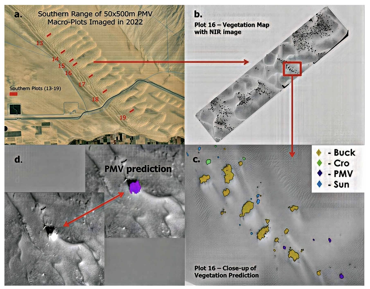
By feeding the precision imagery captured via UgCS into a Random Forest classification model, the researchers achieved a 93.25% average accuracy in identifying individual PMV plants. This level of precision allows state and federal agencies to transition from rough "estimates" to reliable, data-driven conservation monitoring.
"Your software was invaluable for our ultimate success... I want to thank your company and staff for their exceptional support." -Dr. Jeffery R. Best, RavenVision LLC
UgCS: The Standard for Complex Environmental and Conservation Research
The success in the Imperial Sand Dunes showcases the increasingly important role drones are starting to play in the field of environmental monitoring. Whether it is tracking forest recovery after a fire, monitoring rock surfaces, landslide subsidence, or identifying endangered flora in the desert, UgCS provides the drone mission planning data consistency and technical precision that professional researchers require.
Original research: https://www.int-res.com/abstracts/esr/v59/esr01467