
.webp)
Your Drone is Replaceable. Your Workflow Isn't.
Let's be blunt. The entire conversation around potential hardware bans in the U.S. is focused on the wrong problem. We're all asking, "What drone do I buy next?" when the real question - the one that will determine who is still in business in five years, is, "How do I build a drone program that can survive any hardware change?"
The answer isn't in a new airframe. It's in your drone software.
For too long, professional operators have allowed their entire operational workflow to be held hostage by a single hardware manufacturer. Your training, your safety procedures, and your mission data are all tied to an ecosystem you don't control. This is a strategic error, and in today's climate, it's a business-ending mistake. It’s time to de-couple your workflow from your hardware.
The Hardware Trap: Why Closed Ecosystems are a House of Cards
When your flight planning, fleet management, and data logging all run through a single brand's proprietary app, you haven't built a business process. You've simply learned to use one company's product. Your Standard Operating Procedures (SOPs), the very DNA of your professional service, become fragile because they are defined by the limitations and features of that one app.
Consider a survey company whose pilots are trained exclusively on a closed system. Their expertise is not in drone mapping in general; it’s in using one specific tool. What happens if that tool is no longer an option? The entire operational knowledge base collapses. Pilots need to be retrained on a new interface. Safety manuals, written around the old system's warnings and features, must be rewritten. Access to years of flight logs for compliance could be compromised.
You're not just replacing a drone; you're rebuilding your entire operational foundation from scratch, while your competitors keep flying.
The Universal Translator: How Platform-Agnostic Software Creates Resilience
The only way to build a truly resilient, future-proof drone program is to make the mission planner the unshakable foundation of your operation. A professional, hardware-agnostic platform like UgCS acts as a universal translator, allowing you to treat drones as interchangeable tools while your core workflow remains constant, secure, and continuously improving.
A Single Pane of Glass for a Mixed Fleet
Professionals use the right tool for the job. You wouldn't use a screwdriver to hammer a nail. So why would your software force you into a one-size-fits-all approach? A platform-agnostic planner allows you to run a mixed fleet from a single, unified interface.
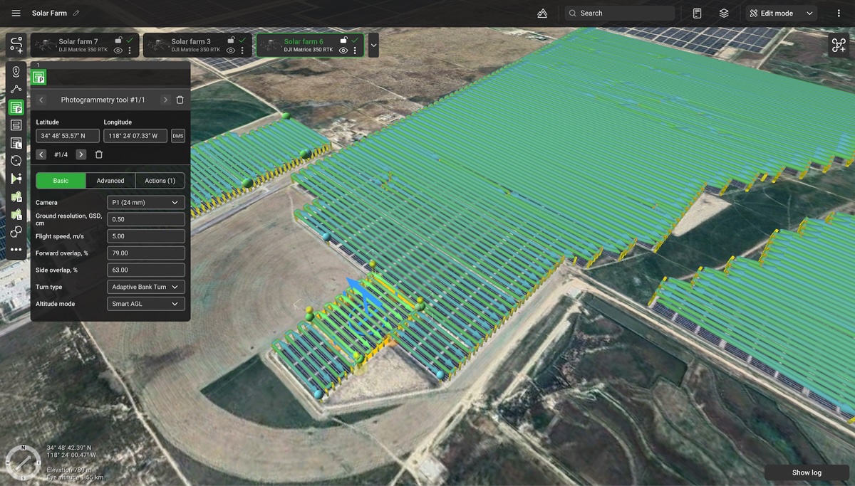
Imagine planning three missions in one afternoon from one desktop. The first is a standard drone photogrammetry survey with a DJI Matrice 350. The second is a corridor inspection using an NDAA-compliant Inspired Flight IF1200A. The third is a BVLOS test flight with a custom ArduPilot build. With UgCS, your pilot uses the exact same software, interface, and safety checks for all three. The muscle memory, the safety checks, and the entire planning process remain identical. This is the definition of operational efficiency.
Specialized Toolsets for Every Professional Payload
A professional workflow is defined by its ability to handle specialized, high-value sensors. This is where the difference between a basic app, true photogrammetry software, and sensor planner becomes obvious. It's not just about flying waypoints; it's about optimizing the flight path to the sensor's unique needs.
For a drone with lidar camera, a dedicated toolset (UgCS is the only on the market, by the way) is essential. Simply flying a grid is an amateur move. A professional lidar drone mission requires planning calibration patterns, ensuring precise line spacing for data integrity, and using high-resolution terrain models for true AGL altitude control. This is the only way to guarantee a consistent point density and flight safety across the entire survey area. UgCS is the only planner with a complete drone lidar toolset designed for these exacting requirements.
.jpg)
For drones with thermal cameras, capturing clean thermal images depends on maintaining optimal sensor angles to avoid sun glare and ensuring consistent speed for accurate temperature readings. UgCS allows you to pre-plan every variable, including gimbal pitch and flight speed at each waypoint, to guarantee usable data. This level of control is simply not available in most single-brand apps.
True 3D Planning for a 3D World
Serious drone mapping cannot be planned effectively on a 2D phone screen in the field. Professional missions are planned on a desktop, where you have the screen real estate and processing power to analyze all available data. UgCS allows you to import high-resolution Digital Elevation Models (DEMs), client-provided KMLs showing obstacles, and custom map overlays. You can see your mission in a true 3D environment, identify potential conflicts, and simulate the entire flight before you ever leave the office.
Furthermore, this entire process works completely offline. For professionals working in remote mining, energy, or environmental sectors, this isn't a luxury; it's a requirement. You can plan in the office, and execute in the field with zero reliance on a cellular connection.
And it’s not only that. With UgCS you own the flight plans of all of the projects you make. Forever. Any flight plan or project can be exported from UgCS to any other software.
The Bottom Line: Your Workflow is Your Most Valuable Asset
Stop asking which drone to buy next. Start building an operational workflow that makes that question irrelevant.
A professional photography studio doesn't define itself by owning only Canon cameras; it defines itself by its consistent process of lighting, composition, and post-production that can be applied to any camera system. A professional drone business must adopt the same mindset.
Investing tens of thousands of dollars in a new lidar drone or thermal sensor is a strategic failure if your planning software can't adapt to the next compliant airframe. The most valuable asset in your drone program isn't the hardware you own today; it's the standardized, repeatable, and hardware-independent workflow that will keep you flying and profitable tomorrow. That is the only real security.